Tauche elevation
Tauche (Brandenburg), Germany elevation is 56 meters and Tauche elevation in feet is 184 ft above sea level [src 1]. Tauche is a seat of a fourth-order administrative division (feature code) with elevation that is 202 meters (663 ft) smaller than average city elevation in Germany.
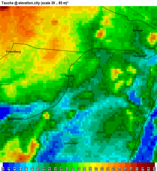
Below is the Elevation map of Tauche, which displays elevation range with different colors. Scale of the first map is from 39 to 85 m (128 to 279 ft) with average elevation of 57.2 meters (=188 ft) [note 1]
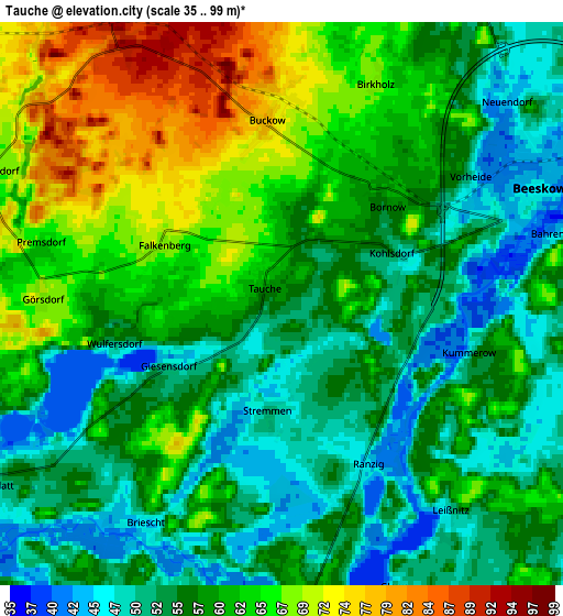
These maps also provides idea of topography and contour of this city, they are displayed at different zoom levels. More info about maps, scale and edge coordinates you can find below images.
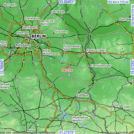
| \ | Map #1 | Map #2 | Topo.Map |
| Scale [m] | 39..85 m | 35..99 m | × |
| Scale [ft] | 128..279 ft | 115..325 ft | × |
| Average | 57.2 m = 188 ft | 58.6 m = 192 ft | × |
| Width | 6 km = 3.7 mi | 11.99 km = 7.5 mi | 191.9 km = 119.2 mi |
| Height | 6 km = 3.7 mi | 11.99 km = 7.5 mi | 191.9 km = 119.2 mi |
| ↑Max Latitude | 52.176957° | 52.203897° | 53.00453° |
| Latitude at center | 52.15° | 52.15° | 52.15° |
| ↓Min Latitude | 52.123027° | 52.096038° | 51.27875° |
| ← Min Longitude | 14.122725° | 14.078779° | 12.76042° |
| Longitude center | 14.16667° | 14.16667° | 14.16667° |
| →Max Longitude | 14.210615° | 14.254561° | 15.57292° |
Nearby cities:
Cities around Tauche sort by population:
• Storkow elevation 39 m
19.8 km,  306°
306°
• Beeskow 46 m
6 km,  64°
64°
• Bad Saarow 52 m
16.3 km,  335°
335°
• Rietz Neuendorf 80 m
8.6 km,  3°
3°
• Müllrose 43 m
20.3 km, 57°
• Friedland 53 m
8.3 km,  127°
127°
• Rauen 70 m
22.4 km, 335°
• Lieberose 52 m
20.5 km,  153°
153°
• Wendisch Rietz 42 m
13.1 km,  304°
304°
• Reichenwalde 67 m
17.2 km,  318°
318°
• Mixdorf 57 m
16.9 km,  70°
70°
• Berkenbrück 41 m
22.3 km,  357°
357°
Multilingual:
 En español:
Tauche elevación 56 m.
 En France:
Tauche élévation 56 m.


Sources and notes:
- [note 1] Map square and city borders are not equal. Map elevation data is calculated only from area inside that square.
- [src 1] Elevation data from geonames database provided with same terms of usage.
- [src 2] The elevation map of Tauche is generated using elevation data from NASA's 3 arcsec (90m) resolution SRTM data.
- [src 3] Base (background) map © OpenStreetMap contributors tiles are generated by Geofabrik and OpenTopoMap.
Copyright & License:
This Tauche Elevation Map is licensed under CC BY-SA. You may reuse any part from this page, if you give a proper credit by linking to this URL:
 More info on terms of use page.