Müllrose elevation
Müllrose (Brandenburg), Germany elevation is 43 meters and Müllrose elevation in feet is 141 ft above sea level [src 1]. Müllrose is a populated place (feature code) with elevation that is 215 meters (705 ft) smaller than average city elevation in Germany.
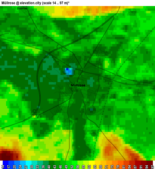
Below is the Elevation map of Müllrose, which displays elevation range with different colors. Scale of the first map is from 14 to 97 m (46 to 318 ft) with average elevation of 49.5 meters (=162 ft) [note 1]
These maps also provides idea of topography and contour of this city, they are displayed at different zoom levels. More info about maps, scale and edge coordinates you can find below images.
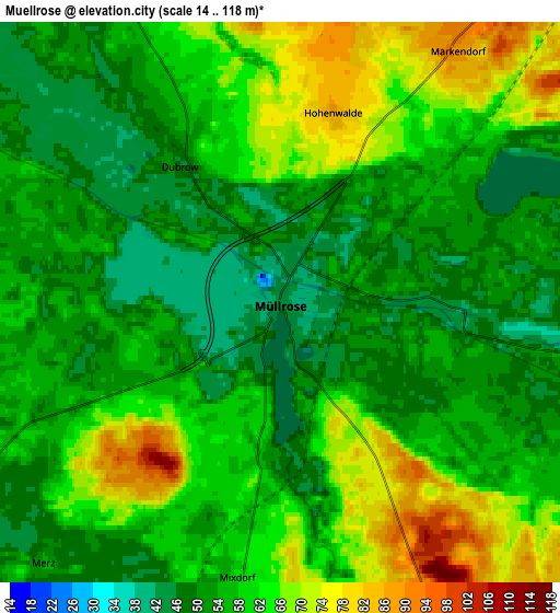
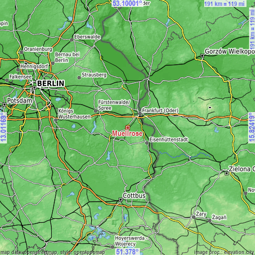
| \ | Map #1 | Map #2 | Topo.Map |
| Scale [m] | 14..97 m | 14..118 m | × |
| Scale [ft] | 46..318 ft | 46..387 ft | × |
| Average | 49.5 m = 162 ft | 57.8 m = 190 ft | × |
| Width | 5.98 km = 3.7 mi | 11.97 km = 7.4 mi | 191.5 km = 119 mi |
| Height | 5.98 km = 3.7 mi | 11.97 km = 7.4 mi | 191.5 km = 119 mi |
| ↑Max Latitude | 52.274258° | 52.301139° | 53.10001° |
| Latitude at center | 52.24736° | 52.24736° | 52.24736° |
| ↓Min Latitude | 52.220446° | 52.193516° | 51.378° |
| ← Min Longitude | 14.373995° | 14.330049° | 13.01169° |
| Longitude center | 14.41794° | 14.41794° | 14.41794° |
| →Max Longitude | 14.461885° | 14.505831° | 15.82419° |
Nearby cities:
Cities around Müllrose sort by population:
• Frankfurt (Oder) elevation 28 m
14.3 km,  39°
39°
• Eisenhüttenstadt 41 m
19.2 km,  124°
124°
• Beeskow 46 m
14.3 km,  234°
234°
• Rietz Neuendorf 80 m
16.7 km,  262°
262°
• Friedland 53 m
19 km,  213°
213°
• Brieskow-Finkenheerd 37 m
10.6 km,  86°
86°
• Briesen 42 m
14.3 km,  318°
318°
• Jacobsdorf 60 m
10.6 km,  334°
334°
• Groß Lindow 42 m
8 km,  101°
101°
• Ziltendorf 30 m
14.8 km,  108°
108°
• Wiesenau 31 m
11.9 km, 98°
• Mixdorf 57 m
5.4 km,  193°
193°
Multilingual:
 En español:
Müllrose elevación 43 m.
 En France:
Müllrose élévation 43 m.


Sources and notes:
- [note 1] Map square and city borders are not equal. Map elevation data is calculated only from area inside that square.
- [src 1] Elevation data from geonames database provided with same terms of usage.
- [src 2] The elevation map of Müllrose is generated using elevation data from NASA's 3 arcsec (90m) resolution SRTM data.
- [src 3] Base (background) map © OpenStreetMap contributors tiles are generated by Geofabrik and OpenTopoMap.
Copyright & License:
This Müllrose Elevation Map is licensed under CC BY-SA. You may reuse any part from this page, if you give a proper credit by linking to this URL:
 More info on terms of use page.