Beetzendorf elevation
Beetzendorf (Saxony-Anhalt), Germany elevation is 37 meters and Beetzendorf elevation in feet is 121 ft above sea level [src 1]. Beetzendorf is a seat of a fourth-order administrative division (feature code) with elevation that is 221 meters (725 ft) smaller than average city elevation in Germany.
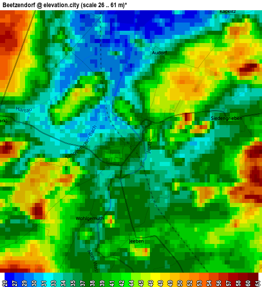
Below is the Elevation map of Beetzendorf, which displays elevation range with different colors. Scale of the first map is from 26 to 61 m (85 to 200 ft) with average elevation of 39.6 meters (=130 ft) [note 1]
These maps also provides idea of topography and contour of this city, they are displayed at different zoom levels. More info about maps, scale and edge coordinates you can find below images.
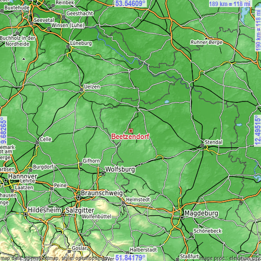
| \ | Map #1 | Topo.Map |
| Scale [m] | 26..61 m | × |
| Scale [ft] | 85..200 ft | × |
| Average | 39.6 m = 130 ft | × |
| Width | 5.92 km = 3.7 mi | 189.5 km = 117.7 mi |
| Height | 5.92 km = 3.7 mi | 189.5 km = 117.7 mi |
| ↑Max Latitude | 52.728881° | 53.54609° |
| Latitude at center | 52.70226° | 52.70226° |
| ↓Min Latitude | 52.675623° | 51.84179° |
| ← Min Longitude | 11.044955° | 9.68265° |
| Longitude center | 11.0889° | 11.0889° |
| →Max Longitude | 11.132845° | 12.49515° |
Nearby cities:
Cities around Beetzendorf sort by population:
• Salzwedel elevation 24 m
17.4 km,  14°
14°
• Wittingen 84 m
23.9 km,  276°
276°
• Klötze 57 m
9.8 km,  148°
148°
• Brome 72 m
15.3 km,  221°
221°
• Wustrow 19 m
24.8 km, 6°
• Kalbe 36 m
20.6 km,  104°
104°
• Parsau 62 m
23 km, 215°
• Bergen an der Dumme 33 m
22.8 km,  336°
336°
• Tülau 75 m
20 km,  225°
225°
• Schnega 40 m
24.8 km,  327°
327°
• Pretzier 39 m
18.5 km,  38°
38°
• Kusey 65 m
13.6 km,  179°
179°
Multilingual:
 En español:
Beetzendorf elevación 37 m.
 En France:
Beetzendorf élévation 37 m.
 Auf Deutsch:
Beetzendorf höhe über dem Meeresspiegel ist 37 m.

Sources and notes:
- [note 1] Map square and city borders are not equal. Map elevation data is calculated only from area inside that square.
- [src 1] Elevation data from geonames database provided with same terms of usage.
- [src 2] The elevation map of Beetzendorf is generated using elevation data from NASA's 3 arcsec (90m) resolution SRTM data.
- [src 3] Base (background) map © OpenStreetMap contributors tiles are generated by Geofabrik and OpenTopoMap.
Copyright & License:
This Beetzendorf Elevation Map is licensed under CC BY-SA. You may reuse any part from this page, if you give a proper credit by linking to this URL:
 More info on terms of use page.