Klötze elevation
Klötze (Saxony-Anhalt), Germany elevation is 57 meters and Klötze elevation in feet is 187 ft above sea level [src 1]. Klötze is a populated place (feature code) with elevation that is 201 meters (659 ft) smaller than average city elevation in Germany.
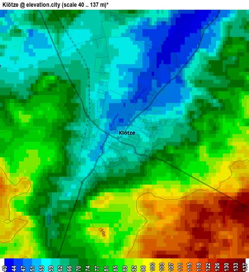
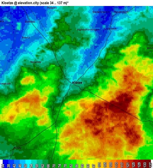
Below is the Elevation map of Klötze, which displays elevation range with different colors. Scale of the first map is from 40 to 137 m (131 to 449 ft) with average elevation of 75.7 meters (=248 ft) [note 1]
These maps also provides idea of topography and contour of this city, they are displayed at different zoom levels. More info about maps, scale and edge coordinates you can find below images.
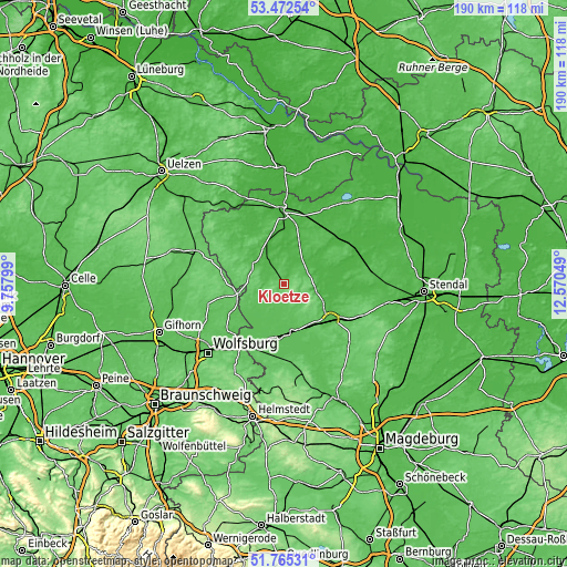
| \ | Map #1 | Map #2 | Topo.Map |
| Scale [m] | 40..137 m | 34..137 m | × |
| Scale [ft] | 131..449 ft | 112..449 ft | × |
| Average | 75.7 m = 248 ft | 76.2 m = 250 ft | × |
| Width | 5.93 km = 3.7 mi | 11.86 km = 7.4 mi | 189.8 km = 117.9 mi |
| Height | 5.93 km = 3.7 mi | 11.86 km = 7.4 mi | 189.8 km = 117.9 mi |
| ↑Max Latitude | 52.653917° | 52.680567° | 53.47254° |
| Latitude at center | 52.62725° | 52.62725° | 52.62725° |
| ↓Min Latitude | 52.600567° | 52.573868° | 51.76531° |
| ← Min Longitude | 11.120295° | 11.076349° | 9.75799° |
| Longitude center | 11.16424° | 11.16424° | 11.16424° |
| →Max Longitude | 11.208185° | 11.252131° | 12.57049° |
Nearby cities:
Cities around Klötze sort by population:
• Gardelegen elevation 49 m
19.3 km,  126°
126°
• Oebisfelde 63 m
24.6 km,  209°
209°
• Rühen 68 m
24.5 km,  230°
230°
• Brome 72 m
15.6 km,  258°
258°
• Kalbe 36 m
15.2 km,  77°
77°
• Mieste 60 m
16.4 km,  169°
169°
• Parsau 62 m
21.2 km,  240°
240°
• Beetzendorf 37 m
9.8 km,  328°
328°
• Tülau 75 m
20.1 km,  253°
253°
• Pretzier 39 m
23.7 km,  15°
15°
• Kusey 65 m
7.2 km,  223°
223°
• Grafhorst 61 m
25.1 km, 216°
Multilingual:
 En español:
Klötze elevación 57 m.
 En France:
Klötze élévation 57 m.


Sources and notes:
- [note 1] Map square and city borders are not equal. Map elevation data is calculated only from area inside that square.
- [src 1] Elevation data from geonames database provided with same terms of usage.
- [src 2] The elevation map of Klötze is generated using elevation data from NASA's 3 arcsec (90m) resolution SRTM data.
- [src 3] Base (background) map © OpenStreetMap contributors tiles are generated by Geofabrik and OpenTopoMap.
Copyright & License:
This Klötze Elevation Map is licensed under CC BY-SA. You may reuse any part from this page, if you give a proper credit by linking to this URL:
 More info on terms of use page.