Berga elevation
Berga (Thuringia), Germany elevation is 240 meters and Berga elevation in feet is 787 ft above sea level [src 1]. Berga is a populated place (feature code) with elevation that is 18 meters (59 ft) smaller than average city elevation in Germany.
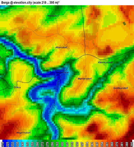
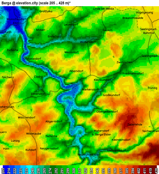
Below is the Elevation map of Berga, which displays elevation range with different colors. Scale of the first map is from 218 to 395 m (715 to 1296 ft) with average elevation of 314.6 meters (=1032 ft) [note 1]
These maps also provides idea of topography and contour of this city, they are displayed at different zoom levels. More info about maps, scale and edge coordinates you can find below images.
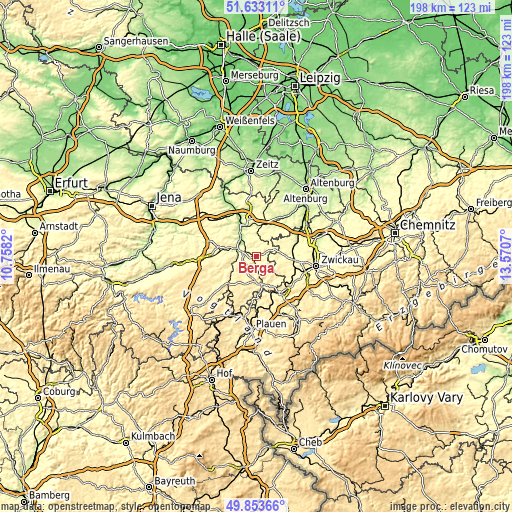
| \ | Map #1 | Map #2 | Topo.Map |
| Scale [m] | 218..395 m | 205..428 m | × |
| Scale [ft] | 715..1296 ft | 673..1404 ft | × |
| Average | 314.6 m = 1032 ft | 320.2 m = 1051 ft | × |
| Width | 6.18 km = 3.8 mi | 12.37 km = 7.7 mi | 197.9 km = 123 mi |
| Height | 6.18 km = 3.8 mi | 12.37 km = 7.7 mi | 197.8 km = 122.9 mi |
| ↑Max Latitude | 50.779635° | 50.807414° | 51.63311° |
| Latitude at center | 50.75184° | 50.75184° | 50.75184° |
| ↓Min Latitude | 50.724028° | 50.6962° | 49.85366° |
| ← Min Longitude | 12.120505° | 12.076559° | 10.7582° |
| Longitude center | 12.16445° | 12.16445° | 12.16445° |
| →Max Longitude | 12.208395° | 12.252341° | 13.5707° |
Nearby cities:
Cities around Berga sort by population:
• Greiz elevation 269 m
10.7 km,  166°
166°
• Weida 239 m
7.7 km,  288°
288°
• Ronneburg 284 m
12.5 km,  7°
7°
• Triebes 354 m
12.6 km,  233°
233°
• Langenbernsdorf 279 m
11.4 km,  87°
87°
• Langenwetzendorf 341 m
9.5 km,  211°
211°
• Wünschendorf 214 m
6.8 km,  316°
316°
• Mohlsdorf 313 m
11.6 km,  142°
142°
• Teichwolframsdorf 314 m
6.7 km,  120°
120°
• Hohenleuben 393 m
9 km,  239°
239°
• Seelingstädt 303 m
6 km,  67°
67°
• Leubnitz 291 m
13.9 km,  103°
103°
Multilingual:
 En español:
Berga elevación 240 m.
 En France:
Berga élévation 240 m.


Sources and notes:
- [note 1] Map square and city borders are not equal. Map elevation data is calculated only from area inside that square.
- [src 1] Elevation data from geonames database provided with same terms of usage.
- [src 2] The elevation map of Berga is generated using elevation data from NASA's 3 arcsec (90m) resolution SRTM data.
- [src 3] Base (background) map © OpenStreetMap contributors tiles are generated by Geofabrik and OpenTopoMap.
Copyright & License:
This Berga Elevation Map is licensed under CC BY-SA. You may reuse any part from this page, if you give a proper credit by linking to this URL:
 More info on terms of use page.