Biessenhofen elevation
Biessenhofen (Bavaria, Swabia), Germany elevation is 699 meters and Biessenhofen elevation in feet is 2293 ft above sea level [src 1]. Biessenhofen is a seat of a fourth-order administrative division (feature code) with elevation that is 441 meters (1447 ft) bigger than average city elevation in Germany.
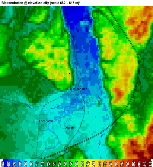
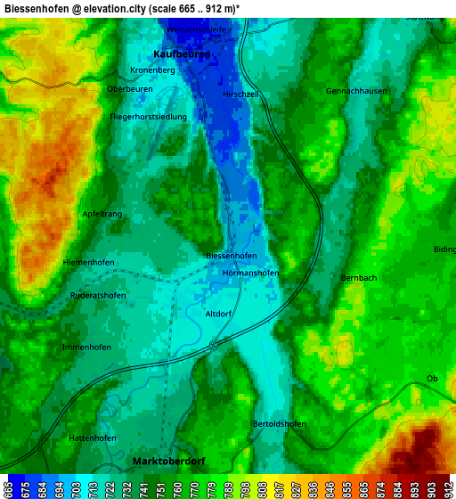
Below is the Elevation map of Biessenhofen, which displays elevation range with different colors. Scale of the first map is from 682 to 818 m (2238 to 2684 ft) with average elevation of 729 meters (=2392 ft) [note 1]
These maps also provides idea of topography and contour of this city, they are displayed at different zoom levels. More info about maps, scale and edge coordinates you can find below images.
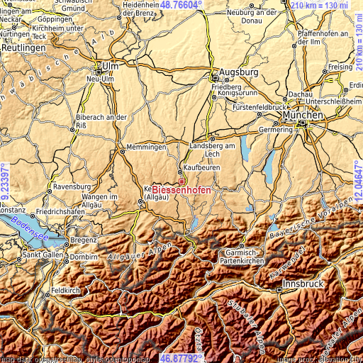
| \ | Map #1 | Map #2 | Topo.Map |
| Scale [m] | 682..818 m | 665..912 m | × |
| Scale [ft] | 2238..2684 ft | 2182..2992 ft | × |
| Average | 729 m = 2392 ft | 753.5 m = 2472 ft | × |
| Width | 6.56 km = 4.1 mi | 13.12 km = 8.2 mi | 209.9 km = 130.4 mi |
| Height | 6.56 km = 4.1 mi | 13.12 km = 8.2 mi | 209.9 km = 130.4 mi |
| ↑Max Latitude | 47.860063° | 47.88954° | 48.76604° |
| Latitude at center | 47.83057° | 47.83057° | 47.83057° |
| ↓Min Latitude | 47.80106° | 47.771533° | 46.87792° |
| ← Min Longitude | 10.596275° | 10.552329° | 9.23397° |
| Longitude center | 10.64022° | 10.64022° | 10.64022° |
| →Max Longitude | 10.684165° | 10.728111° | 12.04647° |
Nearby cities:
Cities around Biessenhofen sort by population:
• Kaufbeuren elevation 672 m
5.9 km,  346°
346°
• Marktoberdorf 728 m
5.9 km,  196°
196°
• Mauerstetten 725 m
7.4 km,  18°
18°
• Unterthingau 773 m
12.1 km,  237°
237°
• Pforzen 656 m
11.2 km, 349°
• Aitrang 745 m
8.1 km,  259°
259°
• Stötten am Auerberg 734 m
10.8 km,  160°
160°
• Stöttwang 740 m
8.2 km,  44°
44°
• Bidingen 764 m
6.4 km,  90°
90°
• Ruderatshofen 742 m
4.5 km,  250°
250°
• Friesenried 740 m
9.3 km,  301°
301°
• Irsee 746 m
10 km,  329°
329°
Multilingual:
 En español:
Biessenhofen elevación 699 m.
 En France:
Biessenhofen élévation 699 m.
 Auf Deutsch:
Biessenhofen höhe über dem Meeresspiegel ist 699 m.

Sources and notes:
- [note 1] Map square and city borders are not equal. Map elevation data is calculated only from area inside that square.
- [src 1] Elevation data from geonames database provided with same terms of usage.
- [src 2] The elevation map of Biessenhofen is generated using elevation data from NASA's 3 arcsec (90m) resolution SRTM data.
- [src 3] Base (background) map © OpenStreetMap contributors tiles are generated by Geofabrik and OpenTopoMap.
Copyright & License:
This Biessenhofen Elevation Map is licensed under CC BY-SA. You may reuse any part from this page, if you give a proper credit by linking to this URL:
 More info on terms of use page.