Aitrang elevation
Aitrang (Bavaria, Swabia), Germany elevation is 745 meters and Aitrang elevation in feet is 2444 ft above sea level [src 1]. Aitrang is a seat of a fourth-order administrative division (feature code) with elevation that is 487 meters (1598 ft) bigger than average city elevation in Germany.
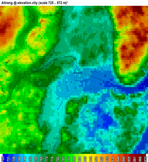
Below is the Elevation map of Aitrang, which displays elevation range with different colors. Scale of the first map is from 725 to 872 m (2379 to 2861 ft) with average elevation of 777.3 meters (=2550 ft) [note 1]
These maps also provides idea of topography and contour of this city, they are displayed at different zoom levels. More info about maps, scale and edge coordinates you can find below images.
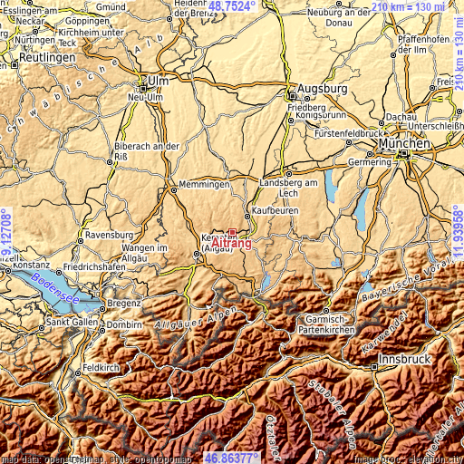
| \ | Map #1 | Topo.Map |
| Scale [m] | 725..872 m | × |
| Scale [ft] | 2379..2861 ft | × |
| Average | 777.3 m = 2550 ft | × |
| Width | 6.56 km = 4.1 mi | 210 km = 130.5 mi |
| Height | 6.56 km = 4.1 mi | 210 km = 130.5 mi |
| ↑Max Latitude | 47.846171° | 48.7524° |
| Latitude at center | 47.81667° | 47.81667° |
| ↓Min Latitude | 47.787152° | 46.86377° |
| ← Min Longitude | 10.489385° | 9.12708° |
| Longitude center | 10.53333° | 10.53333° |
| →Max Longitude | 10.577275° | 11.93958° |
Nearby cities:
Cities around Aitrang sort by population:
• Kaufbeuren elevation 672 m
9.9 km,  42°
42°
• Marktoberdorf 728 m
7.5 km,  123°
123°
• Obergünzburg 737 m
9.2 km,  290°
290°
• Biessenhofen 699 m
8.1 km,  79°
79°
• Unterthingau 773 m
5.5 km,  203°
203°
• Wildpoldsried 723 m
11.4 km,  240°
240°
• Ruderatshofen 742 m
3.7 km,  90°
90°
• Friesenried 740 m
6.5 km,  0°
0°
• Günzach 774 m
7.4 km,  277°
277°
• Untrasried 855 m
11.4 km, 279°
• Irsee 746 m
10.6 km,  15°
15°
• Eggenthal 703 m
11.2 km,  353°
353°
Multilingual:
 En español:
Aitrang elevación 745 m.
 En France:
Aitrang élévation 745 m.


Sources and notes:
- [note 1] Map square and city borders are not equal. Map elevation data is calculated only from area inside that square.
- [src 1] Elevation data from geonames database provided with same terms of usage.
- [src 2] The elevation map of Aitrang is generated using elevation data from NASA's 3 arcsec (90m) resolution SRTM data.
- [src 3] Base (background) map © OpenStreetMap contributors tiles are generated by Geofabrik and OpenTopoMap.
Copyright & License:
This Aitrang Elevation Map is licensed under CC BY-SA. You may reuse any part from this page, if you give a proper credit by linking to this URL:
 More info on terms of use page.