Stöttwang elevation
Stöttwang (Bavaria, Swabia), Germany elevation is 740 meters and Stöttwang elevation in feet is 2428 ft above sea level [src 1]. Stöttwang is a seat of a fourth-order administrative division (feature code) with elevation that is 482 meters (1581 ft) bigger than average city elevation in Germany.
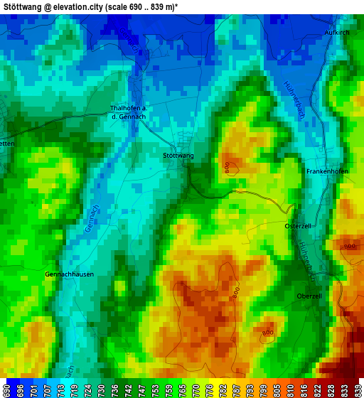
Below is the Elevation map of Stöttwang, which displays elevation range with different colors. Scale of the first map is from 690 to 839 m (2264 to 2753 ft) with average elevation of 744.5 meters (=2443 ft) [note 1]
These maps also provides idea of topography and contour of this city, they are displayed at different zoom levels. More info about maps, scale and edge coordinates you can find below images.
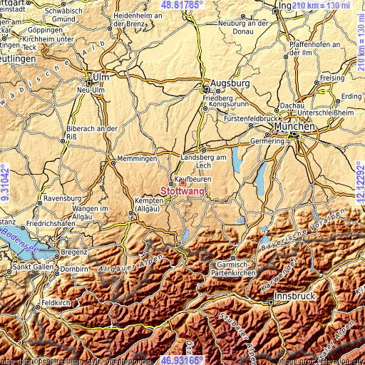
| \ | Map #1 | Topo.Map |
| Scale [m] | 690..839 m | × |
| Scale [ft] | 2264..2753 ft | × |
| Average | 744.5 m = 2443 ft | × |
| Width | 6.55 km = 4.1 mi | 209.7 km = 130.3 mi |
| Height | 6.55 km = 4.1 mi | 209.7 km = 130.3 mi |
| ↑Max Latitude | 47.912793° | 48.81785° |
| Latitude at center | 47.88333° | 47.88333° |
| ↓Min Latitude | 47.85385° | 46.93165° |
| ← Min Longitude | 10.672725° | 9.31042° |
| Longitude center | 10.71667° | 10.71667° |
| →Max Longitude | 10.760615° | 12.12292° |
Nearby cities:
Cities around Stöttwang sort by population:
• Kaufbeuren elevation 672 m
7.1 km,  269°
269°
• Biessenhofen 699 m
8.2 km,  224°
224°
• Mauerstetten 725 m
3.6 km,  288°
288°
• Denklingen 684 m
10.6 km,  69°
69°
• Pforzen 656 m
9.3 km,  304°
304°
• Westendorf 679 m
5.6 km,  0°
0°
• Bidingen 764 m
6 km,  173°
173°
• Ruderatshofen 742 m
12.4 km,  233°
233°
• Irsee 746 m
11.1 km,  284°
284°
• Schwabsoien 735 m
10.3 km,  122°
122°
• Oberostendorf 677 m
7 km,  16°
16°
• Rieden 659 m
8.9 km,  326°
326°
Multilingual:
 En español:
Stöttwang elevación 740 m.
 En France:
Stöttwang élévation 740 m.
 Auf Deutsch:
Stöttwang höhe über dem Meeresspiegel ist 740 m.

Sources and notes:
- [note 1] Map square and city borders are not equal. Map elevation data is calculated only from area inside that square.
- [src 1] Elevation data from geonames database provided with same terms of usage.
- [src 2] The elevation map of Stöttwang is generated using elevation data from NASA's 3 arcsec (90m) resolution SRTM data.
- [src 3] Base (background) map © OpenStreetMap contributors tiles are generated by Geofabrik and OpenTopoMap.
Copyright & License:
This Stöttwang Elevation Map is licensed under CC BY-SA. You may reuse any part from this page, if you give a proper credit by linking to this URL:
 More info on terms of use page.