Binau elevation
Binau (Baden-Württemberg, Karlsruhe Region), Germany elevation is 169 meters and Binau elevation in feet is 554 ft above sea level [src 1]. Binau is a seat of a fourth-order administrative division (feature code) with elevation that is 89 meters (292 ft) smaller than average city elevation in Germany.
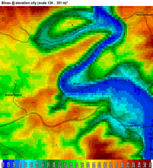
Below is the Elevation map of Binau, which displays elevation range with different colors. Scale of the first map is from 126 to 351 m (413 to 1152 ft) with average elevation of 231.9 meters (=761 ft) [note 1]
These maps also provides idea of topography and contour of this city, they are displayed at different zoom levels. More info about maps, scale and edge coordinates you can find below images.
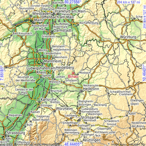
| \ | Map #1 | Topo.Map |
| Scale [m] | 126..351 m | × |
| Scale [ft] | 413..1152 ft | × |
| Average | 231.9 m = 761 ft | × |
| Width | 6.36 km = 4 mi | 203.6 km = 126.5 mi |
| Height | 6.36 km = 4 mi | 203.6 km = 126.5 mi |
| ↑Max Latitude | 49.396939° | 50.27556° |
| Latitude at center | 49.36833° | 49.36833° |
| ↓Min Latitude | 49.339705° | 48.44405° |
| ← Min Longitude | 9.014115° | 7.65181° |
| Longitude center | 9.05806° | 9.05806° |
| →Max Longitude | 9.102005° | 10.46431° |
Nearby cities:
Cities around Binau sort by population:
• Mosbach elevation 186 m
6.9 km,  103°
103°
• Obrigheim 150 m
3 km,  127°
127°
• Aglasterhausen 205 m
5.3 km,  256°
256°
• Haßmersheim 151 m
10.1 km,  138°
138°
• Neckarbischofsheim 187 m
10.5 km,  220°
220°
• Helmstadt-Bargen 193 m
7.5 km, 216°
• Fahrenbach 367 m
9.7 km,  43°
43°
• Neckargerach 133 m
3.6 km,  10°
10°
• Hüffenhardt 303 m
8.7 km,  168°
168°
• Reichartshausen 224 m
8.3 km, 259°
• Neunkirchen 294 m
4 km,  301°
301°
• Neckarzimmern 153 m
7.7 km, 135°
Multilingual:
 En español:
Binau elevación 169 m.
 En France:
Binau élévation 169 m.


Sources and notes:
- [note 1] Map square and city borders are not equal. Map elevation data is calculated only from area inside that square.
- [src 1] Elevation data from geonames database provided with same terms of usage.
- [src 2] The elevation map of Binau is generated using elevation data from NASA's 3 arcsec (90m) resolution SRTM data.
- [src 3] Base (background) map © OpenStreetMap contributors tiles are generated by Geofabrik and OpenTopoMap.
Copyright & License:
This Binau Elevation Map is licensed under CC BY-SA. You may reuse any part from this page, if you give a proper credit by linking to this URL:
 More info on terms of use page.