Bischoffen elevation
Bischoffen (Hesse, Regierungsbezirk Gießen), Germany elevation is 282 meters and Bischoffen elevation in feet is 925 ft above sea level [src 1]. Bischoffen is a seat of a fourth-order administrative division (feature code) with elevation that is 24 meters (79 ft) bigger than average city elevation in Germany.
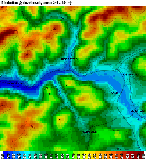
Below is the Elevation map of Bischoffen, which displays elevation range with different colors. Scale of the first map is from 241 to 451 m (791 to 1480 ft) with average elevation of 329.4 meters (=1081 ft) [note 1]
These maps also provides idea of topography and contour of this city, they are displayed at different zoom levels. More info about maps, scale and edge coordinates you can find below images.
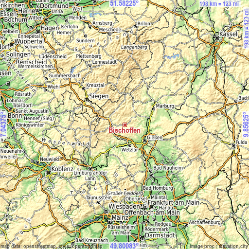
| \ | Map #1 | Topo.Map |
| Scale [m] | 241..451 m | × |
| Scale [ft] | 791..1480 ft | × |
| Average | 329.4 m = 1081 ft | × |
| Width | 6.19 km = 3.8 mi | 198.1 km = 123.1 mi |
| Height | 6.19 km = 3.8 mi | 198.1 km = 123.1 mi |
| ↑Max Latitude | 50.727826° | 51.58225° |
| Latitude at center | 50.7° | 50.7° |
| ↓Min Latitude | 50.672158° | 49.80083° |
| ← Min Longitude | 8.406055° | 7.04375° |
| Longitude center | 8.45° | 8.45° |
| →Max Longitude | 8.493945° | 9.85625° |
Nearby cities:
Cities around Bischoffen sort by population:
• Wetzlar elevation 169 m
15.9 km,  165°
165°
• Dillenburg 232 m
12.4 km,  291°
291°
• Herborn 205 m
10.5 km,  258°
258°
• Aßlar 166 m
12.1 km,  175°
175°
• Gladenbach 267 m
11.9 km,  50°
50°
• Ehringshausen 175 m
12.1 km,  202°
202°
• Bad Endbach 359 m
6.6 km,  32°
32°
• Greifenstein 351 m
14.1 km,  228°
228°
• Sinn 213 m
9.9 km,  235°
235°
• Lohra 206 m
13.4 km,  73°
73°
• Mittenaar 324 m
4.7 km,  270°
270°
• Merkenbach 252 m
11.9 km,  245°
245°
Multilingual:
 En español:
Bischoffen elevación 282 m.
 En France:
Bischoffen élévation 282 m.
 Auf Deutsch:
Bischoffen höhe über dem Meeresspiegel ist 282 m.

Sources and notes:
- [note 1] Map square and city borders are not equal. Map elevation data is calculated only from area inside that square.
- [src 1] Elevation data from geonames database provided with same terms of usage.
- [src 2] The elevation map of Bischoffen is generated using elevation data from NASA's 3 arcsec (90m) resolution SRTM data.
- [src 3] Base (background) map © OpenStreetMap contributors tiles are generated by Geofabrik and OpenTopoMap.
Copyright & License:
This Bischoffen Elevation Map is licensed under CC BY-SA. You may reuse any part from this page, if you give a proper credit by linking to this URL:
 More info on terms of use page.