Lohra elevation
Lohra (Hesse, Regierungsbezirk Gießen), Germany elevation is 206 meters and Lohra elevation in feet is 676 ft above sea level [src 1]. Lohra is a seat of a fourth-order administrative division (feature code) with elevation that is 52 meters (171 ft) smaller than average city elevation in Germany.
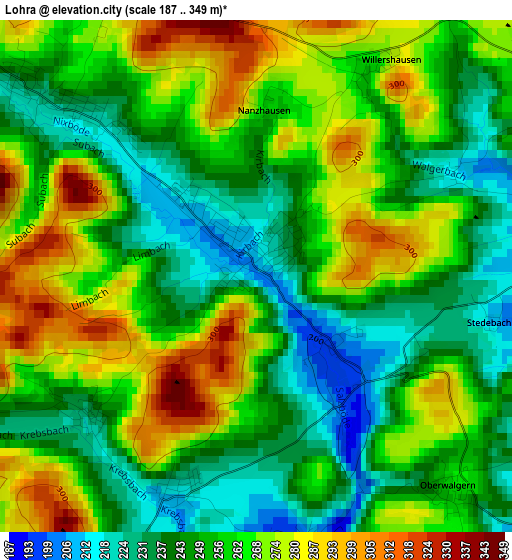
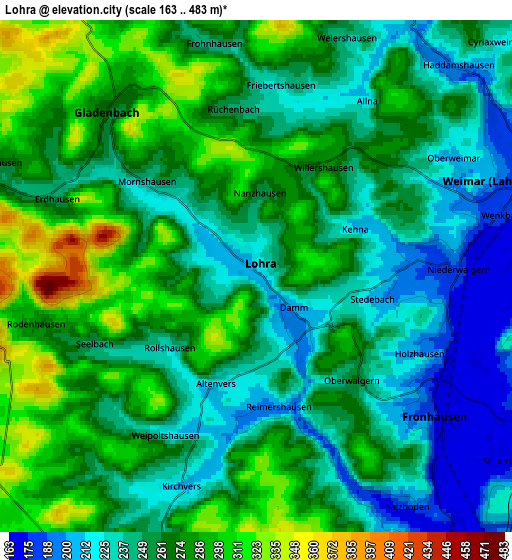
Below is the Elevation map of Lohra, which displays elevation range with different colors. Scale of the first map is from 187 to 349 m (614 to 1145 ft) with average elevation of 256.7 meters (=842 ft) [note 1]
These maps also provides idea of topography and contour of this city, they are displayed at different zoom levels. More info about maps, scale and edge coordinates you can find below images.
| \ | Map #1 | Map #2 | Topo.Map |
| Scale [m] | 187..349 m | 163..483 m | × |
| Scale [ft] | 614..1145 ft | 535..1585 ft | × |
| Average | 256.7 m = 842 ft | 259.9 m = 853 ft | × |
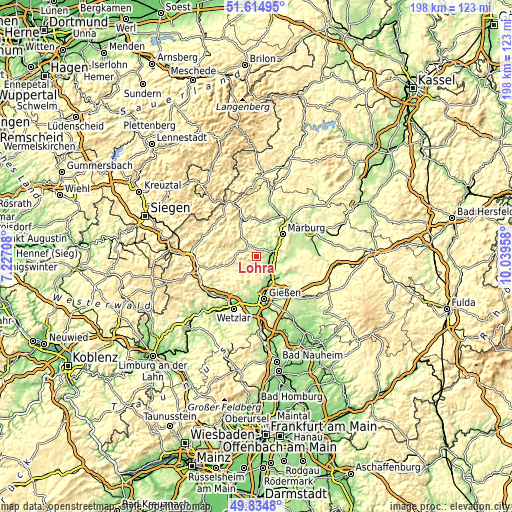
| Width | 6.19 km = 3.8 mi | 12.37 km = 7.7 mi | 197.9 km = 123 mi |
| Height | 6.19 km = 3.8 mi | 12.37 km = 7.7 mi | 197.9 km = 123 mi |
| ↑Max Latitude | 50.761136° | 50.788926° | 51.61495° |
| Latitude at center | 50.73333° | 50.73333° | 50.73333° |
| ↓Min Latitude | 50.705507° | 50.677668° | 49.8348° |
| ← Min Longitude | 8.589385° | 8.545439° | 7.22708° |
| Longitude center | 8.63333° | 8.63333° | 8.63333° |
| →Max Longitude | 8.677275° | 8.721221° | 10.03958° |
Nearby cities:
Cities around Lohra sort by population:
• Marburg an der Lahn elevation 220 m
12.8 km,  48°
48°
• Gießen 162 m
16.5 km,  169°
169°
• Gladenbach 267 m
5.4 km,  316°
316°
• Lollar 166 m
10.9 km,  152°
152°
• Bad Endbach 359 m
9.6 km,  281°
281°
• Staufenberg 209 m
10.5 km,  138°
138°
• Heuchelheim 161 m
16.7 km,  180°
180°
• Cölbe 213 m
16.7 km,  38°
38°
• Rabenau 236 m
17.4 km,  110°
110°
• Fronhausen 167 m
6 km,  128°
128°
• Alten Buseck 229 m
15 km, 145°
• Bischoffen 282 m
13.4 km,  253°
253°
Multilingual:
 En español:
Lohra elevación 206 m.
 En France:
Lohra élévation 206 m.


Sources and notes:
- [note 1] Map square and city borders are not equal. Map elevation data is calculated only from area inside that square.
- [src 1] Elevation data from geonames database provided with same terms of usage.
- [src 2] The elevation map of Lohra is generated using elevation data from NASA's 3 arcsec (90m) resolution SRTM data.
- [src 3] Base (background) map © OpenStreetMap contributors tiles are generated by Geofabrik and OpenTopoMap.
Copyright & License:
This Lohra Elevation Map is licensed under CC BY-SA. You may reuse any part from this page, if you give a proper credit by linking to this URL:
 More info on terms of use page.