Cölbe elevation
Cölbe (Hesse, Regierungsbezirk Gießen), Germany elevation is 213 meters and Cölbe elevation in feet is 699 ft above sea level [src 1]. Cölbe is a seat of a fourth-order administrative division (feature code) with elevation that is 45 meters (148 ft) smaller than average city elevation in Germany.
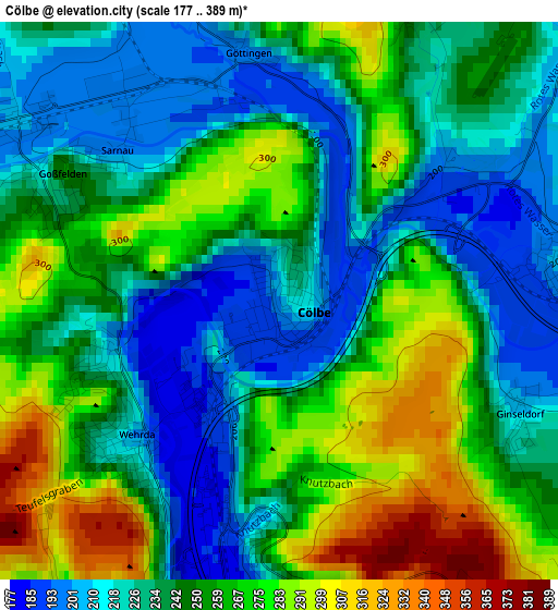
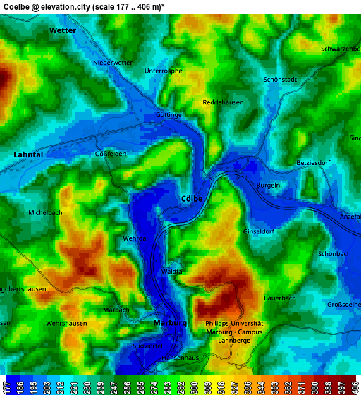
Below is the Elevation map of Cölbe, which displays elevation range with different colors. Scale of the first map is from 177 to 389 m (581 to 1276 ft) with average elevation of 246.9 meters (=810 ft) [note 1]
These maps also provides idea of topography and contour of this city, they are displayed at different zoom levels. More info about maps, scale and edge coordinates you can find below images.
| \ | Map #1 | Map #2 | Topo.Map |
| Scale [m] | 177..389 m | 177..406 m | × |
| Scale [ft] | 581..1276 ft | 581..1332 ft | × |
| Average | 246.9 m = 810 ft | 254.1 m = 834 ft | × |
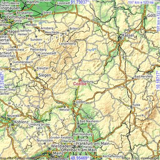
| Width | 6.17 km = 3.8 mi | 12.34 km = 7.7 mi | 197.4 km = 122.7 mi |
| Height | 6.17 km = 3.8 mi | 12.34 km = 7.7 mi | 197.4 km = 122.7 mi |
| ↑Max Latitude | 50.878716° | 50.906436° | 51.73037° |
| Latitude at center | 50.85098° | 50.85098° | 50.85098° |
| ↓Min Latitude | 50.823227° | 50.795458° | 49.95469° |
| ← Min Longitude | 8.736975° | 8.693029° | 7.37467° |
| Longitude center | 8.78092° | 8.78092° | 8.78092° |
| →Max Longitude | 8.824865° | 8.868811° | 10.18717° |
Nearby cities:
Cities around Cölbe sort by population:
• Marburg an der Lahn elevation 220 m
4.7 km,  188°
188°
• Stadtallendorf 241 m
16.6 km,  100°
100°
• Kirchhain 215 m
10.7 km, 104°
• Gladenbach 267 m
16.8 km,  236°
236°
• Wetter 213 m
7 km,  324°
324°
• Lohra 206 m
16.7 km,  218°
218°
• Amöneburg 323 m
11.7 km,  121°
121°
• Rauschenberg 247 m
10.3 km,  69°
69°
• Münchhausen 243 m
13 km,  340°
340°
• Rosenthal 276 m
15 km,  23°
23°
• Höingen 351 m
17.6 km,  146°
146°
• Niederklein 220 m
16.4 km,  112°
112°
Multilingual:
 En español:
Cölbe elevación 213 m.
 En France:
Cölbe élévation 213 m.


Sources and notes:
- [note 1] Map square and city borders are not equal. Map elevation data is calculated only from area inside that square.
- [src 1] Elevation data from geonames database provided with same terms of usage.
- [src 2] The elevation map of Cölbe is generated using elevation data from NASA's 3 arcsec (90m) resolution SRTM data.
- [src 3] Base (background) map © OpenStreetMap contributors tiles are generated by Geofabrik and OpenTopoMap.
Copyright & License:
This Cölbe Elevation Map is licensed under CC BY-SA. You may reuse any part from this page, if you give a proper credit by linking to this URL:
 More info on terms of use page.