Bleicherode elevation
Bleicherode (Thuringia), Germany elevation is 270 meters and Bleicherode elevation in feet is 886 ft above sea level [src 1]. Bleicherode is a populated place (feature code) with elevation that is 12 meters (39 ft) bigger than average city elevation in Germany.
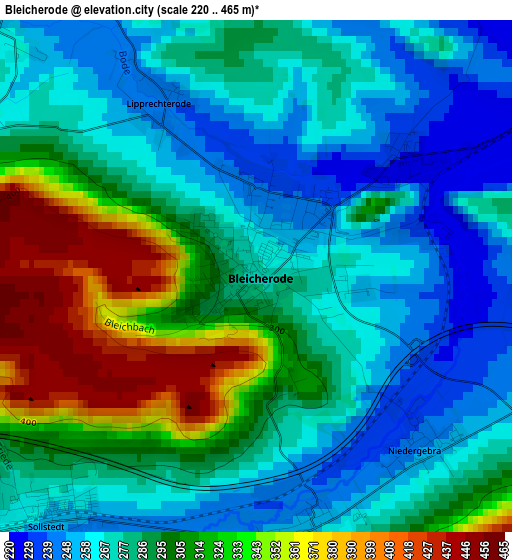
Below is the Elevation map of Bleicherode, which displays elevation range with different colors. Scale of the first map is from 220 to 465 m (722 to 1526 ft) with average elevation of 290.7 meters (=954 ft) [note 1]
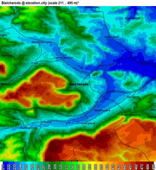
These maps also provides idea of topography and contour of this city, they are displayed at different zoom levels. More info about maps, scale and edge coordinates you can find below images.
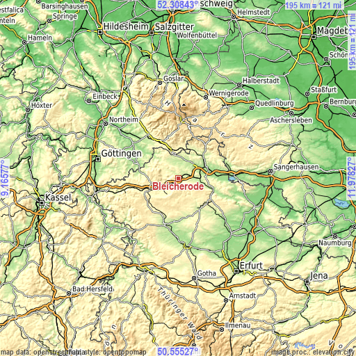
| \ | Map #1 | Map #2 | Topo.Map |
| Scale [m] | 220..465 m | 211..495 m | × |
| Scale [ft] | 722..1526 ft | 692..1624 ft | × |
| Average | 290.7 m = 954 ft | 313.9 m = 1030 ft | × |
| Width | 6.09 km = 3.8 mi | 12.18 km = 7.6 mi | 194.9 km = 121.1 mi |
| Height | 6.09 km = 3.8 mi | 12.18 km = 7.6 mi | 194.9 km = 121.1 mi |
| ↑Max Latitude | 51.467644° | 51.495012° | 52.30843° |
| Latitude at center | 51.44026° | 51.44026° | 51.44026° |
| ↓Min Latitude | 51.412859° | 51.385442° | 50.55527° |
| ← Min Longitude | 10.528075° | 10.484129° | 9.16577° |
| Longitude center | 10.57202° | 10.57202° | 10.57202° |
| →Max Longitude | 10.615965° | 10.659911° | 11.97827° |
Nearby cities:
Cities around Bleicherode sort by population:
• Worbis elevation 324 m
14.6 km,  261°
261°
• Niederorschel 278 m
12.8 km,  233°
233°
• Breitenworbis 299 m
10.4 km,  252°
252°
• Bischofferode 299 m
10.9 km,  305°
305°
• Gernrode 289 m
12.7 km, 249°
• Wipperdorf 219 m
5.3 km,  71°
71°
• Großbodungen 272 m
7.4 km,  302°
302°
• Kirchworbis 315 m
12.6 km, 255°
• Kleinfurra 201 m
13.6 km,  101°
101°
• Wolkramshausen 208 m
11.7 km, 100°
• Deuna 343 m
11.7 km,  215°
215°
• Kleinwenden 319 m
6.6 km,  113°
113°
Multilingual:
 En español:
Bleicherode elevación 270 m.
 En France:
Bleicherode élévation 270 m.
 Auf Deutsch:
Bleicherode höhe über dem Meeresspiegel ist 270 m.

Sources and notes:
- [note 1] Map square and city borders are not equal. Map elevation data is calculated only from area inside that square.
- [src 1] Elevation data from geonames database provided with same terms of usage.
- [src 2] The elevation map of Bleicherode is generated using elevation data from NASA's 3 arcsec (90m) resolution SRTM data.
- [src 3] Base (background) map © OpenStreetMap contributors tiles are generated by Geofabrik and OpenTopoMap.
Copyright & License:
This Bleicherode Elevation Map is licensed under CC BY-SA. You may reuse any part from this page, if you give a proper credit by linking to this URL:
 More info on terms of use page.