Kleinfurra elevation
Kleinfurra (Thuringia), Germany elevation is 201 meters and Kleinfurra elevation in feet is 659 ft above sea level [src 1]. Kleinfurra is a seat of a fourth-order administrative division (feature code) with elevation that is 57 meters (187 ft) smaller than average city elevation in Germany.
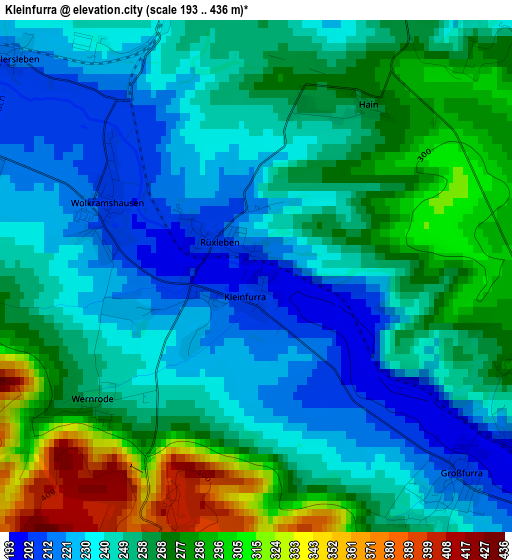
Below is the Elevation map of Kleinfurra, which displays elevation range with different colors. Scale of the first map is from 193 to 436 m (633 to 1430 ft) with average elevation of 256.2 meters (=841 ft) [note 1]
These maps also provides idea of topography and contour of this city, they are displayed at different zoom levels. More info about maps, scale and edge coordinates you can find below images.
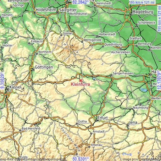
| \ | Map #1 | Topo.Map |
| Scale [m] | 193..436 m | × |
| Scale [ft] | 633..1430 ft | × |
| Average | 256.2 m = 841 ft | × |
| Width | 6.09 km = 3.8 mi | 195 km = 121.2 mi |
| Height | 6.09 km = 3.8 mi | 195 km = 121.2 mi |
| ↑Max Latitude | 51.442959° | 52.2842° |
| Latitude at center | 51.41556° | 51.41556° |
| ↓Min Latitude | 51.388145° | 50.5301° |
| ← Min Longitude | 10.720595° | 9.35829° |
| Longitude center | 10.76454° | 10.76454° |
| →Max Longitude | 10.808485° | 12.17079° |
Nearby cities:
Cities around Kleinfurra sort by population:
• Nordhausen elevation 208 m
9.8 km,  12°
12°
• Sondershausen 192 m
8.9 km,  124°
124°
• Bleicherode 270 m
13.6 km,  281°
281°
• Schernberg 334 m
9.8 km,  178°
178°
• Niedersachswerfen 214 m
15 km,  0°
0°
• Heringen 167 m
8.5 km,  65°
65°
• Wipperdorf 219 m
9.5 km,  298°
298°
• Uthleben 171 m
6.3 km,  53°
53°
• Wolkramshausen 208 m
2 km,  290°
290°
• Görsbach 164 m
13 km, 66°
• Auleben 172 m
11.5 km,  83°
83°
• Kleinwenden 319 m
7.3 km,  270°
270°
Multilingual:
 En español:
Kleinfurra elevación 201 m.
 En France:
Kleinfurra élévation 201 m.
 Auf Deutsch:
Kleinfurra höhe über dem Meeresspiegel ist 201 m.

Sources and notes:
- [note 1] Map square and city borders are not equal. Map elevation data is calculated only from area inside that square.
- [src 1] Elevation data from geonames database provided with same terms of usage.
- [src 2] The elevation map of Kleinfurra is generated using elevation data from NASA's 3 arcsec (90m) resolution SRTM data.
- [src 3] Base (background) map © OpenStreetMap contributors tiles are generated by Geofabrik and OpenTopoMap.
Copyright & License:
This Kleinfurra Elevation Map is licensed under CC BY-SA. You may reuse any part from this page, if you give a proper credit by linking to this URL:
 More info on terms of use page.