Görsbach elevation
Görsbach (Thuringia), Germany elevation is 164 meters and Görsbach elevation in feet is 538 ft above sea level [src 1]. Görsbach is a seat of a fourth-order administrative division (feature code) with elevation that is 94 meters (308 ft) smaller than average city elevation in Germany.
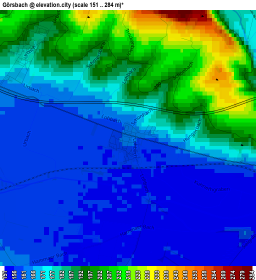
Below is the Elevation map of Görsbach, which displays elevation range with different colors. Scale of the first map is from 151 to 284 m (495 to 932 ft) with average elevation of 177 meters (=581 ft) [note 1]
These maps also provides idea of topography and contour of this city, they are displayed at different zoom levels. More info about maps, scale and edge coordinates you can find below images.
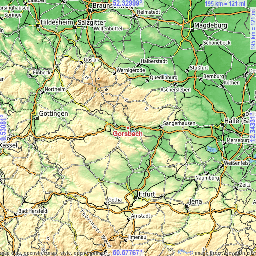
| \ | Map #1 | Topo.Map |
| Scale [m] | 151..284 m | × |
| Scale [ft] | 495..932 ft | × |
| Average | 177 m = 581 ft | × |
| Width | 6.09 km = 3.8 mi | 194.8 km = 121 mi |
| Height | 6.09 km = 3.8 mi | 194.8 km = 121 mi |
| ↑Max Latitude | 51.489611° | 52.32999° |
| Latitude at center | 51.46224° | 51.46224° |
| ↓Min Latitude | 51.434853° | 50.57767° |
| ← Min Longitude | 10.893115° | 9.53081° |
| Longitude center | 10.93706° | 10.93706° |
| →Max Longitude | 10.981005° | 12.34331° |
Nearby cities:
Cities around Görsbach sort by population:
• Nordhausen elevation 208 m
10.7 km,  294°
294°
• Sondershausen 192 m
11.3 km,  204°
204°
• Kelbra 163 m
7.8 km,  112°
112°
• Heringen 167 m
4.5 km,  248°
248°
• Roßla 155 m
9.6 km,  89°
89°
• Berga 160 m
4.9 km,  98°
98°
• Rottleberode 205 m
6.1 km,  6°
6°
• Stolberg 314 m
12.5 km, 5°
• Uthleben 171 m
7 km,  258°
258°
• Uftrungen 193 m
5 km,  36°
36°
• Auleben 172 m
4 km,  187°
187°
• Bennungen 148 m
12.5 km, 90°
Multilingual:
 En español:
Görsbach elevación 164 m.
 En France:
Görsbach élévation 164 m.
 Auf Deutsch:
Görsbach höhe über dem Meeresspiegel ist 164 m.

Sources and notes:
- [note 1] Map square and city borders are not equal. Map elevation data is calculated only from area inside that square.
- [src 1] Elevation data from geonames database provided with same terms of usage.
- [src 2] The elevation map of Görsbach is generated using elevation data from NASA's 3 arcsec (90m) resolution SRTM data.
- [src 3] Base (background) map © OpenStreetMap contributors tiles are generated by Geofabrik and OpenTopoMap.
Copyright & License:
This Görsbach Elevation Map is licensed under CC BY-SA. You may reuse any part from this page, if you give a proper credit by linking to this URL:
 More info on terms of use page.