Braunsbedra elevation
Braunsbedra (Saxony-Anhalt), Germany elevation is 118 meters and Braunsbedra elevation in feet is 387 ft above sea level [src 1]. Braunsbedra is a populated place (feature code) with elevation that is 140 meters (459 ft) smaller than average city elevation in Germany.
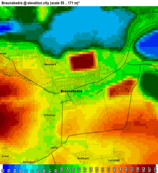
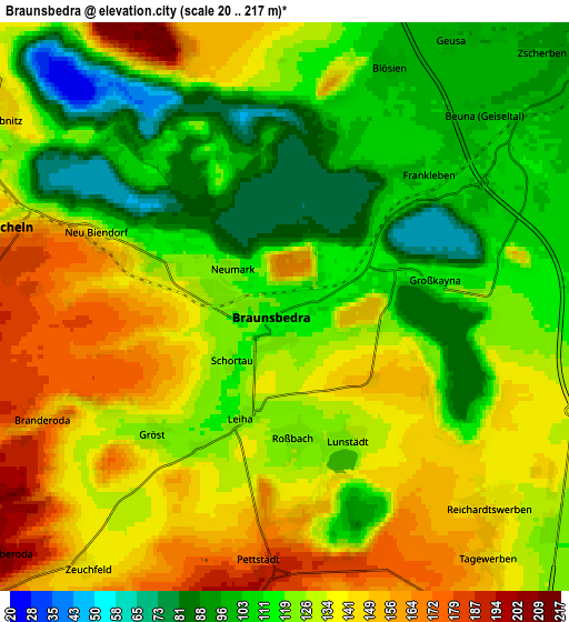
Below is the Elevation map of Braunsbedra, which displays elevation range with different colors. Scale of the first map is from 55 to 171 m (180 to 561 ft) with average elevation of 116.6 meters (=383 ft) [note 1]
These maps also provides idea of topography and contour of this city, they are displayed at different zoom levels. More info about maps, scale and edge coordinates you can find below images.
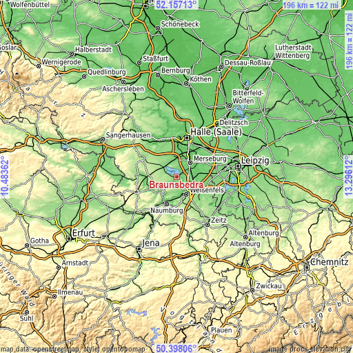
| \ | Map #1 | Map #2 | Topo.Map |
| Scale [m] | 55..171 m | 20..217 m | × |
| Scale [ft] | 180..561 ft | 66..712 ft | × |
| Average | 116.6 m = 383 ft | 126.4 m = 415 ft | × |
| Width | 6.11 km = 3.8 mi | 12.22 km = 7.6 mi | 195.6 km = 121.5 mi |
| Height | 6.11 km = 3.8 mi | 12.22 km = 7.6 mi | 195.6 km = 121.5 mi |
| ↑Max Latitude | 51.313497° | 51.340957° | 52.15713° |
| Latitude at center | 51.28602° | 51.28602° | 51.28602° |
| ↓Min Latitude | 51.258527° | 51.231017° | 50.39806° |
| ← Min Longitude | 11.845925° | 11.801979° | 10.48362° |
| Longitude center | 11.88987° | 11.88987° | 11.88987° |
| →Max Longitude | 11.933815° | 11.977761° | 13.29612° |
Nearby cities:
Cities around Braunsbedra sort by population:
• Leuna elevation 105 m
9.4 km,  68°
68°
• Mücheln 180 m
5.8 km,  281°
281°
• Frankleben 100 m
3.9 km,  44°
44°
• Zscherben 93 m
7.8 km,  45°
45°
• Geusa 97 m
7 km,  32°
32°
• Uichteritz 102 m
9.1 km,  165°
165°
• Reichardtswerben 140 m
6.1 km,  133°
133°
• Krumpa 123 m
3.4 km,  291°
291°
• Spergau 101 m
9.3 km,  84°
84°
• Großkayna 112 m
3 km, 80°
• Burgwerben 113 m
9.6 km,  137°
137°
• Beuna 104 m
5.4 km, 50°
Multilingual:
 En español:
Braunsbedra elevación 118 m.
 En France:
Braunsbedra élévation 118 m.
 Auf Deutsch:
Braunsbedra höhe über dem Meeresspiegel ist 118 m.

Sources and notes:
- [note 1] Map square and city borders are not equal. Map elevation data is calculated only from area inside that square.
- [src 1] Elevation data from geonames database provided with same terms of usage.
- [src 2] The elevation map of Braunsbedra is generated using elevation data from NASA's 3 arcsec (90m) resolution SRTM data.
- [src 3] Base (background) map © OpenStreetMap contributors tiles are generated by Geofabrik and OpenTopoMap.
Copyright & License:
This Braunsbedra Elevation Map is licensed under CC BY-SA. You may reuse any part from this page, if you give a proper credit by linking to this URL:
 More info on terms of use page.