Uichteritz elevation
Uichteritz (Saxony-Anhalt), Germany elevation is 102 meters and Uichteritz elevation in feet is 335 ft above sea level [src 1]. Uichteritz is a populated place (feature code) with elevation that is 156 meters (512 ft) smaller than average city elevation in Germany.
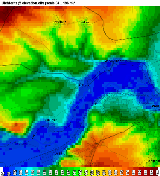
Below is the Elevation map of Uichteritz, which displays elevation range with different colors. Scale of the first map is from 94 to 196 m (308 to 643 ft) with average elevation of 134.4 meters (=441 ft) [note 1]
These maps also provides idea of topography and contour of this city, they are displayed at different zoom levels. More info about maps, scale and edge coordinates you can find below images.
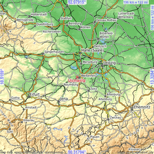
| \ | Map #1 | Topo.Map |
| Scale [m] | 94..196 m | × |
| Scale [ft] | 308..643 ft | × |
| Average | 134.4 m = 441 ft | × |
| Width | 6.12 km = 3.8 mi | 195.9 km = 121.7 mi |
| Height | 6.12 km = 3.8 mi | 195.9 km = 121.7 mi |
| ↑Max Latitude | 51.234044° | 52.07915° |
| Latitude at center | 51.20652° | 51.20652° |
| ↓Min Latitude | 51.178979° | 50.31704° |
| ← Min Longitude | 11.878205° | 10.5159° |
| Longitude center | 11.92215° | 11.92215° |
| →Max Longitude | 11.966095° | 13.3284° |
Nearby cities:
Cities around Uichteritz sort by population:
• Weißenfels elevation 102 m
3.3 km,  99°
99°
• Braunsbedra 118 m
9.1 km,  345°
345°
• Langendorf 143 m
4 km,  137°
137°
• Leißling 103 m
2.8 km,  198°
198°
• Reichardtswerben 140 m
5.2 km,  25°
25°
• Granschütz 149 m
9.3 km,  105°
105°
• Goseck 155 m
3.9 km,  259°
259°
• Schönburg 103 m
5.9 km,  221°
221°
• Großkayna 112 m
9.4 km,  4°
4°
• Burgwerben 113 m
4.7 km,  67°
67°
• Prittitz 167 m
6.3 km,  174°
174°
• Nessa 180 m
9.1 km, 138°
Multilingual:
 En español:
Uichteritz elevación 102 m.
 En France:
Uichteritz élévation 102 m.
 Auf Deutsch:
Uichteritz höhe über dem Meeresspiegel ist 102 m.

Sources and notes:
- [note 1] Map square and city borders are not equal. Map elevation data is calculated only from area inside that square.
- [src 1] Elevation data from geonames database provided with same terms of usage.
- [src 2] The elevation map of Uichteritz is generated using elevation data from NASA's 3 arcsec (90m) resolution SRTM data.
- [src 3] Base (background) map © OpenStreetMap contributors tiles are generated by Geofabrik and OpenTopoMap.
Copyright & License:
This Uichteritz Elevation Map is licensed under CC BY-SA. You may reuse any part from this page, if you give a proper credit by linking to this URL:
 More info on terms of use page.