Britten elevation
Britten (Saarland), Germany elevation is 367 meters and Britten elevation in feet is 1204 ft above sea level [src 1]. Britten is a populated place (feature code) with elevation that is 109 meters (358 ft) bigger than average city elevation in Germany.
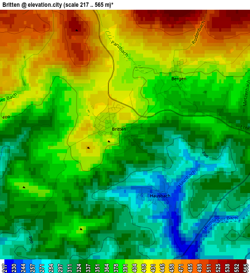
Below is the Elevation map of Britten, which displays elevation range with different colors. Scale of the first map is from 217 to 565 m (712 to 1854 ft) with average elevation of 372.6 meters (=1222 ft) [note 1]
These maps also provides idea of topography and contour of this city, they are displayed at different zoom levels. More info about maps, scale and edge coordinates you can find below images.
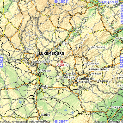
| \ | Map #1 | Topo.Map |
| Scale [m] | 217..565 m | × |
| Scale [ft] | 712..1854 ft | × |
| Average | 372.6 m = 1222 ft | × |
| Width | 6.34 km = 3.9 mi | 203 km = 126.1 mi |
| Height | 6.34 km = 3.9 mi | 203 km = 126.1 mi |
| ↑Max Latitude | 49.54913° | 50.42501° |
| Latitude at center | 49.52061° | 49.52061° |
| ↓Min Latitude | 49.492074° | 48.59917° |
| ← Min Longitude | 6.632565° | 5.27026° |
| Longitude center | 6.67651° | 6.67651° |
| →Max Longitude | 6.720455° | 8.08276° |
Nearby cities:
Cities around Britten sort by population:
• Merzig elevation 177 m
9 km,  197°
197°
• Losheim 296 m
5.1 km,  103°
103°
• Weiskirchen 352 m
10.6 km,  72°
72°
• Orscholz 412 m
11.1 km,  261°
261°
• Mettlach 161 m
7.2 km,  246°
246°
• Saarhölzbach 169 m
5 km, 263°
• Zerf 364 m
8.8 km,  3°
3°
• Serrig 165 m
9.5 km,  309°
309°
• Irsch 213 m
11 km,  328°
328°
• Freudenburg 371 m
10.7 km,  283°
283°
• Weiten 385 m
9.9 km, 276°
• Greimerath 436 m
4.6 km,  6°
6°
Multilingual:
 En español:
Britten elevación 367 m.
 En France:
Britten élévation 367 m.


Sources and notes:
- [note 1] Map square and city borders are not equal. Map elevation data is calculated only from area inside that square.
- [src 1] Elevation data from geonames database provided with same terms of usage.
- [src 2] The elevation map of Britten is generated using elevation data from NASA's 3 arcsec (90m) resolution SRTM data.
- [src 3] Base (background) map © OpenStreetMap contributors tiles are generated by Geofabrik and OpenTopoMap.
Copyright & License:
This Britten Elevation Map is licensed under CC BY-SA. You may reuse any part from this page, if you give a proper credit by linking to this URL:
 More info on terms of use page.