Burgpreppach elevation
Burgpreppach (Bavaria, Regierungsbezirk Unterfranken), Germany elevation is 303 meters and Burgpreppach elevation in feet is 994 ft above sea level [src 1]. Burgpreppach is a populated place (feature code) with elevation that is 45 meters (148 ft) bigger than average city elevation in Germany.
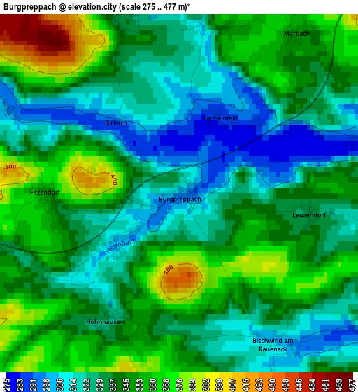
Below is the Elevation map of Burgpreppach, which displays elevation range with different colors. Scale of the first map is from 275 to 477 m (902 to 1565 ft) with average elevation of 339.1 meters (=1113 ft) [note 1]
These maps also provides idea of topography and contour of this city, they are displayed at different zoom levels. More info about maps, scale and edge coordinates you can find below images.
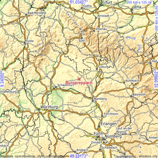
| \ | Map #1 | Topo.Map |
| Scale [m] | 275..477 m | × |
| Scale [ft] | 902..1565 ft | × |
| Average | 339.1 m = 1113 ft | × |
| Width | 6.26 km = 3.9 mi | 200.4 km = 124.5 mi |
| Height | 6.26 km = 3.9 mi | 200.4 km = 124.5 mi |
| ↑Max Latitude | 50.169646° | 51.03427° |
| Latitude at center | 50.14149° | 50.14149° |
| ↓Min Latitude | 50.113317° | 49.23173° |
| ← Min Longitude | 10.605825° | 9.24352° |
| Longitude center | 10.64977° | 10.64977° |
| →Max Longitude | 10.693715° | 12.05602° |
Nearby cities:
Cities around Burgpreppach sort by population:
• Haßfurt elevation 233 m
15.2 km,  219°
219°
• Zeil 235 m
15.2 km,  195°
195°
• Hofheim in Unterfranken 266 m
9 km,  266°
266°
• Seßlach 279 m
14.7 km,  68°
68°
• Maroldsweisach 333 m
6.1 km,  6°
6°
• Aidhausen 305 m
15.5 km, 273°
• Untermerzbach 266 m
14.8 km,  96°
96°
• Rentweinsdorf 265 m
13.7 km,  129°
129°
• Pfarrweisach 299 m
6 km,  80°
80°
• Kirchlauter 345 m
11.8 km,  155°
155°
• Hellingen 300 m
12.3 km, 11°
• Breitbrunn 294 m
14.3 km,  165°
165°
Multilingual:
 En español:
Burgpreppach elevación 303 m.
 En France:
Burgpreppach élévation 303 m.
 Auf Deutsch:
Burgpreppach höhe über dem Meeresspiegel ist 303 m.

Sources and notes:
- [note 1] Map square and city borders are not equal. Map elevation data is calculated only from area inside that square.
- [src 1] Elevation data from geonames database provided with same terms of usage.
- [src 2] The elevation map of Burgpreppach is generated using elevation data from NASA's 3 arcsec (90m) resolution SRTM data.
- [src 3] Base (background) map © OpenStreetMap contributors tiles are generated by Geofabrik and OpenTopoMap.
Copyright & License:
This Burgpreppach Elevation Map is licensed under CC BY-SA. You may reuse any part from this page, if you give a proper credit by linking to this URL:
 More info on terms of use page.