Cham elevation
Cham (Bavaria, Upper Palatinate), Germany elevation is 396 meters and Cham elevation in feet is 1299 ft above sea level [src 1]. Cham is a seat of a third-order administrative division (feature code) with elevation that is 138 meters (453 ft) bigger than average city elevation in Germany.
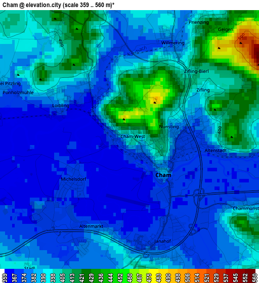
Below is the Elevation map of Cham, which displays elevation range with different colors. Scale of the first map is from 359 to 560 m (1178 to 1837 ft) with average elevation of 388.7 meters (=1275 ft) [note 1]
These maps also provides idea of topography and contour of this city, they are displayed at different zoom levels. More info about maps, scale and edge coordinates you can find below images.
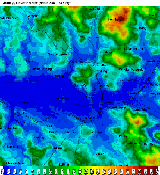
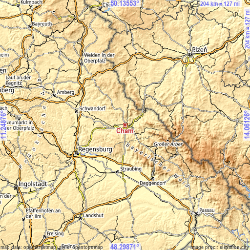
| \ | Map #1 | Map #2 | Topo.Map |
| Scale [m] | 359..560 m | 358..647 m | × |
| Scale [ft] | 1178..1837 ft | 1175..2123 ft | × |
| Average | 388.7 m = 1275 ft | 410.7 m = 1347 ft | × |
| Width | 6.38 km = 4 mi | 12.76 km = 7.9 mi | 204.2 km = 126.9 mi |
| Height | 6.38 km = 4 mi | 12.76 km = 7.9 mi | 204.2 km = 126.9 mi |
| ↑Max Latitude | 49.254342° | 49.283016° | 50.13553° |
| Latitude at center | 49.22565° | 49.22565° | 49.22565° |
| ↓Min Latitude | 49.196942° | 49.168217° | 48.29871° |
| ← Min Longitude | 12.611065° | 12.567119° | 11.24876° |
| Longitude center | 12.65501° | 12.65501° | 12.65501° |
| →Max Longitude | 12.698955° | 12.742901° | 14.06126° |
Nearby cities:
Cities around Cham sort by population:
• Roding elevation 380 m
10.4 km,  250°
250°
• Traitsching 416 m
8.4 km,  182°
182°
• Chamerau 373 m
7.5 km,  112°
112°
• Schorndorf 417 m
8.5 km,  211°
211°
• Weiding 380 m
8.9 km,  62°
62°
• Miltach 381 m
10.9 km,  130°
130°
• Runding 478 m
7.9 km,  98°
98°
• Stamsried 454 m
10.2 km,  297°
297°
• Pemfling 430 m
5.3 km,  328°
328°
• Willmering 392 m
2.8 km,  17°
17°
• Waffenbrunn 421 m
4.6 km,  10°
10°
• Zandt 456 m
10.2 km,  145°
145°
Multilingual:
 En español:
Cham elevación 396 m.
 En France:
Cham élévation 396 m.


Sources and notes:
- [note 1] Map square and city borders are not equal. Map elevation data is calculated only from area inside that square.
- [src 1] Elevation data from geonames database provided with same terms of usage.
- [src 2] The elevation map of Cham is generated using elevation data from NASA's 3 arcsec (90m) resolution SRTM data.
- [src 3] Base (background) map © OpenStreetMap contributors tiles are generated by Geofabrik and OpenTopoMap.
Copyright & License:
This Cham Elevation Map is licensed under CC BY-SA. You may reuse any part from this page, if you give a proper credit by linking to this URL:
 More info on terms of use page.