Roding elevation
Roding (Bavaria, Upper Palatinate), Germany elevation is 380 meters and Roding elevation in feet is 1247 ft above sea level [src 1]. Roding is a populated place (feature code) with elevation that is 122 meters (400 ft) bigger than average city elevation in Germany.
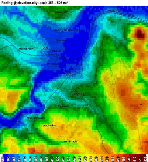
Below is the Elevation map of Roding, which displays elevation range with different colors. Scale of the first map is from 353 to 526 m (1158 to 1726 ft) with average elevation of 414.3 meters (=1359 ft) [note 1]
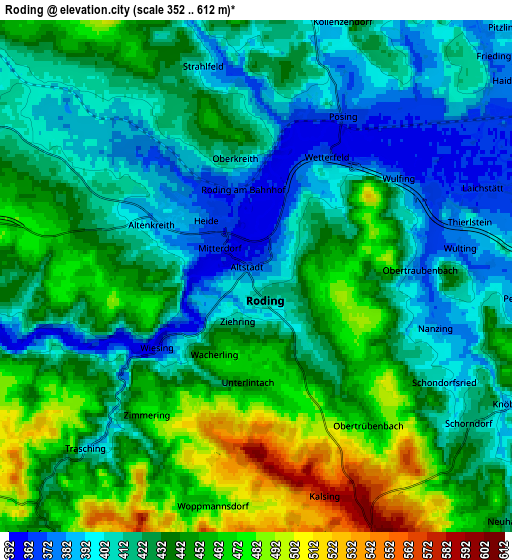
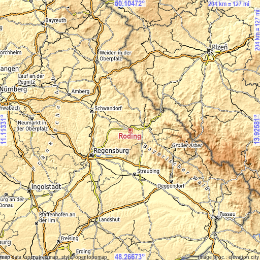
These maps also provides idea of topography and contour of this city, they are displayed at different zoom levels. More info about maps, scale and edge coordinates you can find below images.
| \ | Map #1 | Map #2 | Topo.Map |
| Scale [m] | 353..526 m | 352..612 m | × |
| Scale [ft] | 1158..1726 ft | 1155..2008 ft | × |
| Average | 414.3 m = 1359 ft | 430 m = 1411 ft | × |
| Width | 6.39 km = 4 mi | 12.77 km = 7.9 mi | 204.4 km = 127 mi |
| Height | 6.39 km = 4 mi | 12.77 km = 7.9 mi | 204.4 km = 127 mi |
| ↑Max Latitude | 49.22297° | 49.251663° | 50.10472° |
| Latitude at center | 49.19426° | 49.19426° | 49.19426° |
| ↓Min Latitude | 49.165534° | 49.13679° | 48.26673° |
| ← Min Longitude | 12.475615° | 12.431669° | 11.11331° |
| Longitude center | 12.51956° | 12.51956° | 12.51956° |
| →Max Longitude | 12.563505° | 12.607451° | 13.92581° |
Nearby cities:
Cities around Roding sort by population:
• Cham elevation 396 m
10.4 km,  70°
70°
• Traitsching 416 m
10.7 km,  117°
117°
• Falkenstein 566 m
11 km,  192°
192°
• Wald 552 m
13.3 km,  248°
248°
• Schorndorf 417 m
6.5 km,  125°
125°
• Stamsried 454 m
8.2 km,  5°
5°
• Pemfling 430 m
10.7 km,  41°
41°
• Willmering 392 m
12.4 km,  59°
59°
• Walderbach 352 m
10 km,  263°
263°
• Michelsneukirchen 562 m
8.3 km,  163°
163°
• Reichenbach 372 m
12.4 km, 264°
• Neukirchen-Balbini 507 m
12.3 km,  330°
330°
Multilingual:
 En español:
Roding elevación 380 m.
 En France:
Roding élévation 380 m.


Sources and notes:
- [note 1] Map square and city borders are not equal. Map elevation data is calculated only from area inside that square.
- [src 1] Elevation data from geonames database provided with same terms of usage.
- [src 2] The elevation map of Roding is generated using elevation data from NASA's 3 arcsec (90m) resolution SRTM data.
- [src 3] Base (background) map © OpenStreetMap contributors tiles are generated by Geofabrik and OpenTopoMap.
Copyright & License:
This Roding Elevation Map is licensed under CC BY-SA. You may reuse any part from this page, if you give a proper credit by linking to this URL:
 More info on terms of use page.