Georgenberg elevation
Georgenberg (Bavaria, Upper Palatinate), Germany elevation is 601 meters and Georgenberg elevation in feet is 1972 ft above sea level [src 1]. Georgenberg is a seat of a fourth-order administrative division (feature code) with elevation that is 343 meters (1125 ft) bigger than average city elevation in Germany.
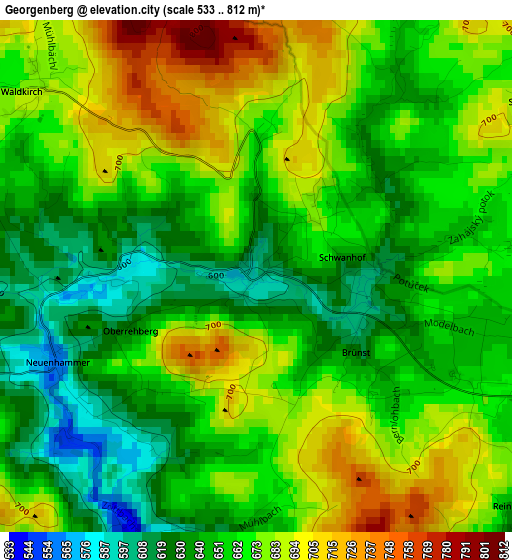
Below is the Elevation map of Georgenberg, which displays elevation range with different colors. Scale of the first map is from 533 to 812 m (1749 to 2664 ft) with average elevation of 663.3 meters (=2176 ft) [note 1]
These maps also provides idea of topography and contour of this city, they are displayed at different zoom levels. More info about maps, scale and edge coordinates you can find below images.
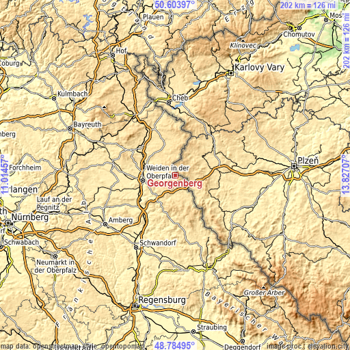
| \ | Map #1 | Topo.Map |
| Scale [m] | 533..812 m | × |
| Scale [ft] | 1749..2664 ft | × |
| Average | 663.3 m = 2176 ft | × |
| Width | 6.32 km = 3.9 mi | 202.3 km = 125.7 mi |
| Height | 6.32 km = 3.9 mi | 202.2 km = 125.6 mi |
| ↑Max Latitude | 49.731383° | 50.60397° |
| Latitude at center | 49.70297° | 49.70297° |
| ↓Min Latitude | 49.67454° | 48.78495° |
| ← Min Longitude | 12.376875° | 11.01457° |
| Longitude center | 12.42082° | 12.42082° |
| →Max Longitude | 12.464765° | 13.82707° |
Nearby cities:
Cities around Georgenberg sort by population:
• Vohenstrauß elevation 553 m
10.6 km,  214°
214°
• Floß 479 m
10.7 km,  282°
282°
• Bärnau 608 m
12 km,  4°
4°
• Eslarn 514 m
15.1 km,  151°
151°
• Pleystein 523 m
6.1 km,  189°
189°
• Moosbach 499 m
12.7 km,  183°
183°
• Waidhaus 526 m
8.6 km,  141°
141°
• Waldthurn 554 m
7.4 km,  242°
242°
• Konradsreuth 520 m
9.9 km,  295°
295°
• Flossenbürg 644 m
6.1 km, 303°
• Püchersreuth 494 m
14.5 km,  291°
291°
• Theisseil 545 m
14 km,  264°
264°
Multilingual:
 En español:
Georgenberg elevación 601 m.
 En France:
Georgenberg élévation 601 m.
 Auf Deutsch:
Georgenberg höhe über dem Meeresspiegel ist 601 m.

Sources and notes:
- [note 1] Map square and city borders are not equal. Map elevation data is calculated only from area inside that square.
- [src 1] Elevation data from geonames database provided with same terms of usage.
- [src 2] The elevation map of Georgenberg is generated using elevation data from NASA's 3 arcsec (90m) resolution SRTM data.
- [src 3] Base (background) map © OpenStreetMap contributors tiles are generated by Geofabrik and OpenTopoMap.
Copyright & License:
This Georgenberg Elevation Map is licensed under CC BY-SA. You may reuse any part from this page, if you give a proper credit by linking to this URL:
 More info on terms of use page.