Eslarn elevation
Eslarn (Bavaria, Upper Palatinate), Germany elevation is 514 meters and Eslarn elevation in feet is 1686 ft above sea level [src 1]. Eslarn is a populated place (feature code) with elevation that is 256 meters (840 ft) bigger than average city elevation in Germany.
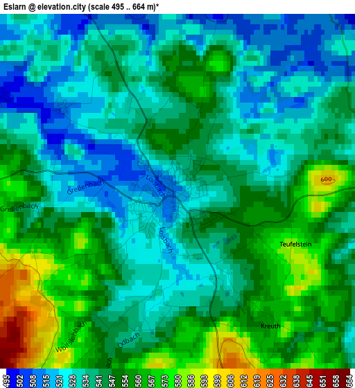
Below is the Elevation map of Eslarn, which displays elevation range with different colors. Scale of the first map is from 495 to 664 m (1624 to 2178 ft) with average elevation of 542.8 meters (=1781 ft) [note 1]
These maps also provides idea of topography and contour of this city, they are displayed at different zoom levels. More info about maps, scale and edge coordinates you can find below images.
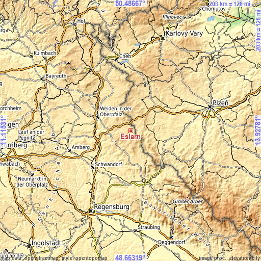
| \ | Map #1 | Topo.Map |
| Scale [m] | 495..664 m | × |
| Scale [ft] | 1624..2178 ft | × |
| Average | 542.8 m = 1781 ft | × |
| Width | 6.34 km = 3.9 mi | 202.8 km = 126 mi |
| Height | 6.34 km = 3.9 mi | 202.7 km = 126 mi |
| ↑Max Latitude | 49.611933° | 50.48667° |
| Latitude at center | 49.58345° | 49.58345° |
| ↓Min Latitude | 49.55495° | 48.66319° |
| ← Min Longitude | 12.477615° | 11.11531° |
| Longitude center | 12.52156° | 12.52156° |
| →Max Longitude | 12.565505° | 13.92781° |
Nearby cities:
Cities around Eslarn sort by population:
• Vohenstrauß elevation 553 m
14 km,  288°
288°
• Oberviechtach 506 m
15.9 km,  208°
208°
• Pleystein 523 m
11.1 km,  311°
311°
• Schönsee 653 m
8.3 km,  166°
166°
• Moosbach 499 m
8 km,  274°
274°
• Waidhaus 526 m
6.8 km,  343°
343°
• Waldthurn 554 m
17 km, 305°
• Teunz 470 m
14.9 km,  221°
221°
• Tännesberg 602 m
15.1 km,  247°
247°
• Georgenberg 601 m
15.1 km,  331°
331°
• Winklarn 523 m
17.7 km,  189°
189°
• Niedermurach 420 m
18.2 km, 215°
Multilingual:
 En español:
Eslarn elevación 514 m.
 En France:
Eslarn élévation 514 m.


Sources and notes:
- [note 1] Map square and city borders are not equal. Map elevation data is calculated only from area inside that square.
- [src 1] Elevation data from geonames database provided with same terms of usage.
- [src 2] The elevation map of Eslarn is generated using elevation data from NASA's 3 arcsec (90m) resolution SRTM data.
- [src 3] Base (background) map © OpenStreetMap contributors tiles are generated by Geofabrik and OpenTopoMap.
Copyright & License:
This Eslarn Elevation Map is licensed under CC BY-SA. You may reuse any part from this page, if you give a proper credit by linking to this URL:
 More info on terms of use page.