Grevenbroich elevation
Grevenbroich (North Rhine-Westphalia, Düsseldorf District), Germany elevation is 52 meters and Grevenbroich elevation in feet is 171 ft above sea level [src 1]. Grevenbroich is a populated place (feature code) with elevation that is 206 meters (676 ft) smaller than average city elevation in Germany.
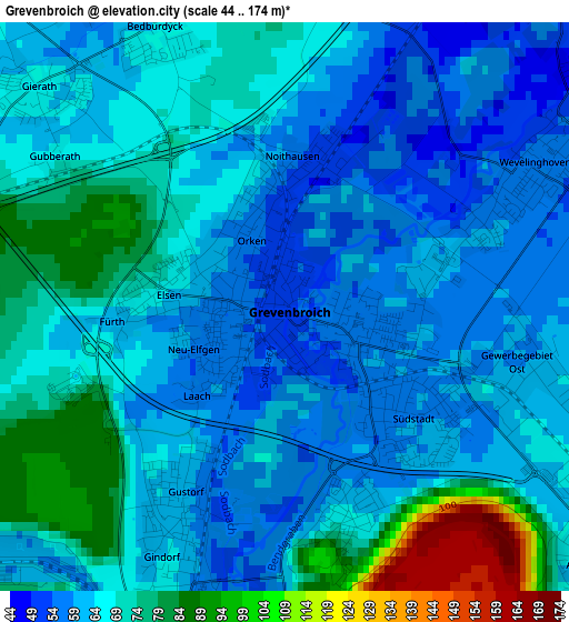
Below is the Elevation map of Grevenbroich, which displays elevation range with different colors. Scale of the first map is from 44 to 174 m (144 to 571 ft) with average elevation of 66.3 meters (=218 ft) [note 1]
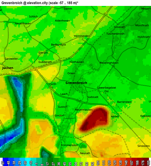
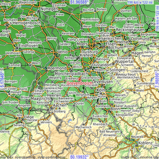
These maps also provides idea of topography and contour of this city, they are displayed at different zoom levels. More info about maps, scale and edge coordinates you can find below images.
| \ | Map #1 | Map #2 | Topo.Map |
| Scale [m] | 44..174 m | -57..185 m | × |
| Scale [ft] | 144..571 ft | -187..607 ft | × |
| Average | 66.3 m = 218 ft | 64.5 m = 212 ft | × |
| Width | 6.14 km = 3.8 mi | 12.28 km = 7.6 mi | 196.4 km = 122 mi |
| Height | 6.14 km = 3.8 mi | 12.28 km = 7.6 mi | 196.4 km = 122 mi |
| ↑Max Latitude | 51.118613° | 51.14619° | 51.96585° |
| Latitude at center | 51.09102° | 51.09102° | 51.09102° |
| ↓Min Latitude | 51.06341° | 51.035784° | 50.19932° |
| ← Min Longitude | 6.538755° | 6.494809° | 5.17645° |
| Longitude center | 6.5827° | 6.5827° | 6.5827° |
| →Max Longitude | 6.626645° | 6.670591° | 7.98895° |
Nearby cities:
Cities around Grevenbroich sort by population:
• Mönchengladbach elevation 57 m
14.4 km,  316°
316°
• Neuss 44 m
13.9 km,  30°
30°
• Dormagen 45 m
17.4 km,  87°
87°
• Bergheim 67 m
15.6 km,  165°
165°
• Neubrück 51 m
6.2 km,  38°
38°
• Kaarst 42 m
15.6 km,  9°
9°
• Korschenbroich 48 m
12.2 km,  336°
336°
• Bedburg 62 m
11 km,  184°
184°
• Jüchen 75 m
5.9 km,  279°
279°
• Elsdorf 78 m
17.1 km, 183°
• Rommerskirchen 74 m
9.5 km,  132°
132°
• Titz 102 m
14.5 km,  229°
229°
Multilingual:
 En español:
Grevenbroich elevación 52 m.
 En France:
Grevenbroich élévation 52 m.
 Auf Deutsch:
Grevenbroich höhe über dem Meeresspiegel ist 52 m.

Sources and notes:
- [note 1] Map square and city borders are not equal. Map elevation data is calculated only from area inside that square.
- [src 1] Elevation data from geonames database provided with same terms of usage.
- [src 2] The elevation map of Grevenbroich is generated using elevation data from NASA's 3 arcsec (90m) resolution SRTM data.
- [src 3] Base (background) map © OpenStreetMap contributors tiles are generated by Geofabrik and OpenTopoMap.
Copyright & License:
This Grevenbroich Elevation Map is licensed under CC BY-SA. You may reuse any part from this page, if you give a proper credit by linking to this URL:
 More info on terms of use page.