Kaarst elevation
Kaarst (North Rhine-Westphalia, Düsseldorf District), Germany elevation is 42 meters and Kaarst elevation in feet is 138 ft above sea level [src 1]. Kaarst is a populated place (feature code) with elevation that is 216 meters (709 ft) smaller than average city elevation in Germany.
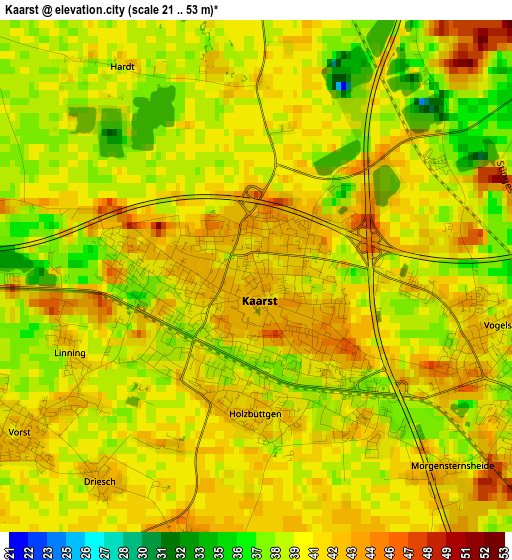
Below is the Elevation map of Kaarst, which displays elevation range with different colors. Scale of the first map is from 21 to 53 m (69 to 174 ft) with average elevation of 40.2 meters (=132 ft) [note 1]
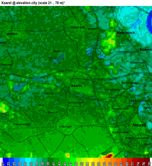
These maps also provides idea of topography and contour of this city, they are displayed at different zoom levels. More info about maps, scale and edge coordinates you can find below images.
| \ | Map #1 | Map #2 | Topo.Map |
| Scale [m] | 21..53 m | 21..78 m | × |
| Scale [ft] | 69..174 ft | 69..256 ft | × |
| Average | 40.2 m = 132 ft | 40.1 m = 132 ft | × |
| Width | 6.12 km = 3.8 mi | 12.24 km = 7.6 mi | 195.8 km = 121.7 mi |
| Height | 6.12 km = 3.8 mi | 12.24 km = 7.6 mi | 195.8 km = 121.7 mi |
| ↑Max Latitude | 51.256801° | 51.284295° | 52.10149° |
| Latitude at center | 51.22929° | 51.22929° | 51.22929° |
| ↓Min Latitude | 51.201763° | 51.17422° | 50.34024° |
| ← Min Longitude | 6.574885° | 6.530939° | 5.21258° |
| Longitude center | 6.61883° | 6.61883° | 6.61883° |
| →Max Longitude | 6.662775° | 6.706721° | 8.02508° |
Nearby cities:
Cities around Kaarst sort by population:
• Düsseldorf elevation 45 m
11 km,  94°
94°
• Mönchengladbach 57 m
13.3 km,  248°
248°
• Krefeld 43 m
12.7 km,  339°
339°
• Neuss 44 m
5.8 km,  126°
126°
• Viersen 44 m
15.9 km,  280°
280°
• Grevenbroich 52 m
15.6 km,  189°
189°
• Meerbusch 34 m
5.5 km,  61°
61°
• Willich 43 m
6.3 km,  307°
307°
• Neubrück 51 m
10.6 km,  172°
172°
• Korschenbroich 48 m
8.5 km,  240°
240°
• Tönisvorst 42 m
13.4 km,  319°
319°
• Düsseldorf-Pempelfort 43 m
11.7 km, 85°
Multilingual:
 En español:
Kaarst elevación 42 m.
 En France:
Kaarst élévation 42 m.


Sources and notes:
- [note 1] Map square and city borders are not equal. Map elevation data is calculated only from area inside that square.
- [src 1] Elevation data from geonames database provided with same terms of usage.
- [src 2] The elevation map of Kaarst is generated using elevation data from NASA's 3 arcsec (90m) resolution SRTM data.
- [src 3] Base (background) map © OpenStreetMap contributors tiles are generated by Geofabrik and OpenTopoMap.
Copyright & License:
This Kaarst Elevation Map is licensed under CC BY-SA. You may reuse any part from this page, if you give a proper credit by linking to this URL:
 More info on terms of use page.