Großlangheim elevation
Großlangheim (Bavaria, Regierungsbezirk Unterfranken), Germany elevation is 226 meters and Großlangheim elevation in feet is 741 ft above sea level [src 1]. Großlangheim is a populated place (feature code) with elevation that is 32 meters (105 ft) smaller than average city elevation in Germany.
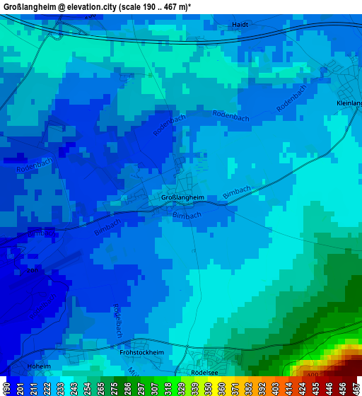
Below is the Elevation map of Großlangheim, which displays elevation range with different colors. Scale of the first map is from 190 to 467 m (623 to 1532 ft) with average elevation of 229.1 meters (=752 ft) [note 1]
These maps also provides idea of topography and contour of this city, they are displayed at different zoom levels. More info about maps, scale and edge coordinates you can find below images.
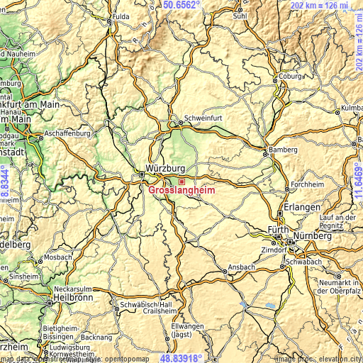
| \ | Map #1 | Topo.Map |
| Scale [m] | 190..467 m | × |
| Scale [ft] | 623..1532 ft | × |
| Average | 229.1 m = 752 ft | × |
| Width | 6.31 km = 3.9 mi | 202 km = 125.5 mi |
| Height | 6.31 km = 3.9 mi | 202 km = 125.5 mi |
| ↑Max Latitude | 49.784582° | 50.6562° |
| Latitude at center | 49.7562° | 49.7562° |
| ↓Min Latitude | 49.727801° | 48.83918° |
| ← Min Longitude | 10.196705° | 8.8344° |
| Longitude center | 10.24065° | 10.24065° |
| →Max Longitude | 10.284595° | 11.6469° |
Nearby cities:
Cities around Großlangheim sort by population:
• Kitzingen elevation 201 m
6.7 km,  254°
254°
• Dettelbach 205 m
7.5 km,  313°
313°
• Wiesentheid 249 m
8.6 km,  60°
60°
• Iphofen 256 m
6.1 km,  166°
166°
• Mainbernheim 221 m
5.6 km,  196°
196°
• Albertshofen 193 m
5.4 km,  282°
282°
• Mainstockheim 207 m
6.9 km, 284°
• Kleinlangheim 228 m
3.5 km, 62°
• Willanzheim 257 m
8.5 km,  183°
183°
• Rödelsee 241 m
3.1 km, 176°
• Sommerach 199 m
8.5 km,  343°
343°
• Buchbrunn 247 m
7.5 km,  273°
273°
Multilingual:
 En español:
Großlangheim elevación 226 m.
 En France:
Großlangheim élévation 226 m.
 Auf Deutsch:
Großlangheim höhe über dem Meeresspiegel ist 226 m.

Sources and notes:
- [note 1] Map square and city borders are not equal. Map elevation data is calculated only from area inside that square.
- [src 1] Elevation data from geonames database provided with same terms of usage.
- [src 2] The elevation map of Großlangheim is generated using elevation data from NASA's 3 arcsec (90m) resolution SRTM data.
- [src 3] Base (background) map © OpenStreetMap contributors tiles are generated by Geofabrik and OpenTopoMap.
Copyright & License:
This Großlangheim Elevation Map is licensed under CC BY-SA. You may reuse any part from this page, if you give a proper credit by linking to this URL:
 More info on terms of use page.