Iphofen elevation
Iphofen (Bavaria, Regierungsbezirk Unterfranken), Germany elevation is 256 meters and Iphofen elevation in feet is 840 ft above sea level [src 1]. Iphofen is a populated place (feature code) with elevation that is 2 meters (7 ft) smaller than average city elevation in Germany.
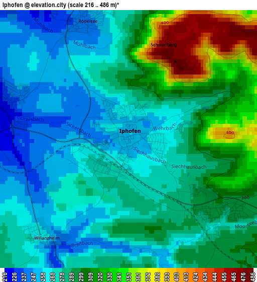
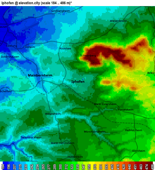
Below is the Elevation map of Iphofen, which displays elevation range with different colors. Scale of the first map is from 216 to 486 m (709 to 1594 ft) with average elevation of 288.9 meters (=948 ft) [note 1]
These maps also provides idea of topography and contour of this city, they are displayed at different zoom levels. More info about maps, scale and edge coordinates you can find below images.
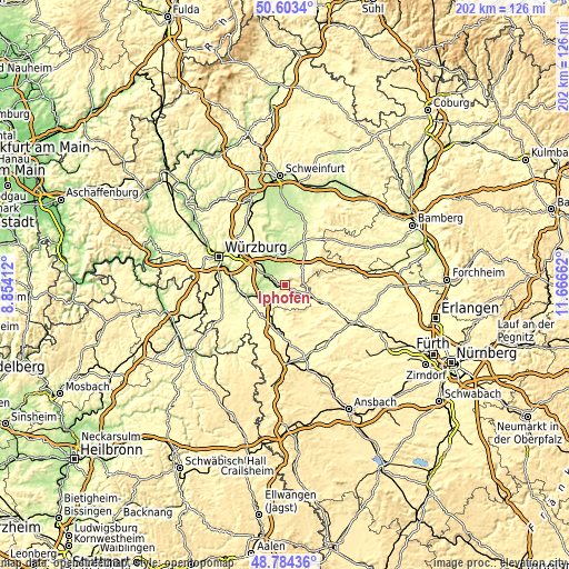
| \ | Map #1 | Map #2 | Topo.Map |
| Scale [m] | 216..486 m | 184..486 m | × |
| Scale [ft] | 709..1594 ft | 604..1594 ft | × |
| Average | 288.9 m = 948 ft | 277.6 m = 911 ft | × |
| Width | 6.32 km = 3.9 mi | 12.64 km = 7.9 mi | 202.3 km = 125.7 mi |
| Height | 6.32 km = 3.9 mi | 12.64 km = 7.9 mi | 202.2 km = 125.6 mi |
| ↑Max Latitude | 49.730804° | 49.759201° | 50.6034° |
| Latitude at center | 49.70239° | 49.70239° | 49.70239° |
| ↓Min Latitude | 49.67396° | 49.645513° | 48.78436° |
| ← Min Longitude | 10.216425° | 10.172479° | 8.85412° |
| Longitude center | 10.26037° | 10.26037° | 10.26037° |
| →Max Longitude | 10.304315° | 10.348261° | 11.66662° |
Nearby cities:
Cities around Iphofen sort by population:
• Kitzingen elevation 201 m
8.9 km,  297°
297°
• Marktbreit 191 m
9.1 km,  243°
243°
• Mainbernheim 221 m
3 km,  281°
281°
• Obernbreit 199 m
8.5 km,  234°
234°
• Marktsteft 192 m
9 km,  265°
265°
• Kleinlangheim 228 m
7.8 km,  12°
12°
• Willanzheim 257 m
3.2 km,  219°
219°
• Großlangheim 226 m
6.1 km,  346°
346°
• Rödelsee 241 m
3.1 km,  337°
337°
• Sulzfeld am Main 187 m
9.2 km, 273°
• Markt Einersheim 290 m
2.8 km,  128°
128°
• Seinsheim 248 m
7.4 km,  202°
202°
Multilingual:
 En español:
Iphofen elevación 256 m.
 En France:
Iphofen élévation 256 m.


Sources and notes:
- [note 1] Map square and city borders are not equal. Map elevation data is calculated only from area inside that square.
- [src 1] Elevation data from geonames database provided with same terms of usage.
- [src 2] The elevation map of Iphofen is generated using elevation data from NASA's 3 arcsec (90m) resolution SRTM data.
- [src 3] Base (background) map © OpenStreetMap contributors tiles are generated by Geofabrik and OpenTopoMap.
Copyright & License:
This Iphofen Elevation Map is licensed under CC BY-SA. You may reuse any part from this page, if you give a proper credit by linking to this URL:
 More info on terms of use page.