Gundersheim elevation
Gundersheim (Rheinland-Pfalz), Germany elevation is 148 meters and Gundersheim elevation in feet is 486 ft above sea level [src 1]. Gundersheim is a seat of a fourth-order administrative division (feature code) with elevation that is 110 meters (361 ft) smaller than average city elevation in Germany.
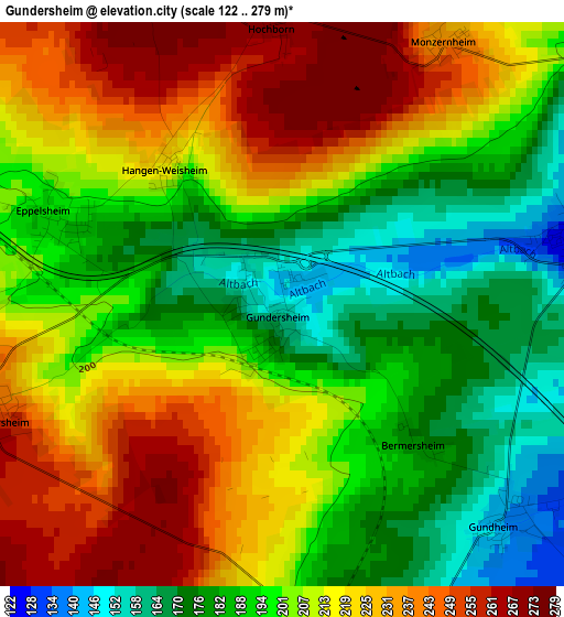
Below is the Elevation map of Gundersheim, which displays elevation range with different colors. Scale of the first map is from 122 to 279 m (400 to 915 ft) with average elevation of 206 meters (=676 ft) [note 1]
These maps also provides idea of topography and contour of this city, they are displayed at different zoom levels. More info about maps, scale and edge coordinates you can find below images.
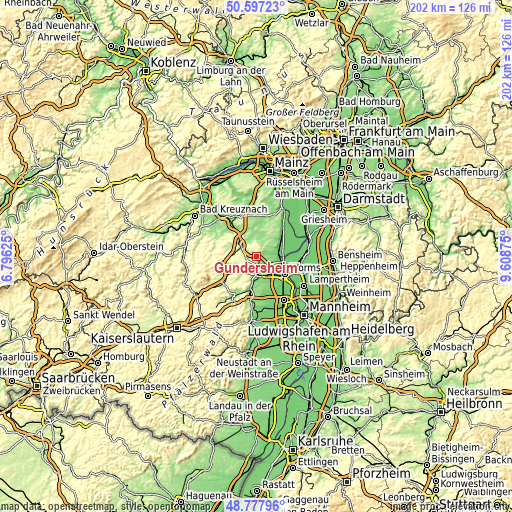
| \ | Map #1 | Topo.Map |
| Scale [m] | 122..279 m | × |
| Scale [ft] | 400..915 ft | × |
| Average | 206 m = 676 ft | × |
| Width | 6.32 km = 3.9 mi | 202.3 km = 125.7 mi |
| Height | 6.32 km = 3.9 mi | 202.3 km = 125.7 mi |
| ↑Max Latitude | 49.724527° | 50.59723° |
| Latitude at center | 49.69611° | 49.69611° |
| ↓Min Latitude | 49.667676° | 48.77796° |
| ← Min Longitude | 8.158555° | 6.79625° |
| Longitude center | 8.2025° | 8.2025° |
| →Max Longitude | 8.246445° | 9.60875° |
Nearby cities:
Cities around Gundersheim sort by population:
• Alzey elevation 173 m
8.4 km,  311°
311°
• Osthofen 99 m
8.8 km,  84°
84°
• Westhofen 127 m
3.4 km,  74°
74°
• Monsheim 133 m
6.6 km,  174°
174°
• Dittelsheim-Heßloch 169 m
5.9 km,  24°
24°
• Bechtheim 138 m
7.3 km,  61°
61°
• Albisheim 177 m
9.4 km,  236°
236°
• Framersheim 159 m
7.2 km,  343°
343°
• Eppelsheim 194 m
2.9 km,  291°
291°
• Ober-Flörsheim 266 m
3.7 km,  246°
246°
• Flomborn 251 m
3.9 km,  260°
260°
• Kindenheim 224 m
9.8 km,  196°
196°
Multilingual:
 En español:
Gundersheim elevación 148 m.
 En France:
Gundersheim élévation 148 m.
 Auf Deutsch:
Gundersheim höhe über dem Meeresspiegel ist 148 m.

Sources and notes:
- [note 1] Map square and city borders are not equal. Map elevation data is calculated only from area inside that square.
- [src 1] Elevation data from geonames database provided with same terms of usage.
- [src 2] The elevation map of Gundersheim is generated using elevation data from NASA's 3 arcsec (90m) resolution SRTM data.
- [src 3] Base (background) map © OpenStreetMap contributors tiles are generated by Geofabrik and OpenTopoMap.
Copyright & License:
This Gundersheim Elevation Map is licensed under CC BY-SA. You may reuse any part from this page, if you give a proper credit by linking to this URL:
 More info on terms of use page.