Hettenleidelheim elevation
Hettenleidelheim (Rheinland-Pfalz), Germany elevation is 251 meters and Hettenleidelheim elevation in feet is 823 ft above sea level [src 1]. Hettenleidelheim is a seat of a fourth-order administrative division (feature code) with elevation that is 7 meters (23 ft) smaller than average city elevation in Germany.
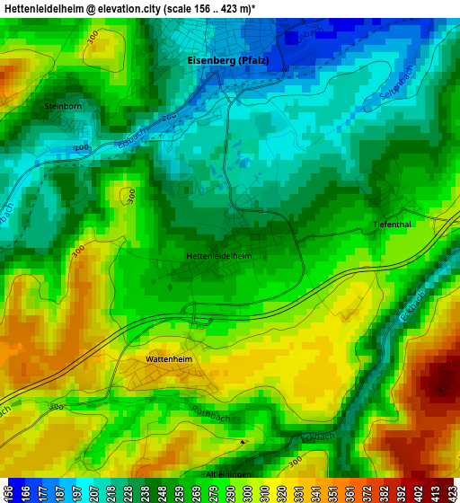
Below is the Elevation map of Hettenleidelheim, which displays elevation range with different colors. Scale of the first map is from 156 to 423 m (512 to 1388 ft) with average elevation of 268.5 meters (=881 ft) [note 1]
These maps also provides idea of topography and contour of this city, they are displayed at different zoom levels. More info about maps, scale and edge coordinates you can find below images.
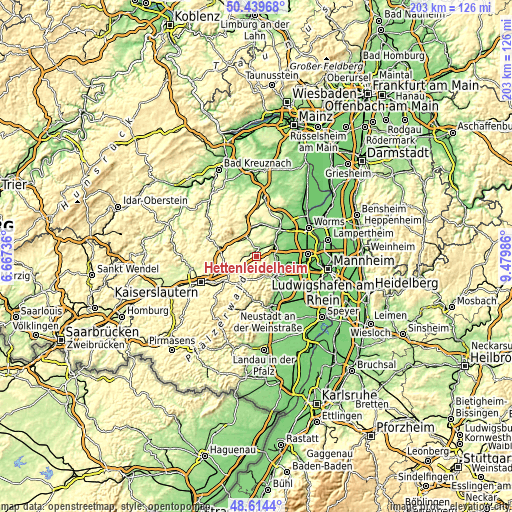
| \ | Map #1 | Topo.Map |
| Scale [m] | 156..423 m | × |
| Scale [ft] | 512..1388 ft | × |
| Average | 268.5 m = 881 ft | × |
| Width | 6.34 km = 3.9 mi | 203 km = 126.1 mi |
| Height | 6.34 km = 3.9 mi | 202.9 km = 126.1 mi |
| ↑Max Latitude | 49.564071° | 50.43968° |
| Latitude at center | 49.53556° | 49.53556° |
| ↓Min Latitude | 49.507032° | 48.6144° |
| ← Min Longitude | 8.029665° | 6.66736° |
| Longitude center | 8.07361° | 8.07361° |
| →Max Longitude | 8.117555° | 9.47986° |
Nearby cities:
Cities around Hettenleidelheim sort by population:
• Grünstadt elevation 177 m
7.1 km,  64°
64°
• Herxheim am Berg 203 m
8.2 km,  111°
111°
• Eisenberg 188 m
2.6 km,  357°
357°
• Göllheim 247 m
6.8 km,  346°
346°
• Carlsberg 330 m
4.2 km,  213°
213°
• Rodenbach 173 m
4.9 km,  29°
29°
• Kerzenheim 258 m
4.6 km, 347°
• Altleiningen 241 m
3.1 km,  180°
180°
• Ramsen 216 m
4.4 km,  272°
272°
• Kirchheim an der Weinstraße 164 m
7.7 km,  88°
88°
• Wattenheim 328 m
1.8 km, 209°
• Ebertsheim 173 m
4.4 km, 34°
Multilingual:
 En español:
Hettenleidelheim elevación 251 m.
 En France:
Hettenleidelheim élévation 251 m.
 Auf Deutsch:
Hettenleidelheim höhe über dem Meeresspiegel ist 251 m.

Sources and notes:
- [note 1] Map square and city borders are not equal. Map elevation data is calculated only from area inside that square.
- [src 1] Elevation data from geonames database provided with same terms of usage.
- [src 2] The elevation map of Hettenleidelheim is generated using elevation data from NASA's 3 arcsec (90m) resolution SRTM data.
- [src 3] Base (background) map © OpenStreetMap contributors tiles are generated by Geofabrik and OpenTopoMap.
Copyright & License:
This Hettenleidelheim Elevation Map is licensed under CC BY-SA. You may reuse any part from this page, if you give a proper credit by linking to this URL:
 More info on terms of use page.