Grünstadt elevation
Grünstadt (Rheinland-Pfalz), Germany elevation is 177 meters and Grünstadt elevation in feet is 581 ft above sea level [src 1]. Grünstadt is a populated place (feature code) with elevation that is 81 meters (266 ft) smaller than average city elevation in Germany.
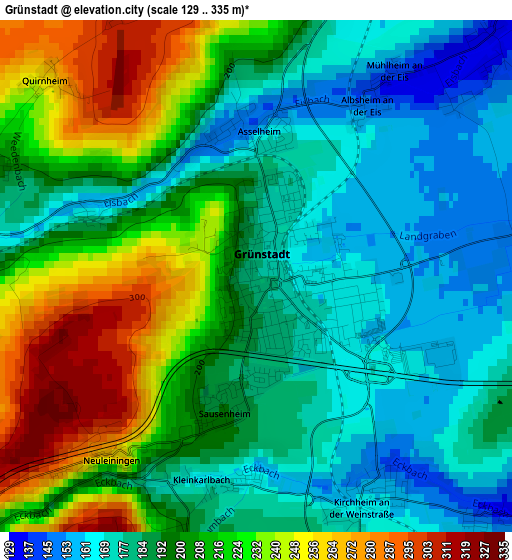
Below is the Elevation map of Grünstadt, which displays elevation range with different colors. Scale of the first map is from 129 to 335 m (423 to 1099 ft) with average elevation of 200.9 meters (=659 ft) [note 1]
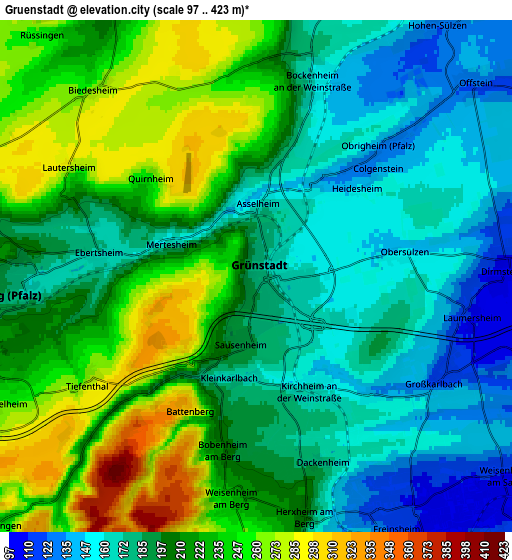
These maps also provides idea of topography and contour of this city, they are displayed at different zoom levels. More info about maps, scale and edge coordinates you can find below images.
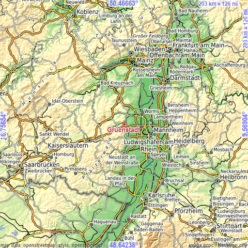
| \ | Map #1 | Map #2 | Topo.Map |
| Scale [m] | 129..335 m | 97..423 m | × |
| Scale [ft] | 423..1099 ft | 318..1388 ft | × |
| Average | 200.9 m = 659 ft | 204.7 m = 672 ft | × |
| Width | 6.34 km = 3.9 mi | 12.68 km = 7.9 mi | 202.8 km = 126 mi |
| Height | 6.34 km = 3.9 mi | 12.68 km = 7.9 mi | 202.8 km = 126 mi |
| ↑Max Latitude | 49.591515° | 49.619994° | 50.46663° |
| Latitude at center | 49.56302° | 49.56302° | 49.56302° |
| ↓Min Latitude | 49.534508° | 49.50598° | 48.64238° |
| ← Min Longitude | 8.118845° | 8.074899° | 6.75654° |
| Longitude center | 8.16279° | 8.16279° | 8.16279° |
| →Max Longitude | 8.206735° | 8.250681° | 9.56904° |
Nearby cities:
Cities around Grünstadt sort by population:
• Herxheim am Berg elevation 203 m
6.1 km,  168°
168°
• Eisenberg 188 m
6.6 km,  265°
265°
• Heidesheim 143 m
3.2 km,  47°
47°
• Rodenbach 173 m
4.2 km,  287°
287°
• Dirmstein 106 m
5.9 km,  89°
89°
• Hettenleidelheim 251 m
7.1 km,  244°
244°
• Obrigheim 133 m
4.4 km,  43°
43°
• Bockenheim 156 m
5.1 km,  18°
18°
• Kirchheim an der Weinstraße 164 m
3.2 km,  155°
155°
• Ebertsheim 173 m
4 km,  278°
278°
• Großkarlbach 122 m
5.2 km,  121°
121°
• Kindenheim 224 m
5.3 km,  1°
1°
Multilingual:
 En español:
Grünstadt elevación 177 m.
 En France:
Grünstadt élévation 177 m.
 Auf Deutsch:
Grünstadt höhe über dem Meeresspiegel ist 177 m.

Sources and notes:
- [note 1] Map square and city borders are not equal. Map elevation data is calculated only from area inside that square.
- [src 1] Elevation data from geonames database provided with same terms of usage.
- [src 2] The elevation map of Grünstadt is generated using elevation data from NASA's 3 arcsec (90m) resolution SRTM data.
- [src 3] Base (background) map © OpenStreetMap contributors tiles are generated by Geofabrik and OpenTopoMap.
Copyright & License:
This Grünstadt Elevation Map is licensed under CC BY-SA. You may reuse any part from this page, if you give a proper credit by linking to this URL:
 More info on terms of use page.