Irschenberg elevation
Irschenberg (Bavaria, Upper Bavaria), Germany elevation is 729 meters and Irschenberg elevation in feet is 2392 ft above sea level [src 1]. Irschenberg is a seat of a fourth-order administrative division (feature code) with elevation that is 471 meters (1545 ft) bigger than average city elevation in Germany.
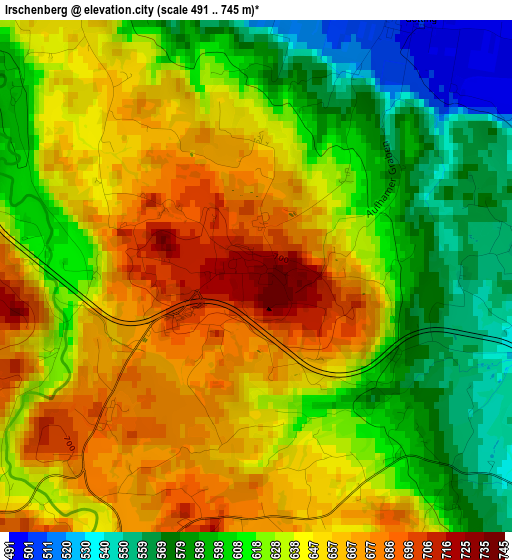
Below is the Elevation map of Irschenberg, which displays elevation range with different colors. Scale of the first map is from 491 to 745 m (1611 to 2444 ft) with average elevation of 629.7 meters (=2066 ft) [note 1]
These maps also provides idea of topography and contour of this city, they are displayed at different zoom levels. More info about maps, scale and edge coordinates you can find below images.
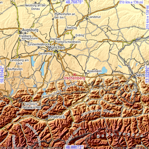
| \ | Map #1 | Topo.Map |
| Scale [m] | 491..745 m | × |
| Scale [ft] | 1611..2444 ft | × |
| Average | 629.7 m = 2066 ft | × |
| Width | 6.56 km = 4.1 mi | 209.9 km = 130.4 mi |
| Height | 6.56 km = 4.1 mi | 209.9 km = 130.4 mi |
| ↑Max Latitude | 47.862822° | 48.76875° |
| Latitude at center | 47.83333° | 47.83333° |
| ↓Min Latitude | 47.803822° | 46.88073° |
| ← Min Longitude | 11.872725° | 10.51042° |
| Longitude center | 11.91667° | 11.91667° |
| →Max Longitude | 11.960615° | 13.32292° |
Nearby cities:
Cities around Irschenberg sort by population:
• Kolbermoor elevation 461 m
11.4 km,  80°
80°
• Bad Aibling 482 m
7.8 km,  64°
64°
• Bruckmühl 514 m
5.1 km,  355°
355°
• Miesbach 700 m
7.9 km,  231°
231°
• Feldkirchen-Westerham 553 m
9.9 km,  326°
326°
• Hausham 771 m
11.2 km,  210°
210°
• Bad Feilnbach 520 m
9.6 km,  133°
133°
• Schliersee 787 m
11.6 km,  201°
201°
• Fischbachau 774 m
12.9 km,  168°
168°
• Weyarn 673 m
9.2 km,  287°
287°
• Valley 650 m
12.2 km,  302°
302°
• Vagen 527 m
5.1 km, 332°
Multilingual:
 En español:
Irschenberg elevación 729 m.
 En France:
Irschenberg élévation 729 m.
 Auf Deutsch:
Irschenberg höhe über dem Meeresspiegel ist 729 m.

Sources and notes:
- [note 1] Map square and city borders are not equal. Map elevation data is calculated only from area inside that square.
- [src 1] Elevation data from geonames database provided with same terms of usage.
- [src 2] The elevation map of Irschenberg is generated using elevation data from NASA's 3 arcsec (90m) resolution SRTM data.
- [src 3] Base (background) map © OpenStreetMap contributors tiles are generated by Geofabrik and OpenTopoMap.
Copyright & License:
This Irschenberg Elevation Map is licensed under CC BY-SA. You may reuse any part from this page, if you give a proper credit by linking to this URL:
 More info on terms of use page.