Schliersee elevation
Schliersee (Bavaria, Upper Bavaria), Germany elevation is 787 meters and Schliersee elevation in feet is 2582 ft above sea level [src 1]. Schliersee is a populated place (feature code) with elevation that is 529 meters (1736 ft) bigger than average city elevation in Germany.
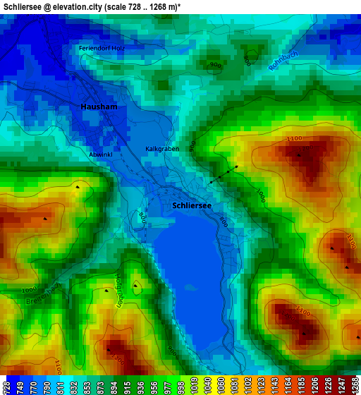
Below is the Elevation map of Schliersee, which displays elevation range with different colors. Scale of the first map is from 728 to 1268 m (2388 to 4160 ft) with average elevation of 916.8 meters (=3008 ft) [note 1]
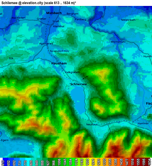
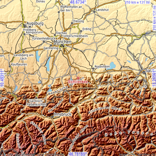
These maps also provides idea of topography and contour of this city, they are displayed at different zoom levels. More info about maps, scale and edge coordinates you can find below images.
| \ | Map #1 | Map #2 | Topo.Map |
| Scale [m] | 728..1268 m | 613..1634 m | × |
| Scale [ft] | 2388..4160 ft | 2011..5361 ft | × |
| Average | 916.8 m = 3008 ft | 904.8 m = 2969 ft | × |
| Width | 6.57 km = 4.1 mi | 13.14 km = 8.2 mi | 210.3 km = 130.7 mi |
| Height | 6.57 km = 4.1 mi | 13.14 km = 8.2 mi | 210.3 km = 130.7 mi |
| ↑Max Latitude | 47.765757° | 47.795287° | 48.6734° |
| Latitude at center | 47.73621° | 47.73621° | 47.73621° |
| ↓Min Latitude | 47.706646° | 47.677066° | 46.78185° |
| ← Min Longitude | 11.815415° | 11.771469° | 10.45311° |
| Longitude center | 11.85936° | 11.85936° | 11.85936° |
| →Max Longitude | 11.903305° | 11.947251° | 13.26561° |
Nearby cities:
Cities around Schliersee sort by population:
• Miesbach elevation 700 m
6.2 km,  341°
341°
• Hausham 771 m
1.8 km,  309°
309°
• Bad Feilnbach 520 m
12 km,  69°
69°
• Gmund am Tegernsee 739 m
9.2 km,  280°
280°
• Fischbachau 774 m
7.1 km,  105°
105°
• Waakirchen 767 m
14.5 km,  286°
286°
• Rottach-Egern 738 m
8.4 km,  232°
232°
• Bad Wiessee 751 m
10.9 km,  258°
258°
• Tegernsee 759 m
8 km,  250°
250°
• Weyarn 673 m
14.3 km, 341°
• Irschenberg 729 m
11.6 km,  21°
21°
• Bayrischzell 803 m
13.5 km,  120°
120°
Multilingual:
 En español:
Schliersee elevación 787 m.
 En France:
Schliersee élévation 787 m.
 Auf Deutsch:
Schliersee höhe über dem Meeresspiegel ist 787 m.

Sources and notes:
- [note 1] Map square and city borders are not equal. Map elevation data is calculated only from area inside that square.
- [src 1] Elevation data from geonames database provided with same terms of usage.
- [src 2] The elevation map of Schliersee is generated using elevation data from NASA's 3 arcsec (90m) resolution SRTM data.
- [src 3] Base (background) map © OpenStreetMap contributors tiles are generated by Geofabrik and OpenTopoMap.
Copyright & License:
This Schliersee Elevation Map is licensed under CC BY-SA. You may reuse any part from this page, if you give a proper credit by linking to this URL:
 More info on terms of use page.