Karlsruhe elevation
Karlsruhe (Baden-Württemberg, Karlsruhe Region), Germany elevation is 118 meters and Karlsruhe elevation in feet is 387 ft above sea level [src 1]. Karlsruhe is a seat of a second-order administrative division (feature code) with elevation that is 140 meters (459 ft) smaller than average city elevation in Germany.
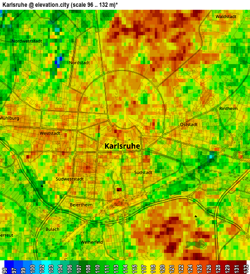
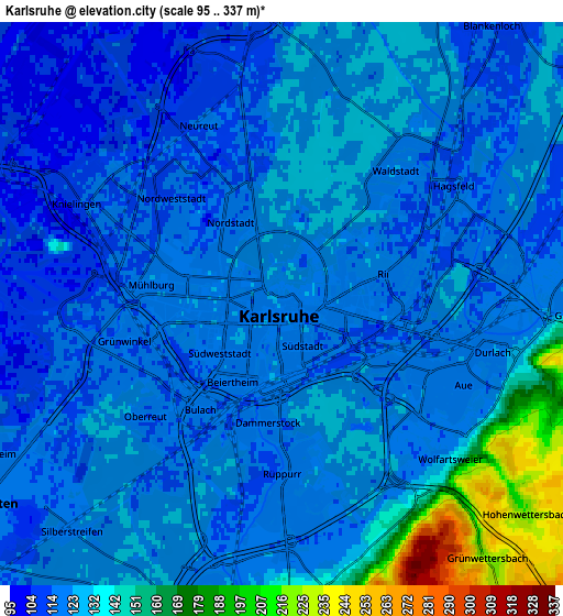
Below is the Elevation map of Karlsruhe, which displays elevation range with different colors. Scale of the first map is from 96 to 132 m (315 to 433 ft) with average elevation of 117.4 meters (=385 ft) [note 1]
These maps also provides idea of topography and contour of this city, they are displayed at different zoom levels. More info about maps, scale and edge coordinates you can find below images.
| \ | Map #1 | Map #2 | Topo.Map |
| Scale [m] | 96..132 m | 95..337 m | × |
| Scale [ft] | 315..433 ft | 312..1106 ft | × |
| Average | 117.4 m = 385 ft | 126.1 m = 414 ft | × |
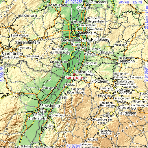
| Width | 6.41 km = 4 mi | 12.82 km = 8 mi | 205.1 km = 127.4 mi |
| Height | 6.41 km = 4 mi | 12.82 km = 8 mi | 205.1 km = 127.4 mi |
| ↑Max Latitude | 49.038187° | 49.066987° | 49.92325° |
| Latitude at center | 49.00937° | 49.00937° | 49.00937° |
| ↓Min Latitude | 48.980536° | 48.951686° | 48.0784° |
| ← Min Longitude | 8.360495° | 8.316549° | 6.99819° |
| Longitude center | 8.40444° | 8.40444° | 8.40444° |
| →Max Longitude | 8.448385° | 8.492331° | 9.81069° |
Nearby cities:
Cities around Karlsruhe sort by population:
• Ettlingen elevation 139 m
7.6 km,  178°
178°
• Rheinstetten 114 m
8.4 km,  237°
237°
• Wörth am Rhein 116 m
11.4 km,  292°
292°
• Eggenstein-Leopoldshafen 110 m
9 km,  357°
357°
• Durmersheim 107 m
13.1 km,  229°
229°
• Linkenheim-Hochstetten 106 m
13.6 km,  2°
2°
• Weingarten 115 m
10.2 km,  60°
60°
• Jockgrim 114 m
13.3 km,  314°
314°
• Hagenbach 108 m
11.3 km,  274°
274°
• Jöhlingen 160 m
12.6 km,  78°
78°
• Leimersheim 103 m
13.5 km,  341°
341°
• Neuburg 110 m
11.7 km,  259°
259°
Multilingual:
 En español:
Karlsruhe elevación 118 m.
 En France:
Karlsruhe élévation 118 m.
 Auf Deutsch:
Karlsruhe höhe über dem Meeresspiegel ist 118 m.

Sources and notes:
- [note 1] Map square and city borders are not equal. Map elevation data is calculated only from area inside that square.
- [src 1] Elevation data from geonames database provided with same terms of usage.
- [src 2] The elevation map of Karlsruhe is generated using elevation data from NASA's 3 arcsec (90m) resolution SRTM data.
- [src 3] Base (background) map © OpenStreetMap contributors tiles are generated by Geofabrik and OpenTopoMap.
Copyright & License:
This Karlsruhe Elevation Map is licensed under CC BY-SA. You may reuse any part from this page, if you give a proper credit by linking to this URL:
 More info on terms of use page.