Ettlingen elevation
Ettlingen (Baden-Württemberg, Karlsruhe Region), Germany elevation is 139 meters and Ettlingen elevation in feet is 456 ft above sea level [src 1]. Ettlingen is a populated place (feature code) with elevation that is 119 meters (390 ft) smaller than average city elevation in Germany.
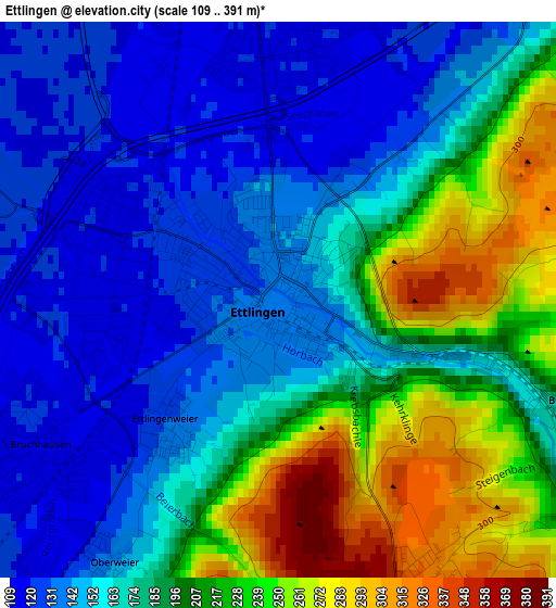
Below is the Elevation map of Ettlingen, which displays elevation range with different colors. Scale of the first map is from 109 to 391 m (358 to 1283 ft) with average elevation of 182.2 meters (=598 ft) [note 1]
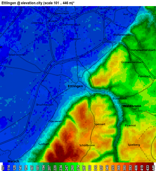
These maps also provides idea of topography and contour of this city, they are displayed at different zoom levels. More info about maps, scale and edge coordinates you can find below images.
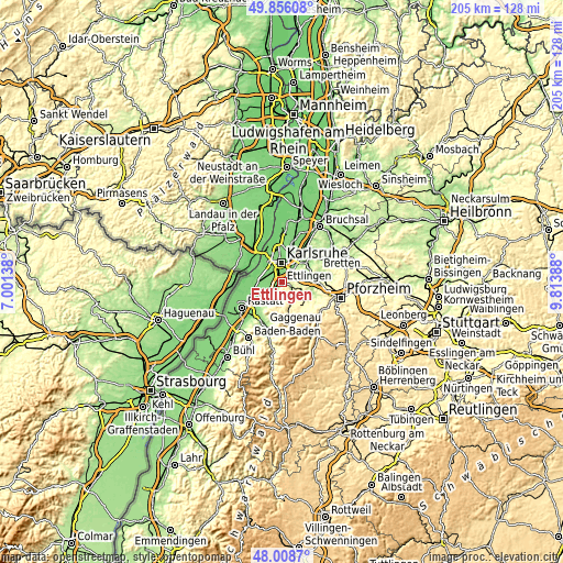
| \ | Map #1 | Map #2 | Topo.Map |
| Scale [m] | 109..391 m | 101..446 m | × |
| Scale [ft] | 358..1283 ft | 331..1463 ft | × |
| Average | 182.2 m = 598 ft | 194.1 m = 637 ft | × |
| Width | 6.42 km = 4 mi | 12.84 km = 8 mi | 205.4 km = 127.6 mi |
| Height | 6.42 km = 4 mi | 12.84 km = 8 mi | 205.4 km = 127.6 mi |
| ↑Max Latitude | 48.969797° | 48.998636° | 49.85608° |
| Latitude at center | 48.94094° | 48.94094° | 48.94094° |
| ↓Min Latitude | 48.912067° | 48.883177° | 48.0087° |
| ← Min Longitude | 8.363685° | 8.319739° | 7.00138° |
| Longitude center | 8.40763° | 8.40763° | 8.40763° |
| →Max Longitude | 8.451575° | 8.495521° | 9.81388° |
Nearby cities:
Cities around Ettlingen sort by population:
• Karlsruhe elevation 118 m
7.6 km,  358°
358°
• Rheinstetten 114 m
8 km,  292°
292°
• Malsch 127 m
8.4 km,  220°
220°
• Durmersheim 107 m
10.3 km,  265°
265°
• Königsbach-Stein 169 m
14.7 km,  79°
79°
• Muggensturm 116 m
12.3 km,  227°
227°
• Bietigheim 119 m
11.9 km,  252°
252°
• Hagenbach 108 m
14.3 km,  306°
306°
• Ötigheim 121 m
13.8 km, 246°
• Au am Rhein 107 m
12.8 km, 274°
• Bischweier 136 m
14.6 km, 218°
• Neuburg 110 m
12.9 km, 294°
Multilingual:
 En español:
Ettlingen elevación 139 m.
 En France:
Ettlingen élévation 139 m.
 Auf Deutsch:
Ettlingen höhe über dem Meeresspiegel ist 139 m.

Sources and notes:
- [note 1] Map square and city borders are not equal. Map elevation data is calculated only from area inside that square.
- [src 1] Elevation data from geonames database provided with same terms of usage.
- [src 2] The elevation map of Ettlingen is generated using elevation data from NASA's 3 arcsec (90m) resolution SRTM data.
- [src 3] Base (background) map © OpenStreetMap contributors tiles are generated by Geofabrik and OpenTopoMap.
Copyright & License:
This Ettlingen Elevation Map is licensed under CC BY-SA. You may reuse any part from this page, if you give a proper credit by linking to this URL:
 More info on terms of use page.