Kehl elevation
Kehl (Baden-Württemberg, Freiburg Region), Germany elevation is 138 meters and Kehl elevation in feet is 453 ft above sea level [src 1]. Kehl is a populated place (feature code) with elevation that is 120 meters (394 ft) smaller than average city elevation in Germany.
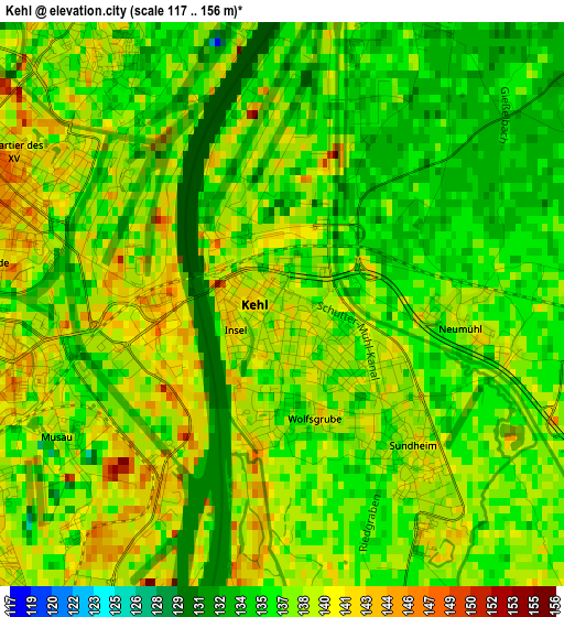
Below is the Elevation map of Kehl, which displays elevation range with different colors. Scale of the first map is from 117 to 156 m (384 to 512 ft) with average elevation of 137 meters (=449 ft) [note 1]
These maps also provides idea of topography and contour of this city, they are displayed at different zoom levels. More info about maps, scale and edge coordinates you can find below images.
| \ | Map #1 | Map #2 | Topo.Map |
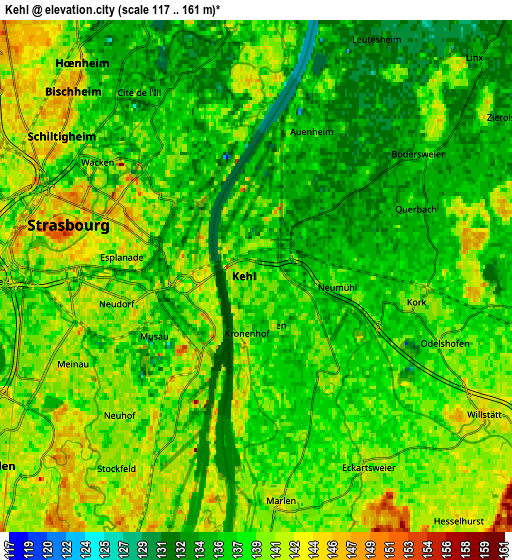
| Scale [m] | 117..156 m | 117..161 m | × |
| Scale [ft] | 384..512 ft | 384..528 ft | × |
| Average | 137 m = 449 ft | 138.3 m = 454 ft | × |
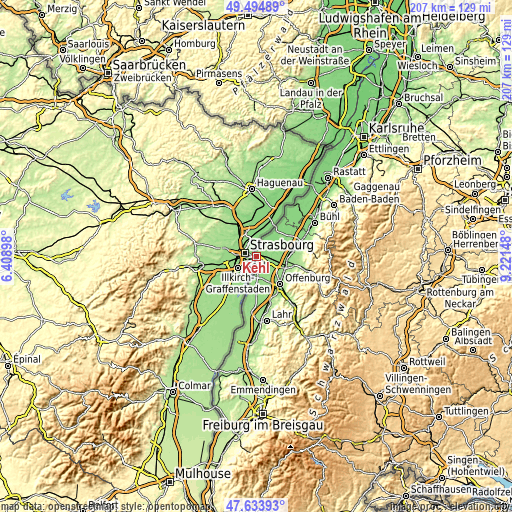
| Width | 6.47 km = 4 mi | 12.93 km = 8 mi | 206.9 km = 128.6 mi |
| Height | 6.47 km = 4 mi | 12.93 km = 8 mi | 206.9 km = 128.6 mi |
| ↑Max Latitude | 48.602039° | 48.631091° | 49.49489° |
| Latitude at center | 48.57297° | 48.57297° | 48.57297° |
| ↓Min Latitude | 48.543885° | 48.514782° | 47.63393° |
| ← Min Longitude | 7.771285° | 7.727339° | 6.40898° |
| Longitude center | 7.81523° | 7.81523° | 7.81523° |
| →Max Longitude | 7.859175° | 7.903121° | 9.22148° |
Nearby cities:
Cities around Kehl sort by population:
• Offenburg elevation 163 m
14.6 km,  139°
139°
• Achern 145 m
20.2 km,  71°
71°
• Oberkirch 193 m
19.9 km,  103°
103°
• Rheinau 131 m
13.7 km,  40°
40°
• Willstätt 145 m
6.8 km,  122°
122°
• Schutterwald 150 m
14.6 km,  159°
159°
• Renchen 147 m
14.7 km,  83°
83°
• Haslach 178 m
17.8 km,  92°
92°
• Durbach 214 m
17.3 km, 120°
• Meißenheim 147 m
18.4 km,  189°
189°
• Ortenberg 166 m
17.8 km, 139°
• Lautenbach 301 m
18.6 km, 122°
Multilingual:
 En español:
Kehl elevación 138 m.
 En France:
Kehl élévation 138 m.


Sources and notes:
- [note 1] Map square and city borders are not equal. Map elevation data is calculated only from area inside that square.
- [src 1] Elevation data from geonames database provided with same terms of usage.
- [src 2] The elevation map of Kehl is generated using elevation data from NASA's 3 arcsec (90m) resolution SRTM data.
- [src 3] Base (background) map © OpenStreetMap contributors tiles are generated by Geofabrik and OpenTopoMap.
Copyright & License:
This Kehl Elevation Map is licensed under CC BY-SA. You may reuse any part from this page, if you give a proper credit by linking to this URL:
 More info on terms of use page.