Kirchheim unter Teck elevation
Kirchheim unter Teck (Baden-Württemberg, Regierungsbezirk Stuttgart), Germany elevation is 316 meters and Kirchheim unter Teck elevation in feet is 1037 ft above sea level [src 1]. Kirchheim unter Teck is a populated place (feature code) with elevation that is 58 meters (190 ft) bigger than average city elevation in Germany.
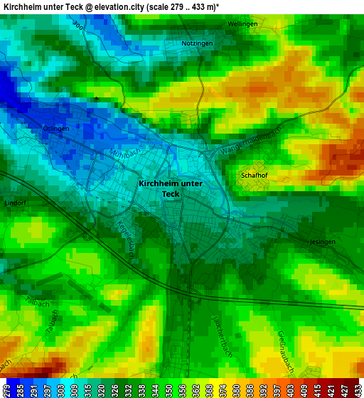
Below is the Elevation map of Kirchheim unter Teck, which displays elevation range with different colors. Scale of the first map is from 279 to 433 m (915 to 1421 ft) with average elevation of 339.9 meters (=1115 ft) [note 1]
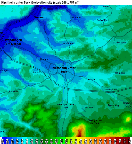
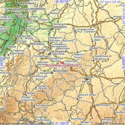
These maps also provides idea of topography and contour of this city, they are displayed at different zoom levels. More info about maps, scale and edge coordinates you can find below images.
| \ | Map #1 | Map #2 | Topo.Map |
| Scale [m] | 279..433 m | 246..757 m | × |
| Scale [ft] | 915..1421 ft | 807..2484 ft | × |
| Average | 339.9 m = 1115 ft | 355.5 m = 1166 ft | × |
| Width | 6.46 km = 4 mi | 12.91 km = 8 mi | 206.6 km = 128.4 mi |
| Height | 6.46 km = 4 mi | 12.91 km = 8 mi | 206.6 km = 128.4 mi |
| ↑Max Latitude | 48.675856° | 48.704866° | 49.56739° |
| Latitude at center | 48.64683° | 48.64683° | 48.64683° |
| ↓Min Latitude | 48.617787° | 48.588727° | 47.70915° |
| ← Min Longitude | 9.409835° | 9.365889° | 8.04753° |
| Longitude center | 9.45378° | 9.45378° | 9.45378° |
| →Max Longitude | 9.497725° | 9.541671° | 10.86003° |
Nearby cities:
Cities around Kirchheim unter Teck sort by population:
• Wendlingen am Neckar elevation 268 m
6.3 km,  295°
295°
• Wernau 260 m
5.9 km,  331°
331°
• Reichenbach an der Fils 261 m
7.1 km,  6°
6°
• Dettingen unter Teck 352 m
3.4 km,  184°
184°
• Oberboihingen 271 m
6.4 km,  273°
273°
• Hochdorf 281 m
5.2 km, 9°
• Schlierbach 351 m
5.6 km,  57°
57°
• Bissingen an der Teck 418 m
6 km,  152°
152°
• Owen 389 m
6.6 km, 182°
• Notzingen 314 m
2.7 km, 5°
• Holzmaden 356 m
4.9 km,  107°
107°
• Ohmden 360 m
5.4 km,  90°
90°
Multilingual:
 En español:
Kirchheim unter Teck elevación 316 m.
 En France:
Kirchheim unter Teck élévation 316 m.
 Auf Deutsch:
Kirchheim unter Teck höhe über dem Meeresspiegel ist 316 m.
 На русском:
Кирхгайм-унтер-Тек, Кирххайм-унтер-Текк высота над уровнем моря 316 м
Sources and notes:
- [note 1] Map square and city borders are not equal. Map elevation data is calculated only from area inside that square.
- [src 1] Elevation data from geonames database provided with same terms of usage.
- [src 2] The elevation map of Kirchheim unter Teck is generated using elevation data from NASA's 3 arcsec (90m) resolution SRTM data.
- [src 3] Base (background) map © OpenStreetMap contributors tiles are generated by Geofabrik and OpenTopoMap.
Copyright & License:
This Kirchheim unter Teck Elevation Map is licensed under CC BY-SA. You may reuse any part from this page, if you give a proper credit by linking to this URL:
 More info on terms of use page.