Königsee elevation
Königsee (Thuringia), Germany elevation is 374 meters and Königsee elevation in feet is 1227 ft above sea level [src 1]. Königsee is a populated place (feature code) with elevation that is 116 meters (381 ft) bigger than average city elevation in Germany.
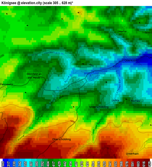
Below is the Elevation map of Königsee, which displays elevation range with different colors. Scale of the first map is from 305 to 628 m (1001 to 2060 ft) with average elevation of 454.7 meters (=1492 ft) [note 1]
These maps also provides idea of topography and contour of this city, they are displayed at different zoom levels. More info about maps, scale and edge coordinates you can find below images.
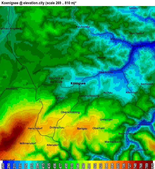
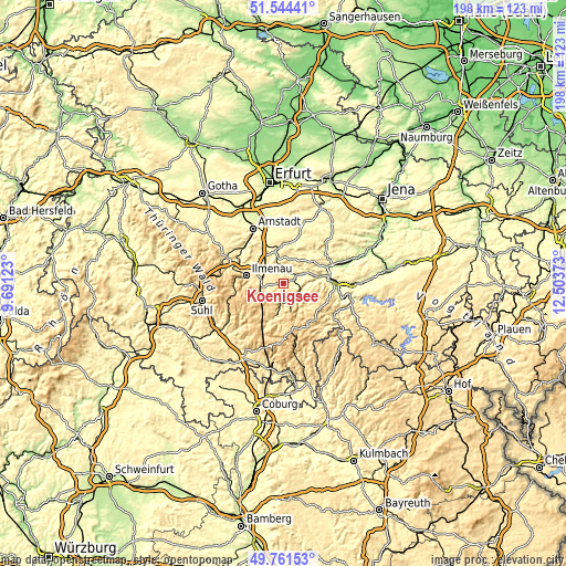
| \ | Map #1 | Map #2 | Topo.Map |
| Scale [m] | 305..628 m | 269..810 m | × |
| Scale [ft] | 1001..2060 ft | 883..2657 ft | × |
| Average | 454.7 m = 1492 ft | 469 m = 1539 ft | × |
| Width | 6.19 km = 3.8 mi | 12.39 km = 7.7 mi | 198.2 km = 123.2 mi |
| Height | 6.19 km = 3.8 mi | 12.39 km = 7.7 mi | 198.2 km = 123.2 mi |
| ↑Max Latitude | 50.689279° | 50.717111° | 51.54441° |
| Latitude at center | 50.66143° | 50.66143° | 50.66143° |
| ↓Min Latitude | 50.633565° | 50.605683° | 49.76153° |
| ← Min Longitude | 11.053535° | 11.009589° | 9.69123° |
| Longitude center | 11.09748° | 11.09748° | 11.09748° |
| →Max Longitude | 11.141425° | 11.185371° | 12.50373° |
Nearby cities:
Cities around Königsee sort by population:
• Ilmenau elevation 478 m
12.8 km,  280°
280°
• Bad Blankenburg 225 m
12.6 km,  79°
79°
• Neuhaus 480 m
11.8 km, 281°
• Langewiesen 445 m
9 km, 277°
• Gehren 480 m
6.7 km,  257°
257°
• Großbreitenbach 635 m
10.7 km,  215°
215°
• Katzhütte 430 m
12.6 km,  194°
194°
• Rottenbach 280 m
5.7 km,  58°
58°
• Oberweißbach 634 m
9.4 km,  159°
159°
• Meuselbach 583 m
10 km,  182°
182°
• Mellenbach-Glasbach 600 m
5 km, 177°
• Sitzendorf 307 m
6.2 km,  122°
122°
Multilingual:
 En español:
Königsee elevación 374 m.
 En France:
Königsee élévation 374 m.
 Auf Deutsch:
Königsee höhe über dem Meeresspiegel ist 374 m.

Sources and notes:
- [note 1] Map square and city borders are not equal. Map elevation data is calculated only from area inside that square.
- [src 1] Elevation data from geonames database provided with same terms of usage.
- [src 2] The elevation map of Königsee is generated using elevation data from NASA's 3 arcsec (90m) resolution SRTM data.
- [src 3] Base (background) map © OpenStreetMap contributors tiles are generated by Geofabrik and OpenTopoMap.
Copyright & License:
This Königsee Elevation Map is licensed under CC BY-SA. You may reuse any part from this page, if you give a proper credit by linking to this URL:
 More info on terms of use page.