Großbreitenbach elevation
Großbreitenbach (Thuringia), Germany elevation is 635 meters and Großbreitenbach elevation in feet is 2083 ft above sea level [src 1]. Großbreitenbach is a populated place (feature code) with elevation that is 377 meters (1237 ft) bigger than average city elevation in Germany.
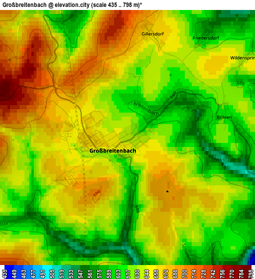
Below is the Elevation map of Großbreitenbach, which displays elevation range with different colors. Scale of the first map is from 435 to 798 m (1427 to 2618 ft) with average elevation of 639.4 meters (=2098 ft) [note 1]
These maps also provides idea of topography and contour of this city, they are displayed at different zoom levels. More info about maps, scale and edge coordinates you can find below images.
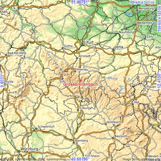
| \ | Map #1 | Topo.Map |
| Scale [m] | 435..798 m | × |
| Scale [ft] | 1427..2618 ft | × |
| Average | 639.4 m = 2098 ft | × |
| Width | 6.21 km = 3.9 mi | 198.6 km = 123.4 mi |
| Height | 6.21 km = 3.9 mi | 198.6 km = 123.4 mi |
| ↑Max Latitude | 50.611245° | 51.46781° |
| Latitude at center | 50.58335° | 50.58335° |
| ↓Min Latitude | 50.555438° | 49.68196° |
| ← Min Longitude | 10.965605° | 9.6033° |
| Longitude center | 11.00955° | 11.00955° |
| →Max Longitude | 11.053495° | 12.4158° |
Nearby cities:
Cities around Großbreitenbach sort by population:
• Königsee elevation 374 m
10.7 km,  35°
35°
• Langewiesen 445 m
10.3 km,  344°
344°
• Gehren 480 m
7.3 km,  357°
357°
• Masserberg 763 m
7.6 km,  201°
201°
• Katzhütte 430 m
4.6 km,  138°
138°
• Stützerbach 660 m
11.5 km,  298°
298°
• Oberweißbach 634 m
9.5 km,  90°
90°
• Meuselbach 583 m
5.9 km,  102°
102°
• Mellenbach-Glasbach 600 m
7.4 km,  59°
59°
• Frauenwald 752 m
10.7 km,  270°
270°
• Altenfeld 644 m
3.6 km,  238°
238°
• Neustadt am Rennsteig 787 m
5.4 km, 269°
Multilingual:
 En español:
Großbreitenbach elevación 635 m.
 En France:
Großbreitenbach élévation 635 m.
 Auf Deutsch:
Großbreitenbach höhe über dem Meeresspiegel ist 635 m.

Sources and notes:
- [note 1] Map square and city borders are not equal. Map elevation data is calculated only from area inside that square.
- [src 1] Elevation data from geonames database provided with same terms of usage.
- [src 2] The elevation map of Großbreitenbach is generated using elevation data from NASA's 3 arcsec (90m) resolution SRTM data.
- [src 3] Base (background) map © OpenStreetMap contributors tiles are generated by Geofabrik and OpenTopoMap.
Copyright & License:
This Großbreitenbach Elevation Map is licensed under CC BY-SA. You may reuse any part from this page, if you give a proper credit by linking to this URL:
 More info on terms of use page.