Neuhaus elevation
Neuhaus (Thuringia), Germany elevation is 480 meters and Neuhaus elevation in feet is 1575 ft above sea level [src 1]. Neuhaus is a populated place (feature code) with elevation that is 222 meters (728 ft) bigger than average city elevation in Germany.
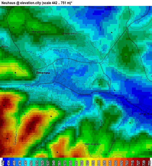
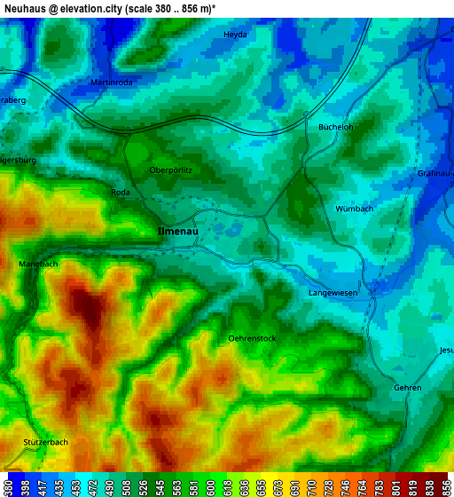
Below is the Elevation map of Neuhaus, which displays elevation range with different colors. Scale of the first map is from 442 to 751 m (1450 to 2464 ft) with average elevation of 533.7 meters (=1751 ft) [note 1]
These maps also provides idea of topography and contour of this city, they are displayed at different zoom levels. More info about maps, scale and edge coordinates you can find below images.
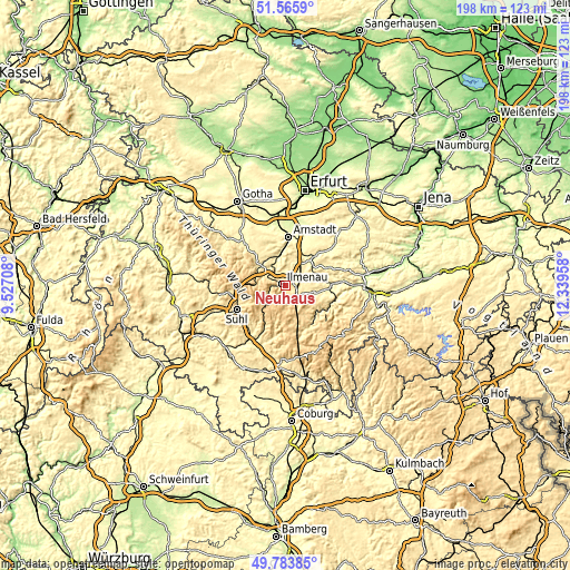
| \ | Map #1 | Map #2 | Topo.Map |
| Scale [m] | 442..751 m | 380..856 m | × |
| Scale [ft] | 1450..2464 ft | 1247..2808 ft | × |
| Average | 533.7 m = 1751 ft | 545 m = 1788 ft | × |
| Width | 6.19 km = 3.8 mi | 12.38 km = 7.7 mi | 198.1 km = 123.1 mi |
| Height | 6.19 km = 3.8 mi | 12.38 km = 7.7 mi | 198.1 km = 123.1 mi |
| ↑Max Latitude | 50.711166° | 50.738985° | 51.5659° |
| Latitude at center | 50.68333° | 50.68333° | 50.68333° |
| ↓Min Latitude | 50.655478° | 50.627609° | 49.78385° |
| ← Min Longitude | 10.889385° | 10.845439° | 9.52708° |
| Longitude center | 10.93333° | 10.93333° | 10.93333° |
| →Max Longitude | 10.977275° | 11.021221° | 12.33958° |
Nearby cities:
Cities around Neuhaus sort by population:
• Ilmenau elevation 478 m
1 km,  269°
269°
• Königsee 374 m
11.8 km,  101°
101°
• Langewiesen 445 m
2.9 km,  114°
114°
• Gehren 480 m
6.3 km,  127°
127°
• Gräfenroda 404 m
11.2 km,  309°
309°
• Behringen 366 m
11.5 km,  29°
29°
• Geraberg 437 m
7.7 km,  298°
298°
• Geschwenda 471 m
9.3 km, 305°
• Plaue 326 m
10.8 km,  347°
347°
• Stützerbach 660 m
7.3 km,  220°
220°
• Elgersburg 492 m
6.2 km,  294°
294°
• Neustadt am Rennsteig 787 m
11.1 km,  180°
180°
Multilingual:
 En español:
Neuhaus elevación 480 m.
 En France:
Neuhaus élévation 480 m.


Sources and notes:
- [note 1] Map square and city borders are not equal. Map elevation data is calculated only from area inside that square.
- [src 1] Elevation data from geonames database provided with same terms of usage.
- [src 2] The elevation map of Neuhaus is generated using elevation data from NASA's 3 arcsec (90m) resolution SRTM data.
- [src 3] Base (background) map © OpenStreetMap contributors tiles are generated by Geofabrik and OpenTopoMap.
Copyright & License:
This Neuhaus Elevation Map is licensed under CC BY-SA. You may reuse any part from this page, if you give a proper credit by linking to this URL:
 More info on terms of use page.