Lampertheim elevation
Lampertheim (Hesse, Regierungsbezirk Darmstadt), Germany elevation is 97 meters and Lampertheim elevation in feet is 318 ft above sea level [src 1]. Lampertheim is a populated place (feature code) with elevation that is 161 meters (528 ft) smaller than average city elevation in Germany.
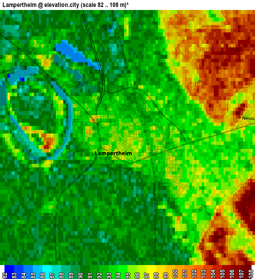
Below is the Elevation map of Lampertheim, which displays elevation range with different colors. Scale of the first map is from 82 to 108 m (269 to 354 ft) with average elevation of 93.4 meters (=306 ft) [note 1]
These maps also provides idea of topography and contour of this city, they are displayed at different zoom levels. More info about maps, scale and edge coordinates you can find below images.

| \ | Map #1 | Map #2 | Topo.Map |
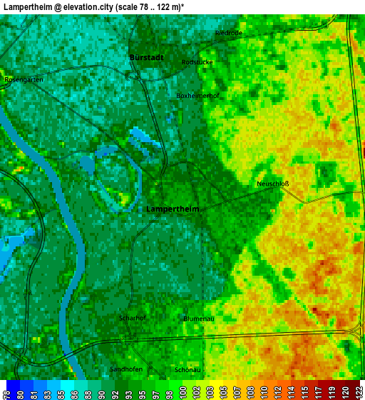
| Scale [m] | 82..108 m | 78..122 m | × |
| Scale [ft] | 269..354 ft | 256..400 ft | × |
| Average | 93.4 m = 306 ft | 95.8 m = 314 ft | × |
| Width | 6.33 km = 3.9 mi | 12.67 km = 7.9 mi | 202.7 km = 126 mi |
| Height | 6.33 km = 3.9 mi | 12.67 km = 7.9 mi | 202.7 km = 126 mi |
| ↑Max Latitude | 49.626335° | 49.654793° | 50.50082° |
| Latitude at center | 49.59786° | 49.59786° | 49.59786° |
| ↓Min Latitude | 49.569369° | 49.540861° | 48.67787° |
| ← Min Longitude | 8.428555° | 8.384609° | 7.06625° |
| Longitude center | 8.4725° | 8.4725° | 8.4725° |
| →Max Longitude | 8.516445° | 8.560391° | 9.87875° |
Nearby cities:
Cities around Lampertheim sort by population:
• Mannheim elevation 100 m
12.1 km,  181°
181°
• Worms 104 m
9 km,  295°
295°
• Frankenthal 99 m
11.1 km,  230°
230°
• Viernheim 103 m
10 km,  130°
130°
• Heppenheim an der Bergstrasse 103 m
12.5 km,  67°
67°
• Bürstadt 95 m
5.1 km,  349°
349°
• Lorsch 99 m
8.9 km,  49°
49°
• Bobenheim-Roxheim 95 m
8.3 km,  262°
262°
• Biblis 91 m
10.5 km, 354°
• Einhausen 93 m
10.3 km,  31°
31°
• Beindersheim 95 m
11.8 km,  249°
249°
• Großniedesheim 99 m
11.8 km, 257°
Multilingual:
 En español:
Lampertheim elevación 97 m.
 En France:
Lampertheim élévation 97 m.
 Auf Deutsch:
Lampertheim höhe über dem Meeresspiegel ist 97 m.

Sources and notes:
- [note 1] Map square and city borders are not equal. Map elevation data is calculated only from area inside that square.
- [src 1] Elevation data from geonames database provided with same terms of usage.
- [src 2] The elevation map of Lampertheim is generated using elevation data from NASA's 3 arcsec (90m) resolution SRTM data.
- [src 3] Base (background) map © OpenStreetMap contributors tiles are generated by Geofabrik and OpenTopoMap.
Copyright & License:
This Lampertheim Elevation Map is licensed under CC BY-SA. You may reuse any part from this page, if you give a proper credit by linking to this URL:
 More info on terms of use page.