Langgöns elevation
Langgöns (Hesse, Regierungsbezirk Gießen), Germany elevation is 207 meters and Langgöns elevation in feet is 679 ft above sea level [src 1]. Langgöns is a seat of a fourth-order administrative division (feature code) with elevation that is 51 meters (167 ft) smaller than average city elevation in Germany.
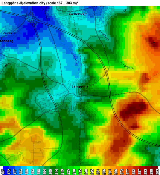
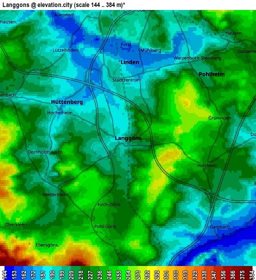
Below is the Elevation map of Langgöns, which displays elevation range with different colors. Scale of the first map is from 167 to 303 m (548 to 994 ft) with average elevation of 223.4 meters (=733 ft) [note 1]
These maps also provides idea of topography and contour of this city, they are displayed at different zoom levels. More info about maps, scale and edge coordinates you can find below images.
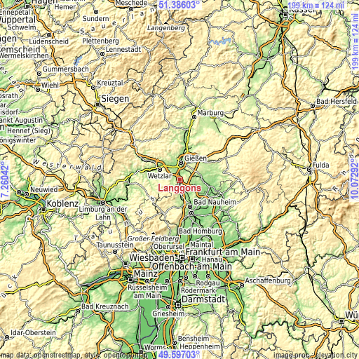
| \ | Map #1 | Map #2 | Topo.Map |
| Scale [m] | 167..303 m | 144..384 m | × |
| Scale [ft] | 548..994 ft | 472..1260 ft | × |
| Average | 223.4 m = 733 ft | 218.7 m = 718 ft | × |
| Width | 6.22 km = 3.9 mi | 12.43 km = 7.7 mi | 198.9 km = 123.6 mi |
| Height | 6.22 km = 3.9 mi | 12.43 km = 7.7 mi | 198.9 km = 123.6 mi |
| ↑Max Latitude | 50.527944° | 50.555872° | 51.38603° |
| Latitude at center | 50.5° | 50.5° | 50.5° |
| ↓Min Latitude | 50.472039° | 50.444062° | 49.59703° |
| ← Min Longitude | 8.622725° | 8.578779° | 7.26042° |
| Longitude center | 8.66667° | 8.66667° | 8.66667° |
| →Max Longitude | 8.710615° | 8.754561° | 10.07292° |
Nearby cities:
Cities around Langgöns sort by population:
• Gießen elevation 162 m
9.7 km,  3°
3°
• Wetzlar 169 m
13.3 km,  300°
300°
• Butzbach 206 m
7.4 km,  177°
177°
• Lich 181 m
10.8 km,  77°
77°
• Heuchelheim 161 m
9.6 km,  345°
345°
• Schöffengrund 283 m
13.8 km,  266°
266°
• Münzenberg 189 m
9.2 km,  124°
124°
• Allendorf an der Lahn 159 m
6.6 km,  329°
329°
• Rockenberg 164 m
9.2 km,  147°
147°
• Hörnsheim 176 m
3.3 km,  307°
307°
• Schwalbach 274 m
14 km, 268°
• Wohnbach 159 m
14 km, 124°
Multilingual:
 En español:
Langgöns elevación 207 m.
 En France:
Langgöns élévation 207 m.
 Auf Deutsch:
Langgöns höhe über dem Meeresspiegel ist 207 m.

Sources and notes:
- [note 1] Map square and city borders are not equal. Map elevation data is calculated only from area inside that square.
- [src 1] Elevation data from geonames database provided with same terms of usage.
- [src 2] The elevation map of Langgöns is generated using elevation data from NASA's 3 arcsec (90m) resolution SRTM data.
- [src 3] Base (background) map © OpenStreetMap contributors tiles are generated by Geofabrik and OpenTopoMap.
Copyright & License:
This Langgöns Elevation Map is licensed under CC BY-SA. You may reuse any part from this page, if you give a proper credit by linking to this URL:
 More info on terms of use page.