Lich elevation
Lich (Hesse, Regierungsbezirk Gießen), Germany elevation is 181 meters and Lich elevation in feet is 594 ft above sea level [src 1]. Lich is a populated place (feature code) with elevation that is 77 meters (253 ft) smaller than average city elevation in Germany.
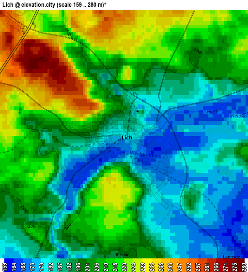
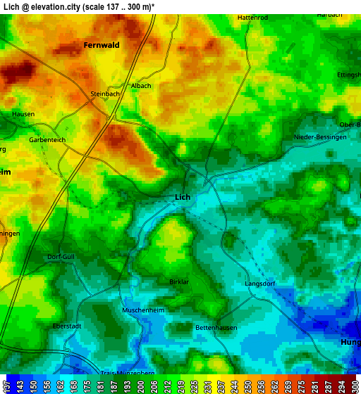
Below is the Elevation map of Lich, which displays elevation range with different colors. Scale of the first map is from 159 to 280 m (522 to 919 ft) with average elevation of 202.2 meters (=663 ft) [note 1]
These maps also provides idea of topography and contour of this city, they are displayed at different zoom levels. More info about maps, scale and edge coordinates you can find below images.
| \ | Map #1 | Map #2 | Topo.Map |
| Scale [m] | 159..280 m | 137..300 m | × |
| Scale [ft] | 522..919 ft | 449..984 ft | × |
| Average | 202.2 m = 663 ft | 204.7 m = 672 ft | × |
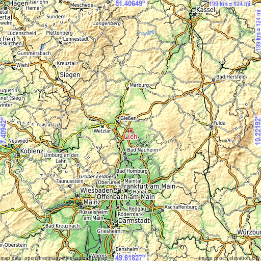
| Width | 6.21 km = 3.9 mi | 12.43 km = 7.7 mi | 198.8 km = 123.5 mi |
| Height | 6.21 km = 3.9 mi | 12.43 km = 7.7 mi | 198.8 km = 123.5 mi |
| ↑Max Latitude | 50.548782° | 50.576698° | 51.40649° |
| Latitude at center | 50.52085° | 50.52085° | 50.52085° |
| ↓Min Latitude | 50.492901° | 50.464936° | 49.61827° |
| ← Min Longitude | 8.771725° | 8.727779° | 7.40942° |
| Longitude center | 8.81567° | 8.81567° | 8.81567° |
| →Max Longitude | 8.859615° | 8.903561° | 10.22192° |
Nearby cities:
Cities around Lich sort by population:
• Gießen elevation 162 m
12.4 km,  306°
306°
• Grünberg 269 m
13 km,  51°
51°
• Langgöns 207 m
10.8 km,  257°
257°
• Reiskirchen 228 m
8.9 km,  8°
8°
• Laubach 209 m
12.6 km,  79°
79°
• Münzenberg 189 m
8 km,  201°
201°
• Hungen 162 m
7.6 km,  133°
133°
• Alten Buseck 229 m
12.1 km,  338°
338°
• Rockenberg 164 m
11.5 km,  209°
209°
• Beuern 234 m
11.9 km,  1°
1°
• Berstadt 145 m
11.1 km,  161°
161°
• Wohnbach 159 m
10.3 km,  174°
174°
Multilingual:
 En español:
Lich elevación 181 m.
 En France:
Lich élévation 181 m.


Sources and notes:
- [note 1] Map square and city borders are not equal. Map elevation data is calculated only from area inside that square.
- [src 1] Elevation data from geonames database provided with same terms of usage.
- [src 2] The elevation map of Lich is generated using elevation data from NASA's 3 arcsec (90m) resolution SRTM data.
- [src 3] Base (background) map © OpenStreetMap contributors tiles are generated by Geofabrik and OpenTopoMap.
Copyright & License:
This Lich Elevation Map is licensed under CC BY-SA. You may reuse any part from this page, if you give a proper credit by linking to this URL:
 More info on terms of use page.