Lauenau elevation
Lauenau (Lower Saxony), Germany elevation is 87 meters and Lauenau elevation in feet is 285 ft above sea level [src 1]. Lauenau is a populated place (feature code) with elevation that is 171 meters (561 ft) smaller than average city elevation in Germany.
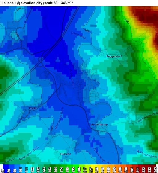
Below is the Elevation map of Lauenau, which displays elevation range with different colors. Scale of the first map is from 69 to 343 m (226 to 1125 ft) with average elevation of 120 meters (=394 ft) [note 1]
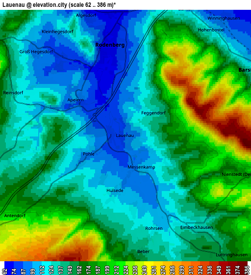
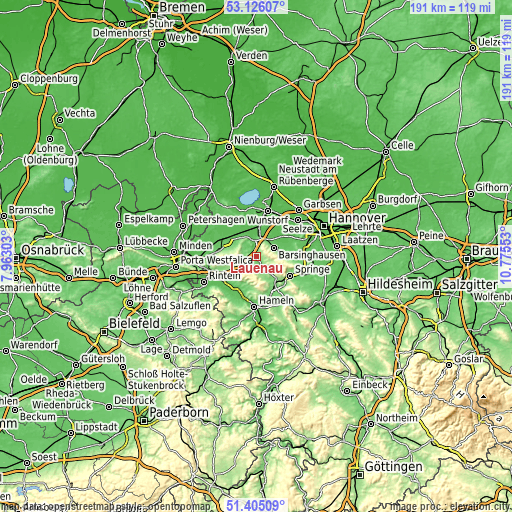
These maps also provides idea of topography and contour of this city, they are displayed at different zoom levels. More info about maps, scale and edge coordinates you can find below images.
| \ | Map #1 | Map #2 | Topo.Map |
| Scale [m] | 69..343 m | 62..386 m | × |
| Scale [ft] | 226..1125 ft | 203..1266 ft | × |
| Average | 120 m = 394 ft | 156 m = 512 ft | × |
| Width | 5.98 km = 3.7 mi | 11.96 km = 7.4 mi | 191.4 km = 118.9 mi |
| Height | 5.98 km = 3.7 mi | 11.96 km = 7.4 mi | 191.3 km = 118.9 mi |
| ↑Max Latitude | 52.300811° | 52.327677° | 53.12607° |
| Latitude at center | 52.27393° | 52.27393° | 52.27393° |
| ↓Min Latitude | 52.247032° | 52.220118° | 51.40509° |
| ← Min Longitude | 9.325335° | 9.281389° | 7.96303° |
| Longitude center | 9.36928° | 9.36928° | 9.36928° |
| →Max Longitude | 9.413225° | 9.457171° | 10.77553° |
Nearby cities:
Cities around Lauenau sort by population:
• Bad Münder am Deister elevation 118 m
10.9 km,  143°
143°
• Barsinghausen 182 m
6.2 km,  62°
62°
• Bad Nenndorf 86 m
7 km,  5°
5°
• Egestorf 88 m
10.1 km,  82°
82°
• Rodenberg 71 m
4.3 km,  348°
348°
• Lindhorst 58 m
11 km,  327°
327°
• Apelern 95 m
2.9 km,  307°
307°
• Hohnhorst 62 m
10.6 km,  0°
0°
• Beckedorf 59 m
9.2 km,  337°
337°
• Großgoltern 60 m
11.1 km,  53°
53°
• Hülsede 109 m
2.8 km,  191°
191°
• Heuerßen 98 m
8.8 km, 314°
Multilingual:
 En español:
Lauenau elevación 87 m.
 En France:
Lauenau élévation 87 m.


Sources and notes:
- [note 1] Map square and city borders are not equal. Map elevation data is calculated only from area inside that square.
- [src 1] Elevation data from geonames database provided with same terms of usage.
- [src 2] The elevation map of Lauenau is generated using elevation data from NASA's 3 arcsec (90m) resolution SRTM data.
- [src 3] Base (background) map © OpenStreetMap contributors tiles are generated by Geofabrik and OpenTopoMap.
Copyright & License:
This Lauenau Elevation Map is licensed under CC BY-SA. You may reuse any part from this page, if you give a proper credit by linking to this URL:
 More info on terms of use page.