Egestorf elevation
Egestorf (Lower Saxony), Germany elevation is 88 meters and Egestorf elevation in feet is 289 ft above sea level [src 1]. Egestorf is a populated place (feature code) with elevation that is 170 meters (558 ft) smaller than average city elevation in Germany.
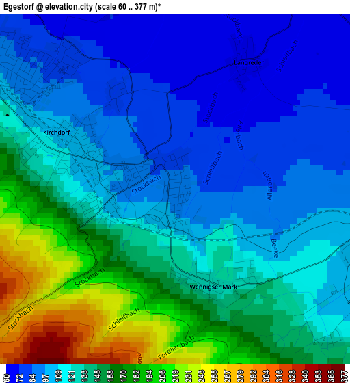
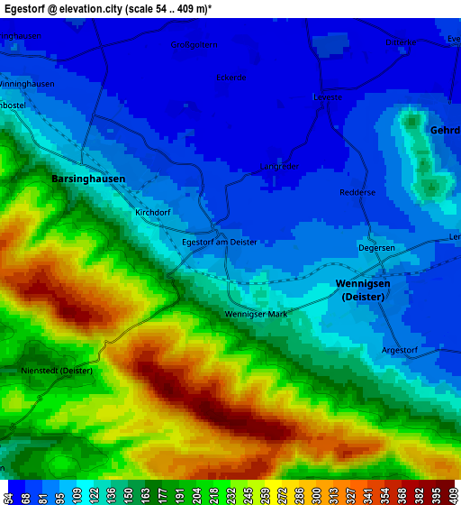
Below is the Elevation map of Egestorf, which displays elevation range with different colors. Scale of the first map is from 60 to 377 m (197 to 1237 ft) with average elevation of 127.8 meters (=419 ft) [note 1]
These maps also provides idea of topography and contour of this city, they are displayed at different zoom levels. More info about maps, scale and edge coordinates you can find below images.
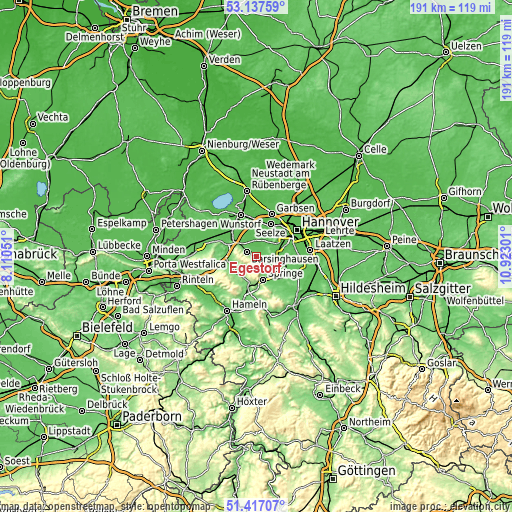
| \ | Map #1 | Map #2 | Topo.Map |
| Scale [m] | 60..377 m | 54..409 m | × |
| Scale [ft] | 197..1237 ft | 177..1342 ft | × |
| Average | 127.8 m = 419 ft | 151.3 m = 496 ft | × |
| Width | 5.98 km = 3.7 mi | 11.96 km = 7.4 mi | 191.3 km = 118.9 mi |
| Height | 5.98 km = 3.7 mi | 11.96 km = 7.4 mi | 191.3 km = 118.9 mi |
| ↑Max Latitude | 52.312554° | 52.339412° | 53.13759° |
| Latitude at center | 52.28568° | 52.28568° | 52.28568° |
| ↓Min Latitude | 52.258789° | 52.231883° | 51.41707° |
| ← Min Longitude | 9.472815° | 9.428869° | 8.11051° |
| Longitude center | 9.51676° | 9.51676° | 9.51676° |
| →Max Longitude | 9.560705° | 9.604651° | 10.92301° |
Nearby cities:
Cities around Egestorf sort by population:
• Springe elevation 110 m
9 km,  163°
163°
• Ronnenberg 69 m
10.1 km,  68°
68°
• Bad Münder am Deister 118 m
10.6 km,  199°
199°
• Gehrden 78 m
6.5 km,  61°
61°
• Barsinghausen 182 m
4.8 km,  289°
289°
• Wennigsen 91 m
4 km,  108°
108°
• Bad Nenndorf 86 m
11 km,  301°
301°
• Rodenberg 71 m
11.3 km,  284°
284°
• Lauenau 87 m
10.1 km,  262°
262°
• Großgoltern 60 m
5.3 km,  348°
348°
• Groß Munzel 59 m
9.3 km,  343°
343°
• Hülsede 109 m
11.3 km,  249°
249°
Multilingual:
 En español:
Egestorf elevación 88 m.
 En France:
Egestorf élévation 88 m.
 Auf Deutsch:
Egestorf (Deister) höhe über dem Meeresspiegel ist 88 m.

Sources and notes:
- [note 1] Map square and city borders are not equal. Map elevation data is calculated only from area inside that square.
- [src 1] Elevation data from geonames database provided with same terms of usage.
- [src 2] The elevation map of Egestorf is generated using elevation data from NASA's 3 arcsec (90m) resolution SRTM data.
- [src 3] Base (background) map © OpenStreetMap contributors tiles are generated by Geofabrik and OpenTopoMap.
Copyright & License:
This Egestorf Elevation Map is licensed under CC BY-SA. You may reuse any part from this page, if you give a proper credit by linking to this URL:
 More info on terms of use page.