Lindhorst elevation
Lindhorst (Lower Saxony), Germany elevation is 58 meters and Lindhorst elevation in feet is 190 ft above sea level [src 1]. Lindhorst is a seat of a fourth-order administrative division (feature code) with elevation that is 200 meters (656 ft) smaller than average city elevation in Germany.
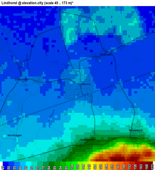
Below is the Elevation map of Lindhorst, which displays elevation range with different colors. Scale of the first map is from 45 to 173 m (148 to 568 ft) with average elevation of 62.5 meters (=205 ft) [note 1]
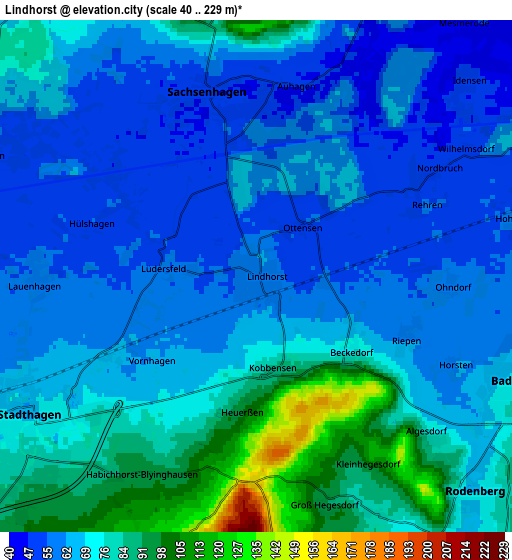
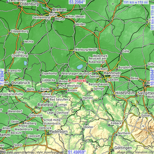
These maps also provides idea of topography and contour of this city, they are displayed at different zoom levels. More info about maps, scale and edge coordinates you can find below images.
| \ | Map #1 | Map #2 | Topo.Map |
| Scale [m] | 45..173 m | 40..229 m | × |
| Scale [ft] | 148..568 ft | 131..751 ft | × |
| Average | 62.5 m = 205 ft | 69.1 m = 227 ft | × |
| Width | 5.97 km = 3.7 mi | 11.94 km = 7.4 mi | 191 km = 118.7 mi |
| Height | 5.97 km = 3.7 mi | 11.94 km = 7.4 mi | 191 km = 118.7 mi |
| ↑Max Latitude | 52.38472° | 52.411535° | 53.2084° |
| Latitude at center | 52.35789° | 52.35789° | 52.35789° |
| ↓Min Latitude | 52.331043° | 52.30418° | 51.49069° |
| ← Min Longitude | 9.239245° | 9.195299° | 7.87694° |
| Longitude center | 9.28319° | 9.28319° | 9.28319° |
| →Max Longitude | 9.327135° | 9.371081° | 10.68944° |
Nearby cities:
Cities around Lindhorst sort by population:
• Stadthagen elevation 77 m
6.7 km,  234°
234°
• Bad Nenndorf 86 m
6.9 km,  109°
109°
• Rodenberg 71 m
7.2 km,  136°
136°
• Hohnhorst 62 m
6.1 km,  77°
77°
• Sachsenhagen 49 m
4.5 km,  346°
346°
• Wölpinghausen 86 m
7.4 km,  332°
332°
• Beckedorf 59 m
2.4 km, 111°
• Lauenhagen 58 m
5.2 km,  267°
267°
• Auhagen 52 m
4.5 km,  7°
7°
• Pollhagen 52 m
7.1 km,  295°
295°
• Lüdersfeld 55 m
2 km,  276°
276°
• Heuerßen 98 m
3.2 km,  187°
187°
Multilingual:
 En español:
Lindhorst elevación 58 m.
 En France:
Lindhorst élévation 58 m.
 Auf Deutsch:
Lindhorst höhe über dem Meeresspiegel ist 58 m.

Sources and notes:
- [note 1] Map square and city borders are not equal. Map elevation data is calculated only from area inside that square.
- [src 1] Elevation data from geonames database provided with same terms of usage.
- [src 2] The elevation map of Lindhorst is generated using elevation data from NASA's 3 arcsec (90m) resolution SRTM data.
- [src 3] Base (background) map © OpenStreetMap contributors tiles are generated by Geofabrik and OpenTopoMap.
Copyright & License:
This Lindhorst Elevation Map is licensed under CC BY-SA. You may reuse any part from this page, if you give a proper credit by linking to this URL:
 More info on terms of use page.