Wölpinghausen elevation
Wölpinghausen (Lower Saxony), Germany elevation is 86 meters and Wölpinghausen elevation in feet is 282 ft above sea level [src 1]. Wölpinghausen is a seat of a fourth-order administrative division (feature code) with elevation that is 172 meters (564 ft) smaller than average city elevation in Germany.
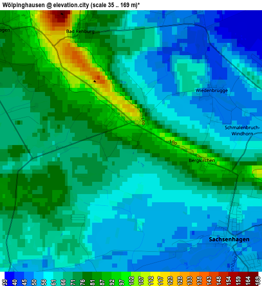
Below is the Elevation map of Wölpinghausen, which displays elevation range with different colors. Scale of the first map is from 35 to 169 m (115 to 554 ft) with average elevation of 67.5 meters (=221 ft) [note 1]
These maps also provides idea of topography and contour of this city, they are displayed at different zoom levels. More info about maps, scale and edge coordinates you can find below images.
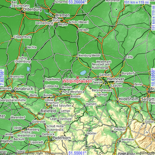
| \ | Map #1 | Topo.Map |
| Scale [m] | 35..169 m | × |
| Scale [ft] | 115..554 ft | × |
| Average | 67.5 m = 221 ft | × |
| Width | 5.96 km = 3.7 mi | 190.7 km = 118.5 mi |
| Height | 5.96 km = 3.7 mi | 190.7 km = 118.5 mi |
| ↑Max Latitude | 52.443465° | 53.26604° |
| Latitude at center | 52.41667° | 52.41667° |
| ↓Min Latitude | 52.389859° | 51.55061° |
| ← Min Longitude | 9.189385° | 7.82708° |
| Longitude center | 9.23333° | 9.23333° |
| →Max Longitude | 9.277275° | 10.63958° |
Nearby cities:
Cities around Wölpinghausen sort by population:
• Rehburg-Loccum elevation 38 m
6.3 km,  338°
338°
• Lindhorst 58 m
7.4 km,  152°
152°
• Hagenburg 42 m
6.5 km,  73°
73°
• Sachsenhagen 49 m
3.2 km,  132°
132°
• Meerbeck 64 m
10 km,  213°
213°
• Niedernwöhren 62 m
9.2 km,  218°
218°
• Beckedorf 59 m
9.3 km,  142°
142°
• Lauenhagen 58 m
7 km,  195°
195°
• Auhagen 52 m
4.5 km,  117°
117°
• Pollhagen 52 m
4.6 km, 221°
• Lüdersfeld 55 m
6.5 km,  167°
167°
• Wiedensahl 67 m
8.5 km,  244°
244°
Multilingual:
 En español:
Wölpinghausen elevación 86 m.
 En France:
Wölpinghausen élévation 86 m.
 Auf Deutsch:
Wölpinghausen höhe über dem Meeresspiegel ist 86 m.

Sources and notes:
- [note 1] Map square and city borders are not equal. Map elevation data is calculated only from area inside that square.
- [src 1] Elevation data from geonames database provided with same terms of usage.
- [src 2] The elevation map of Wölpinghausen is generated using elevation data from NASA's 3 arcsec (90m) resolution SRTM data.
- [src 3] Base (background) map © OpenStreetMap contributors tiles are generated by Geofabrik and OpenTopoMap.
Copyright & License:
This Wölpinghausen Elevation Map is licensed under CC BY-SA. You may reuse any part from this page, if you give a proper credit by linking to this URL:
 More info on terms of use page.