Laufenburg elevation
Laufenburg (Baden-Württemberg, Freiburg Region), Germany elevation is 341 meters and Laufenburg elevation in feet is 1119 ft above sea level [src 1]. Laufenburg is a populated place (feature code) with elevation that is 83 meters (272 ft) bigger than average city elevation in Germany.
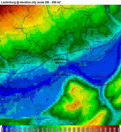
Below is the Elevation map of Laufenburg, which displays elevation range with different colors. Scale of the first map is from 290 to 650 m (951 to 2133 ft) with average elevation of 400.6 meters (=1314 ft) [note 1]
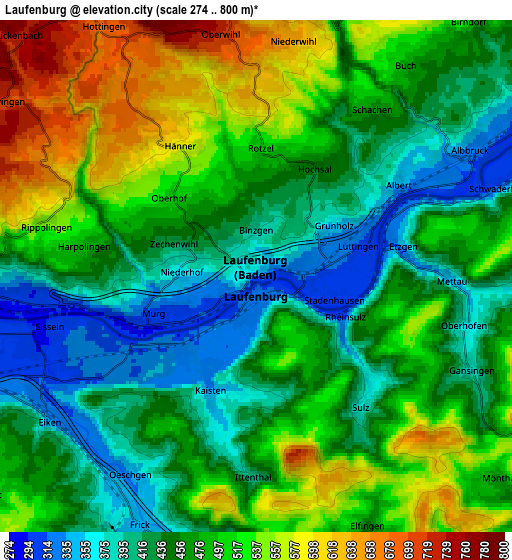
These maps also provides idea of topography and contour of this city, they are displayed at different zoom levels. More info about maps, scale and edge coordinates you can find below images.
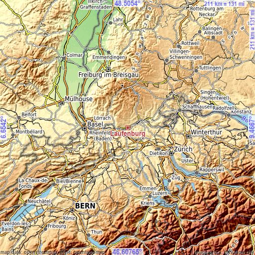
| \ | Map #1 | Map #2 | Topo.Map |
| Scale [m] | 290..650 m | 274..800 m | × |
| Scale [ft] | 951..2133 ft | 899..2625 ft | × |
| Average | 400.6 m = 1314 ft | 473.7 m = 1554 ft | × |
| Width | 6.59 km = 4.1 mi | 13.19 km = 8.2 mi | 211 km = 131.1 mi |
| Height | 6.59 km = 4.1 mi | 13.19 km = 8.2 mi | 211 km = 131.1 mi |
| ↑Max Latitude | 47.594764° | 47.624391° | 48.5054° |
| Latitude at center | 47.56512° | 47.56512° | 47.56512° |
| ↓Min Latitude | 47.535459° | 47.505782° | 46.60765° |
| ← Min Longitude | 8.016505° | 7.972559° | 6.6542° |
| Longitude center | 8.06045° | 8.06045° | 8.06045° |
| →Max Longitude | 8.104395° | 8.148341° | 9.4667° |
Nearby cities:
Cities around Laufenburg sort by population:
• Waldshut-Tiengen elevation 341 m
13.4 km,  61°
61°
• Bad Säckingen 290 m
8.7 km,  261°
261°
• Wehr 358 m
13.7 km,  301°
301°
• Albbruck 315 m
5.9 km, 61°
• Murg 308 m
3.1 km,  248°
248°
• Görwihl 685 m
8.7 km,  7°
7°
• Rickenbach 725 m
8.6 km,  314°
314°
• Weilheim 669 m
17.2 km,  48°
48°
• Herrischried 882 m
12.2 km,  338°
338°
• Schwörstadt 292 m
14 km,  282°
282°
• Dogern 326 m
9.4 km, 58°
• Hasel 401 m
15.7 km, 308°
Multilingual:
 En español:
Laufenburg elevación 341 m.
 En France:
Laufenburg élévation 341 m.
 Auf Deutsch:
Laufenburg höhe über dem Meeresspiegel ist 341 m.

Sources and notes:
- [note 1] Map square and city borders are not equal. Map elevation data is calculated only from area inside that square.
- [src 1] Elevation data from geonames database provided with same terms of usage.
- [src 2] The elevation map of Laufenburg is generated using elevation data from NASA's 3 arcsec (90m) resolution SRTM data.
- [src 3] Base (background) map © OpenStreetMap contributors tiles are generated by Geofabrik and OpenTopoMap.
Copyright & License:
This Laufenburg Elevation Map is licensed under CC BY-SA. You may reuse any part from this page, if you give a proper credit by linking to this URL:
 More info on terms of use page.