Wehr elevation
Wehr (Baden-Württemberg, Freiburg Region), Germany elevation is 358 meters and Wehr elevation in feet is 1175 ft above sea level [src 1]. Wehr is a populated place (feature code) with elevation that is 100 meters (328 ft) bigger than average city elevation in Germany.
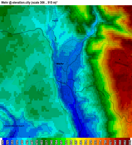
Below is the Elevation map of Wehr, which displays elevation range with different colors. Scale of the first map is from 306 to 915 m (1004 to 3002 ft) with average elevation of 503.6 meters (=1652 ft) [note 1]
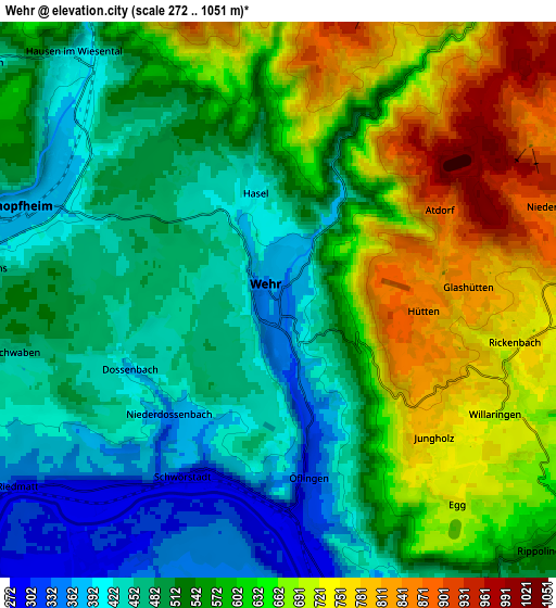
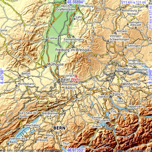
These maps also provides idea of topography and contour of this city, they are displayed at different zoom levels. More info about maps, scale and edge coordinates you can find below images.
| \ | Map #1 | Map #2 | Topo.Map |
| Scale [m] | 306..915 m | 272..1051 m | × |
| Scale [ft] | 1004..3002 ft | 892..3448 ft | × |
| Average | 503.6 m = 1652 ft | 565.8 m = 1856 ft | × |
| Width | 6.59 km = 4.1 mi | 13.17 km = 8.2 mi | 210.7 km = 130.9 mi |
| Height | 6.59 km = 4.1 mi | 13.17 km = 8.2 mi | 210.7 km = 130.9 mi |
| ↑Max Latitude | 47.659437° | 47.689027° | 48.56894° |
| Latitude at center | 47.62983° | 47.62983° | 47.62983° |
| ↓Min Latitude | 47.600206° | 47.570565° | 46.67353° |
| ← Min Longitude | 7.860285° | 7.816339° | 6.49798° |
| Longitude center | 7.90423° | 7.90423° | 7.90423° |
| →Max Longitude | 7.948175° | 7.992121° | 9.31048° |
Nearby cities:
Cities around Wehr sort by population:
• Rheinfelden elevation 279 m
11.7 km,  228°
228°
• Schopfheim 376 m
6.7 km,  290°
290°
• Bad Säckingen 290 m
9 km,  159°
159°
• Steinen 330 m
12.5 km,  277°
277°
• Murg 308 m
12.1 km,  133°
133°
• Zell im Wiesental 431 m
9.3 km,  335°
335°
• Maulburg 350 m
9.3 km, 281°
• Rickenbach 725 m
5.7 km,  102°
102°
• Herrischried 882 m
8.3 km,  60°
60°
• Schwörstadt 292 m
4.5 km,  205°
205°
• Hausen 406 m
7.5 km,  319°
319°
• Hasel 401 m
2.7 km,  348°
348°
Multilingual:
 En español:
Wehr elevación 358 m.
 En France:
Wehr élévation 358 m.


Sources and notes:
- [note 1] Map square and city borders are not equal. Map elevation data is calculated only from area inside that square.
- [src 1] Elevation data from geonames database provided with same terms of usage.
- [src 2] The elevation map of Wehr is generated using elevation data from NASA's 3 arcsec (90m) resolution SRTM data.
- [src 3] Base (background) map © OpenStreetMap contributors tiles are generated by Geofabrik and OpenTopoMap.
Copyright & License:
This Wehr Elevation Map is licensed under CC BY-SA. You may reuse any part from this page, if you give a proper credit by linking to this URL:
 More info on terms of use page.