Zell im Wiesental elevation
Zell im Wiesental (Baden-Württemberg, Freiburg Region), Germany elevation is 431 meters and Zell im Wiesental elevation in feet is 1414 ft above sea level [src 1]. Zell im Wiesental is a populated place (feature code) with elevation that is 173 meters (568 ft) bigger than average city elevation in Germany.
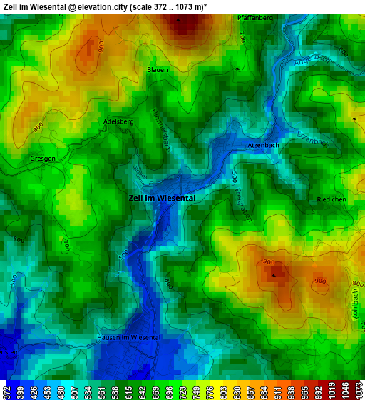
Below is the Elevation map of Zell im Wiesental, which displays elevation range with different colors. Scale of the first map is from 372 to 1073 m (1220 to 3520 ft) with average elevation of 643.7 meters (=2112 ft) [note 1]
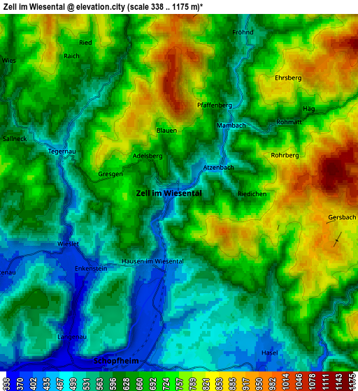
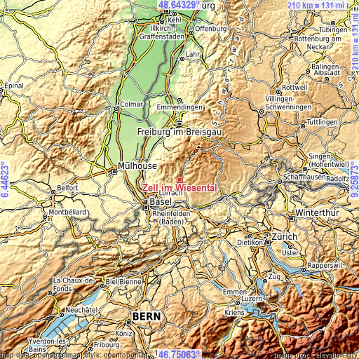
These maps also provides idea of topography and contour of this city, they are displayed at different zoom levels. More info about maps, scale and edge coordinates you can find below images.
| \ | Map #1 | Map #2 | Topo.Map |
| Scale [m] | 372..1073 m | 338..1175 m | × |
| Scale [ft] | 1220..3520 ft | 1109..3855 ft | × |
| Average | 643.7 m = 2112 ft | 652.5 m = 2141 ft | × |
| Width | 6.58 km = 4.1 mi | 13.15 km = 8.2 mi | 210.4 km = 130.7 mi |
| Height | 6.58 km = 4.1 mi | 13.15 km = 8.2 mi | 210.4 km = 130.7 mi |
| ↑Max Latitude | 47.735114° | 47.764662° | 48.64329° |
| Latitude at center | 47.70555° | 47.70555° | 47.70555° |
| ↓Min Latitude | 47.675969° | 47.646371° | 46.75063° |
| ← Min Longitude | 7.808535° | 7.764589° | 6.44623° |
| Longitude center | 7.85248° | 7.85248° | 7.85248° |
| →Max Longitude | 7.896425° | 7.940371° | 9.25873° |
Nearby cities:
Cities around Zell im Wiesental sort by population:
• Schopfheim elevation 376 m
6.5 km,  201°
201°
• Wehr 358 m
9.3 km,  155°
155°
• Steinen 330 m
10.9 km,  231°
231°
• Kandern 348 m
14.3 km,  273°
273°
• Maulburg 350 m
8.4 km,  218°
218°
• Rickenbach 725 m
13.5 km,  135°
135°
• Herrischried 882 m
11.9 km,  111°
111°
• Schönau im Schwarzwald 535 m
9.5 km,  19°
19°
• Schwörstadt 292 m
12.6 km,  171°
171°
• Hausen 406 m
2.9 km, 199°
• Todtmoos 809 m
11.8 km,  71°
71°
• Hasel 401 m
6.7 km,  149°
149°
Multilingual:
 En español:
Zell en el Valle del Wiese elevación 431 m.
 En France:
Zell im Wiesental élévation 431 m.
 Auf Deutsch:
Zell im Wiesental höhe über dem Meeresspiegel ist 431 m.
 На русском:
Целль-им-Визенталь высота над уровнем моря 431 м
Sources and notes:
- [note 1] Map square and city borders are not equal. Map elevation data is calculated only from area inside that square.
- [src 1] Elevation data from geonames database provided with same terms of usage.
- [src 2] The elevation map of Zell im Wiesental is generated using elevation data from NASA's 3 arcsec (90m) resolution SRTM data.
- [src 3] Base (background) map © OpenStreetMap contributors tiles are generated by Geofabrik and OpenTopoMap.
Copyright & License:
This Zell im Wiesental Elevation Map is licensed under CC BY-SA. You may reuse any part from this page, if you give a proper credit by linking to this URL:
 More info on terms of use page.