Lehre elevation
Lehre (Lower Saxony), Germany elevation is 76 meters and Lehre elevation in feet is 249 ft above sea level [src 1]. Lehre is a seat of a fourth-order administrative division (feature code) with elevation that is 182 meters (597 ft) smaller than average city elevation in Germany.
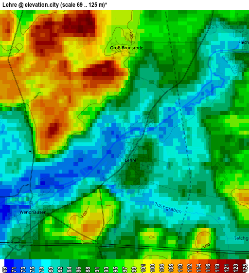
Below is the Elevation map of Lehre, which displays elevation range with different colors. Scale of the first map is from 69 to 125 m (226 to 410 ft) with average elevation of 90.4 meters (=297 ft) [note 1]
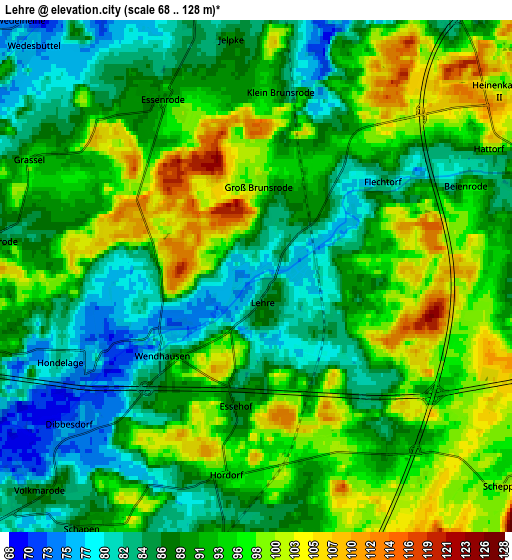
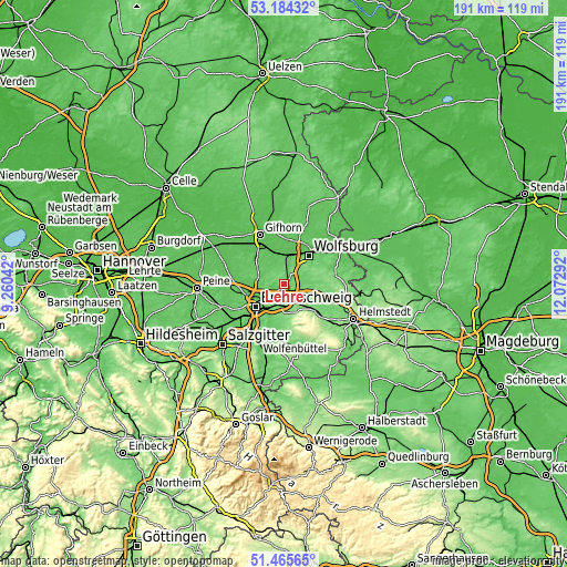
These maps also provides idea of topography and contour of this city, they are displayed at different zoom levels. More info about maps, scale and edge coordinates you can find below images.
| \ | Map #1 | Map #2 | Topo.Map |
| Scale [m] | 69..125 m | 68..128 m | × |
| Scale [ft] | 226..410 ft | 223..420 ft | × |
| Average | 90.4 m = 297 ft | 91.6 m = 301 ft | × |
| Width | 5.97 km = 3.7 mi | 11.94 km = 7.4 mi | 191.1 km = 118.7 mi |
| Height | 5.97 km = 3.7 mi | 11.94 km = 7.4 mi | 191.1 km = 118.7 mi |
| ↑Max Latitude | 52.360175° | 52.387004° | 53.18432° |
| Latitude at center | 52.33333° | 52.33333° | 52.33333° |
| ↓Min Latitude | 52.306468° | 52.27959° | 51.46565° |
| ← Min Longitude | 10.622725° | 10.578779° | 9.26042° |
| Longitude center | 10.66667° | 10.66667° | 10.66667° |
| →Max Longitude | 10.710615° | 10.754561° | 12.07292° |
Nearby cities:
Cities around Lehre sort by population:
• Braunschweig elevation 72 m
12.1 km,  231°
231°
• Wolfsburg 62 m
12.8 km,  37°
37°
• Cremlingen 113 m
9.3 km,  186°
186°
• Westhagen 110 m
9.3 km,  32°
32°
• Detmerode 91 m
8.3 km, 40°
• Isenbüttel 60 m
12.5 km,  333°
333°
• Calberlah 66 m
10.2 km,  343°
343°
• Vordorf 84 m
10.6 km,  289°
289°
• Wasbüttel 68 m
10.2 km, 330°
• Bevenrode 87 m
6.1 km,  277°
277°
• Destedt 154 m
11 km,  164°
164°
• Abbesbüttel 83 m
7.8 km, 285°
Multilingual:
 En español:
Lehre elevación 76 m.
 En France:
Lehre élévation 76 m.


Sources and notes:
- [note 1] Map square and city borders are not equal. Map elevation data is calculated only from area inside that square.
- [src 1] Elevation data from geonames database provided with same terms of usage.
- [src 2] The elevation map of Lehre is generated using elevation data from NASA's 3 arcsec (90m) resolution SRTM data.
- [src 3] Base (background) map © OpenStreetMap contributors tiles are generated by Geofabrik and OpenTopoMap.
Copyright & License:
This Lehre Elevation Map is licensed under CC BY-SA. You may reuse any part from this page, if you give a proper credit by linking to this URL:
 More info on terms of use page.